Sendenhorst
Town in North Rhine-Westphalia, Germany

Coat of arms
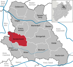
Location of Sendenhorst within Warendorf district
(2022-12-31)[2]
48324
02535 Albersloh
Sendenhorst is a town in the district of Warendorf, in North Rhine-Westphalia, Germany. It is situated approximately 20 km (12 mi) north of Hamm and 20 km (12 mi) south-east of Münster.
Geography
Sendenhorst consists of Sendenhorst and Albersloh. Before the municipal reform of 1975, Sendenhorst was located in the former Beckum District and Albersloh in the former district of Münster (Landkreis). The river Werse flows through Albersloh.
References
- ^ Wahlergebnisse in NRW Kommunalwahlen 2020, Land Nordrhein-Westfalen, accessed 30 June 2021.
- ^ "Bevölkerung der Gemeinden Nordrhein-Westfalens am 31. Dezember 2022 – Fortschreibung des Bevölkerungsstandes auf Basis des Zensus vom 9. Mai 2011" (in German). Landesbetrieb Information und Technik NRW. Retrieved 20 June 2023.
- v
- t
- e
Towns and municipalities in Warendorf (district)

Authority control databases | |
|---|---|
| International |
|
| National |
|
| This Warendorf district location article is a stub. You can help Wikipedia by expanding it. |
- v
- t
- e


