Shadaw
Place in Kayah State, Myanmar
Shadaw ရှားတောမြို့ | |
|---|---|
| 19°36′0″N 97°31′0″E / 19.60000°N 97.51667°E / 19.60000; 97.51667 | |
| Country |  Myanmar Myanmar |
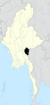
| Division |  Kayah State Kayah State |
| District | Loikaw District |
| Township | Shadaw Township |
| Population (2005) | |
| • Religions | Buddhism |
| Time zone | UTC+6.30 (MST) |
Shadaw (Burmese: ရှားတောမြို့) is a town in the Kayah State of eastern part of Burma.
External links
- Satellite map at Maplandia.com
- v
- t
- e
Kayah State
Capital: Loikaw
- Bawlakhe Township
- Hpasawng Township

- Demoso Township
- Hpruso Township
  | This Kayah State location article is a stub. You can help Wikipedia by expanding it. |
- v
- t
- e


