Sharpness railway station
Former railway station in England
Sharpness | |
|---|---|
| General information | |
| Location | Sharpness, Stroud England |
| Grid reference | SO676028 |
| Platforms | 2 (1 from 1931) |
| Other information | |
| Status | Disused |
| History | |
| Original company | Midland Railway |
| Pre-grouping | Severn and Wye and Severn Bridge Railway (GWR & MR joint line) |
| Post-grouping | S&W&SBR |
| Key dates | |
| 1 August 1876 (1876-08-01) | First station opened |
| 16 October 1879 | Station resited on different line |
| 2 November 1964 (1964-11-02) | Second station closed |
Sharpness railway station served the village and docks of Sharpness in Gloucestershire, England from 1875 to 1964.
History
Railways and Canals of the Forest of Dean | |||||||||||||||||||||||||||||||||||||||||||||||||||||||||||||||||||||||||||||||||||||||||||||||||||||||||||||||||||||||||||||||||||||||||||||||||||||||||||||||||||||||||||||||||||||||||||||||||||||||||||||||||||||||||||||||||||||||||||||||||||||||||||||||||||||||||||||||||||||||||
|---|---|---|---|---|---|---|---|---|---|---|---|---|---|---|---|---|---|---|---|---|---|---|---|---|---|---|---|---|---|---|---|---|---|---|---|---|---|---|---|---|---|---|---|---|---|---|---|---|---|---|---|---|---|---|---|---|---|---|---|---|---|---|---|---|---|---|---|---|---|---|---|---|---|---|---|---|---|---|---|---|---|---|---|---|---|---|---|---|---|---|---|---|---|---|---|---|---|---|---|---|---|---|---|---|---|---|---|---|---|---|---|---|---|---|---|---|---|---|---|---|---|---|---|---|---|---|---|---|---|---|---|---|---|---|---|---|---|---|---|---|---|---|---|---|---|---|---|---|---|---|---|---|---|---|---|---|---|---|---|---|---|---|---|---|---|---|---|---|---|---|---|---|---|---|---|---|---|---|---|---|---|---|---|---|---|---|---|---|---|---|---|---|---|---|---|---|---|---|---|---|---|---|---|---|---|---|---|---|---|---|---|---|---|---|---|---|---|---|---|---|---|---|---|---|---|---|---|---|---|---|---|---|---|---|---|---|---|---|---|---|---|---|---|---|---|---|---|---|---|---|---|---|---|---|---|---|---|---|---|---|---|---|---|---|---|---|---|---|---|---|---|---|---|---|---|---|---|---|---|---|---|
| |||||||||||||||||||||||||||||||||||||||||||||||||||||||||||||||||||||||||||||||||||||||||||||||||||||||||||||||||||||||||||||||||||||||||||||||||||||||||||||||||||||||||||||||||||||||||||||||||||||||||||||||||||||||||||||||||||||||||||||||||||||||||||||||||||||||||||||||||||||||||
| |||||||||||||||||||||||||||||||||||||||||||||||||||||||||||||||||||||||||||||||||||||||||||||||||||||||||||||||||||||||||||||||||||||||||||||||||||||||||||||||||||||||||||||||||||||||||||||||||||||||||||||||||||||||||||||||||||||||||||||||||||||||||||||||||||||||||||||||||||||||||


Severn Bridge Railway | ||||||||||||||||||||||||||||||||||||||||||||||||||||||||||||||||||||||||||||||||||||||||||||||||||||||||||||||||||||||||||||||||||||||||||||||||||||||||||||||||||||||||||||||||||||||
|---|---|---|---|---|---|---|---|---|---|---|---|---|---|---|---|---|---|---|---|---|---|---|---|---|---|---|---|---|---|---|---|---|---|---|---|---|---|---|---|---|---|---|---|---|---|---|---|---|---|---|---|---|---|---|---|---|---|---|---|---|---|---|---|---|---|---|---|---|---|---|---|---|---|---|---|---|---|---|---|---|---|---|---|---|---|---|---|---|---|---|---|---|---|---|---|---|---|---|---|---|---|---|---|---|---|---|---|---|---|---|---|---|---|---|---|---|---|---|---|---|---|---|---|---|---|---|---|---|---|---|---|---|---|---|---|---|---|---|---|---|---|---|---|---|---|---|---|---|---|---|---|---|---|---|---|---|---|---|---|---|---|---|---|---|---|---|---|---|---|---|---|---|---|---|---|---|---|---|---|---|---|---|
Legend | ||||||||||||||||||||||||||||||||||||||||||||||||||||||||||||||||||||||||||||||||||||||||||||||||||||||||||||||||||||||||||||||||||||||||||||||||||||||||||||||||||||||||||||||||||||||
| ||||||||||||||||||||||||||||||||||||||||||||||||||||||||||||||||||||||||||||||||||||||||||||||||||||||||||||||||||||||||||||||||||||||||||||||||||||||||||||||||||||||||||||||||||||||


Sharpness branch line | ||||||||||||||||||||||||||||||||||||||||||||||||||||||||||||||||||||||||||||||||||||||||||||||||||||||||||||||||||||||||||||||||||||||||||||
|---|---|---|---|---|---|---|---|---|---|---|---|---|---|---|---|---|---|---|---|---|---|---|---|---|---|---|---|---|---|---|---|---|---|---|---|---|---|---|---|---|---|---|---|---|---|---|---|---|---|---|---|---|---|---|---|---|---|---|---|---|---|---|---|---|---|---|---|---|---|---|---|---|---|---|---|---|---|---|---|---|---|---|---|---|---|---|---|---|---|---|---|---|---|---|---|---|---|---|---|---|---|---|---|---|---|---|---|---|---|---|---|---|---|---|---|---|---|---|---|---|---|---|---|---|---|---|---|---|---|---|---|---|---|---|---|---|---|---|---|---|
For canal icons used below, please refer to waterways legend instead. | ||||||||||||||||||||||||||||||||||||||||||||||||||||||||||||||||||||||||||||||||||||||||||||||||||||||||||||||||||||||||||||||||||||||||||||
Legend | ||||||||||||||||||||||||||||||||||||||||||||||||||||||||||||||||||||||||||||||||||||||||||||||||||||||||||||||||||||||||||||||||||||||||||||
| ||||||||||||||||||||||||||||||||||||||||||||||||||||||||||||||||||||||||||||||||||||||||||||||||||||||||||||||||||||||||||||||||||||||||||||


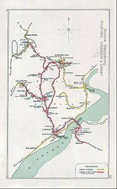
The station was on the Sharpness Branch Line, part of the Midland Railway, which connected the Bristol and Gloucester Railway main line at Berkeley Road station with the docks at Sharpness. The Sharpness New Docks & Gloucester & Birmingham Navigation Company started operation at Sharpness in 1874.[1] The branch line was opened to freight traffic in August 1875 with passenger services starting a year later.[2]
Sharpness station was originally a terminus for the passenger services and was no more than a temporary platform next to the docks. But in 1879, the Sharpness branch became a through-route with the opening of the Severn Railway Bridge, connecting Sharpness with the Forest of Dean side of the Severn Estuary and enabling through services between Berkeley Road and Lydney Town railway station, some of which ran on to Lydbrook.[3] The new station, built on a curve, had a brick building on the "up" platform (towards Berkeley) and a small shelter on the down platform. Children from Sharpness attending school in Lydney were among the passengers. After 1931, the line was singled.
Through-services to Lydney on the line ceased abruptly in October 1960 when the Severn Railway Bridge was damaged beyond economic repair in a shipping accident, and Sharpness resumed its earlier status as a branch line terminus. Passenger services ceased on the branch in November 1964 and goods facilities were withdrawn in January 1966. The station buildings were demolished. The line to the docks is still open for very occasional freight services.
The Vale of Berkeley Railway Group has campaigned to restore the station and railway.[4]
On 22 October 2019, Stroud District Council announced a draft plan to build a railway station in Sharpness, to support housebuilding plans.[5]
Services
| Preceding station | Disused railways | Following station | ||
|---|---|---|---|---|
| Berkeley | Sharpness Branch Line | Terminus | ||
| Severn Bridge Railway | Severn Bridge |
References
- ^ "Gloucester: Quay and docks Pages 251-258 A History of the County of Gloucester: Volume 4, the City of Gloucester". British History Online. Victoria County History, 1988. Retrieved 28 November 2022.
- ^ Mike Oakley (2003). Gloucestershire Railway Stations. Wimborne: Dovecote Press. p. 121. ISBN 1-904349-24-2.
- ^ "Lydney Pages 46-84 A History of the County of Gloucester: Volume 5, Bledisloe Hundred, St. Briavels Hundred, the Forest of Dean". British History Online. Victoria County History, 1996. Retrieved 28 November 2022.
- ^ "Vale of Berkeley Railway". Vale of Berkeley Railway. Retrieved 28 November 2022.
- ^ "Stroud plans garden villages and new railway station". BBC News. 22 October 2019.
51°43′22″N 2°28′11″W / 51.7228°N 2.4697°W / 51.7228; -2.4697
 | This article about a railway station in South West England is a stub. You can help Wikipedia by expanding it. |
- v
- t
- e
 | This article about a Gloucestershire building or structure is a stub. You can help Wikipedia by expanding it. |
- v
- t
- e


