Spicket River
River in Massachusetts, United States
42°51′27″N 71°12′48″W / 42.85750°N 71.21333°W / 42.85750; -71.21333 • location
• coordinates
• elevation
The Spicket River is a 17.7-mile-long (28.5 km)[1] river located in New Hampshire and Massachusetts in the United States. It is a left tributary of the Merrimack River, part of the Gulf of Maine watershed. It is sometimes spelled "Spickett".[2]
The Spicket River begins at the outlet of Island Pond in Derry, New Hampshire, and flows south into Salem, New Hampshire, passing through the Arlington Mill Reservoir. The river continues through Salem, encountering copious suburban development, and enters the city of Methuen, Massachusetts, where it drops nearly 100 feet (30 m) in elevation over a series of dams on its way to the Merrimack River in Lawrence.
-
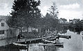 Boat house circa 1900 in Methuen, Massachusetts
 -
 Broadway Bridge, Methuen
 -
 Spicket River Dam in Methuen
 -
 Sands Bridge on Hampshire Rd, Methuen


See also
 New Hampshire portal

References
- v
- t
- e
- Amoskeag Falls
- Bear Brook State Park
- Belknap Mountains
- Blackwater Dam
- Egg Rock
- Franconia Notch State Park
- Franklin Falls Dam
- Gunstock Mountain
- Hannah Duston Memorial
- Hobo Railroad
- Lakes Region
- Lost River Reservation
- Middlesex Canal
- Minute Man National Historical Park
- Mount Major
- Mount Monadnock
- Mount Pemigewasset
- Mount Rowe
- Pawtucket Falls
- Pemigewasset Wilderness
- Sculptured Rocks Natural Area
- Wellington State Park
- White Mountains
| Authority control databases |
|
|---|
 | This Essex County, Massachusetts geography–related article is a stub. You can help Wikipedia by expanding it. |
- v
- t
- e
This article related to a river in Massachusetts is a stub. You can help Wikipedia by expanding it. |
- v
- t
- e
This article related to a river in New Hampshire is a stub. You can help Wikipedia by expanding it. |
- v
- t
- e


