St George East
District on the eastern edge of Bristol, England
Human settlement in England
- Bristol
- Bristol
- South West
St George East is a district (ward) on the eastern edge of Bristol, England. It includes the neighbourhoods of St. George, Burchells Green, Crew's Hole, and Two Mile Hill.
Crew's Hole
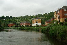

Crew's Hole is located in east Bristol near St George.
From the early 18th century, Crew's Hole was an industrial area that included oil refineries and a tar works site at the bottom of Troopers Hill.[1]
The tar works was established by Isambard Kingdom Brunel in 1843 to provide creosote to be used as a preservative for railway sleepers and by 1863 had passed into the ownership of Brunel's manager, William Butler. It continued to operate until 1981.[2]
Two Mile Hill
Two Mile Hill is an area on the eastern edge of St. George East, bordering Kingswood.[3]
Population
According to the 2001 Census, there are 11,348 people living in St George East, with over 95% of the population being white. It has only seven Jewish residents.[4]
See also
References
- ^ Holland, Raymond. "A History of Tar Distillation at Crew's Hole, Bristol". Society of Chemical Industry. Retrieved 12 January 2016.
- ^ "Hill History". Troopers Hill. Retrieved 12 January 2016.
- ^ "Two Mile Hill Gloucestershire". A Vision of Britain. Retrieved 12 January 2016.
- ^ "2011 Census Profile: St George East" (PDF). Bristol City Council. Retrieved 12 January 2016.
Wikimedia Commons has media related to St George East (ward).
- v
- t
- e
- Bristol West
- Bristol East
- Bristol South
- Bristol North West
- Ashley
- Avonmouth and Lawrence Weston
- Bedminster
- Bishopston and Ashley Down
- Bishopsworth
- Brislington East
- Brislington West
- Central
- Clifton
- Clifton Down
- Cotham
- Easton
- Eastville
- Filwood
- Frome Vale
- Hartcliffe and Withywood
- Henbury and Brentry
- Hengrove and Whitchurch Park
- Hillfields
- Horfield
- Hotwells and Harbourside
- Knowle
- Lawrence Hill
- Lockleaze
- Redland
- Southmead
- Southville
- St George Central
- St George Troopers Hill
- St George West
- Stockwood
- Stoke Bishop
- Westbury-on-Trym and Henleaze
- Windmill Hill
- City centre
- Arnos Vale
- Ashley Down
- Ashton Gate
- Ashton Vale
- Avonmouth
- Baptist Mills
- Barton Hill
- Bedminster
- Bedminster Down
- Bishopston
- Bishopsworth
- Blaise Hamlet
- Bower Ashton
- Brentry
- Brislington
- Broadmead
- Broom Hill near Brislington
- Broomhill near Fishponds
- Canon's Marsh
- Chester Park
- Chittening
- Clifton
- Cliftonwood
- Coombe Dingle
- Cotham
- Crew's Hole
- Crofts End
- Easton
- Eastville
- Filwood Park
- Fishponds
- Golden Hill
- Greenbank
- Hartcliffe
- Headley Park
- Henbury
- Hengrove
- Henleaze
- Hillfields
- Horfield
- Hotwells
- Kensington Park
- Kingsdown
- Knowle
- Knowle West
- Lawrence Hill
- Lawrence Weston
- Lockleaze
- Lodge Hill
- Mayfield Park
- Monks Park
- Montpelier
- Old City
- Redcliffe
- Redfield
- Redland
- Sea Mills
- Shirehampton
- Sneyd Park
- Southmead
- Southville
- Speedwell
- Spike Island
- St Andrew's
- St Anne's
- St. George
- St. Jude's
- St. Paul's
- St Philip's Marsh
- St. Werburgh's
- Stapleton
- Stockwood
- Stoke Bishop
- Totterdown
- Tyndall's Park
- Upper Knowle
- Westbury-on-Trym
- Westbury Park
- Whitehall
- Windmill Hill
- Withywood
The following suburbs are in the same urban area, but lie in South Gloucestershire or North Somerset:
51°27′35″N 2°31′42″W / 51.45972°N 2.52833°W / 51.45972; -2.52833
 | This Bristol location article is a stub. You can help Wikipedia by expanding it. |
- v
- t
- e


