Swartbroek
Village in Limburg, Netherlands
Swartbroek Swartbrook | |
|---|---|
Village | |
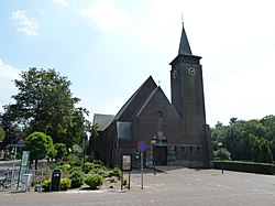 St Cornelius Church | |
51°14′N 5°46′E / 51.233°N 5.767°E / 51.233; 5.767 | |
| Country | Netherlands |
| Province | Limburg |
| Municipality | Weert |
| Area | |
| • Total | 6.98 km2 (2.69 sq mi) |
| Elevation | 32 m (105 ft) |
| Population (2021)[1] | |
| • Total | 870 |
| • Density | 120/km2 (320/sq mi) |
| Time zone | UTC+1 (CET) |
| • Summer (DST) | UTC+2 (CEST) |
| Postal code | 6005[1] |
| Dialing code | 0495 |
| Major roads | A2 N280 |
Swartbroek (Dutch pronunciation: [ˈsʋɑrdbruk]; Limburgish: Zwertbrook [ˈzwe̞ʀdbʀoːk]) is a village in the Netherlands, in the municipality of Weert in the province of Limburg.
The village was first mentioned in the 16th century as Swartbroeck, and means "black swampy land".[3]
Swartbroek was home to 276 people in 1840. In 1925, the St Cornelius Church was built. The grist mill De Hoop was built in 1905 using material from a 1788 wind mill. Between 2011 and 2015, it was restored and still in active service.[4]
Gallery
-
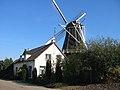 Windmill De Hoop
 -
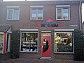 Tea pot museum


References
- ^ a b c "Kerncijfers wijken en buurten 2021". Central Bureau of Statistics. Retrieved 26 April 2022.
- ^ "Postcodetool for 6005AA". Actueel Hoogtebestand Nederland (in Dutch). Het Waterschapshuis. Retrieved 26 April 2022.
- ^ "Swartbroek". Etymologiebank (in Dutch). Retrieved 26 April 2022.
- ^ "Swartbroek". Plaatsengids (in Dutch). Retrieved 26 April 2022.
Wikimedia Commons has media related to Swartbroek.
- v
- t
- e


