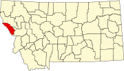
Tarkio, Montana
Unincorporated community in Montana, United States
47°1′17″N 114°42′20″W / 47.02139°N 114.70556°W / 47.02139; -114.70556Tarkio is an unincorporated community in Montana, United States, located in Mineral County. Tarkio falls in Mountain Time Zone (MST/MDT) and observes daylight saving time.
Tarkio's elevation is 2,936 feet (895 m) above sea level, and is approximately 40 miles (64 km) outside of Missoula. It lies along Interstate 90 with access via exit 61. The Clark Fork River flows to the west.
References
- ^ a b U.S. Geological Survey Geographic Names Information System: Tarkio, Montana
External links
- Tarkio page from roadsidethoughts.com
- v
- t
- e
Municipalities and communities of Mineral County, Montana, United States
County seat: Superior
- Alberton
- Superior

communities
- East Portal
- Tarkio
- Montana portal
- United States portal
 | This Mineral County, Montana state location article is a stub. You can help Wikipedia by expanding it. |
- v
- t
- e


