Toome Lower
Place in Northern Ireland, United Kingdom
Toome Lower Tuaim Íochtarach[1] (Irish) | |
|---|---|
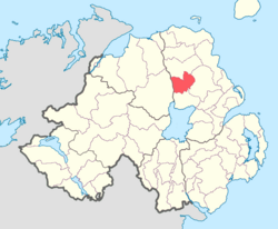 Location of Toome Lower, County Antrim, Northern Ireland. | |
| Sovereign state | United Kingdom |
| Country | Northern Ireland |
| County | Antrim |
Toome Lower is a barony in County Antrim, Northern Ireland.[2] It is bordered by four other baronies: Toome Upper to the south; Antrim Lower to the east; Kilconway to the north; and Loughinsholin to the west.[2] Toome Lower also formed part of the medieval territories known as the Route and Clandeboye.
History
List of settlements
Below is a list of settlements in Toome Lower:[1]
Towns
- Ahoghill (also part of baronies of Antrim Lower and Toome Upper)
- Antrim (also part of barony of Toome Upper)
- Cullybackey
- Portglenone
Population centres
- Gracehill
- Killygarn
- Lisrodden
List of civil parishes
Below is a list of civil parishes in Toome Lower:[3][4]
- Ahoghill
- Craigs
- Kirkinriola
- Portglenone
References
- v
- t
- e
Places in County Antrim

- Aghagallon
- Aghalee
- Ahoghill
- Aldergrove
- Armoy
- Aughafatten
- Ballinderry Upper
- Ballinderry Lower
- Ballintoy
- Ballybogy
- Ballycarry
- Ballyeaston
- Ballygally
- Ballylinny
- Ballynure
- Ballyrobert
- Ballystrudder
- Ballyvoy
- Balnamore
- Bendooragh
- Broughshane
- Buckna
- Bushmills
- Capecastle
- Cargan
- Carnalbanagh
- Carncastle
- Carnlough
- Clogh
- Cloghmills
- Cogry-Kilbride
- Craigarogan
- Crumlin
- Cullybackey
- Cushendall
- Cushendun
- Dervock
- Derrymore
- Doagh
- Donegore
- Drains Bay
- Dunadry
- Dundrod
- Dunloy
- Gawley's Gate
- Glenarm
- Glenavy
- Glenoe
- Glynn
- Gracehill
- Grange Corner
- Greenisland
- Groggan
- Kells and Connor
- Kellswater
- Keshbridge
- Killead
- Knocknacarry
- Longkesh
- Loughguile
- Lurganure
- Maghaberry
- Magheramorne
- Martinstown
- Mill Bay
- Millbank
- Milltown
- Moneyglass
- Monkstown
- Moss-side
- Mounthill
- Mullaghboy
- Newtown Crommelin
- Parkgate
- Portballintrae
- Portbraddon
- Portglenone
- Rasharkin
- Roughfort
- Stoneyford
- Straid
- Stranocum
- Templepatrick
- Toome
- Tullynacross
- Waterfoot
- Whitehead
- Antrim Lower
- Antrim Upper
- Belfast Lower
- Belfast Upper
- Carrickfergus
- Cary
- Dunluce Lower
- Dunluce Upper
- Glenarm Lower
- Glenarm Upper
- Kilconway
- Massereene Lower
- Massereene Upper
- Toome Lower
- Toome Upper
- WikiProject Northern Ireland
- WikiProject Ireland
- Northern Ireland Portal
- United Kingdom Portal
- Ireland Portal
 | This article related to the geography of County Antrim, Northern Ireland is a stub. You can help Wikipedia by expanding it. |
- v
- t
- e


