Tegeia
| Tegea Τεγέα | |
|---|---|
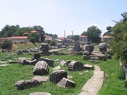 Kuil Athena Alea di Tegea | |
| Letak | |
  | |
| Koordinat | 37°27.32′N 22°25.23′E / 37.45533°N 22.42050°E / 37.45533; 22.42050Koordinat: 37°27.32′N 22°25.23′E / 37.45533°N 22.42050°E / 37.45533; 22.42050 |
| Zona waktu: | EET/EEST (UTC+2/3) |
| Ketinggian (puncak): | 650 m (2.133 ft) |
| Pemerintah | |
| Negara: | Yunani |
| Periferal: | Peloponnesa |
| Kotamadya: | Tripoli |
| Statistik penduduk (pada 2001[1]) | |
| Kode | |
| Kode pos: | 220 12 |
| Kode telepon: | 2710 |
| Plat kendaraan: | TP |
 | |
Tegea (bahasa Yunani: Τεγέα) adalah sebuah pemukiman pada zaman Yunani Kuno, dan ia juga adalah bekas kota di Arkadia, Peloponnesa, Yunani. Sejak reformasi pemerintah lokal 2011, Tegea menjadi bagian kota Tripoli, yang merupakan unit kota.[2]
Subdivisi
- Alea
- Episkopi
- Garea
- Kamari
- Kandalos
- Kerasitsa, tempat kelahiran politikus Gregoris Lambrakis yang lahir pada 1912
- Lithovounia
- Magoula (Magoula, Giokareika)
- Manthyrea
- Mavriki
- Psili Vrysi (Psili Vrysi, Bouzaneika)
- Rizes
- Stadio (Stadio, Agios Sostis, Akra)
- Tzivas
- Vouno
- Strigkos (Strigkos, Demiri)
Sejarah populasi
| Year | Population |
|---|---|
| 1991 | 4,539 |
| 2001 | 3,858 |
Orang
Referensi
- ^ "(875 KB) 2001 Census" (PDF). National Statistical Service of Greece (ΕΣΥΕ) (dalam bahasa Greek). www.statistics.gr. Diakses tanggal 2007-10-30. Pemeliharaan CS1: Bahasa yang tidak diketahui (link)
- ^ Kallikratis law Diarsipkan 2017-04-27 di Wayback Machine. Greece Ministry of Interior (Yunani)
Pranala luar
- Perseus site: Tegea Photo gallery of archaeologuical sites and bibliography.
- (Roy George), Temple of Athena Alea at Tegea
- GTP - Ancient Tegea
- GTP - Municipality of Tegea
- GTP - Alea, the present name of Tegea
- Tegea - black-and-white photo essay of the site and related artifacts
- Tegean Ancient Army - a brief peer-reviewed essay discussing the army of the ancient Tegea
- l
- b
- s


