Arnsdorf
 Disambiguazione – Se stai cercando altri significati, vedi Arnsdorf (disambigua).
| Arnsdorf comune | |
|---|---|
 | |
 | |
| Localizzazione | |
| Stato |  Germania Germania |
| Land |  Sassonia Sassonia |
| Distretto | Dresda |
| Circondario | Bautzen |
| Territorio | |
| Coordinate | 51°06′00″N 13°58′59.88″E51°06′00″N, 13°58′59.88″E |
| Altitudine | 290 m s.l.m. |
| Superficie | 35,87 km² |
| Abitanti | 5 047[1] (31-12-2022) |
| Densità | 140,7 ab./km² |
| Altre informazioni | |
| Cod. postale | 01477 |
| Prefisso | 035200 |
| Fuso orario | UTC+1 |
| Codice Destatis | 14 6 25 010 |
| Targa | BZ |
| Cartografia | |
  Arnsdorf | |
 | |
| Sito istituzionale | |
| Modifica dati su Wikidata · Manuale | |
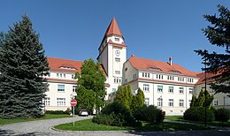
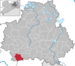
Arnsdorf è un comune di 5 047 abitanti[1] della Sassonia, in Germania.
Appartiene al circondario (Landkreis) di Bautzen (targa BZ).
Note
Altri progetti
Altri progetti
- Wikimedia Commons
 Wikimedia Commons contiene immagini o altri file su Arnsdorf
Collegamenti esterni
- (DE) Sito ufficiale, su gemeindearnsdorf.de.


V · D · M Comuni del circondario di Bautzen  | |
|---|---|
| Città | Bautzen · Bernsdorf · Bischofswerda · Elstra · Großröhrsdorf · Hoyerswerda · Kamenz · Königsbrück · Lauta · Pulsnitz · Radeberg · Schirgiswalde-Kirschau · Weißenberg · Wilthen · Wittichenau |
| Comuni | Arnsdorf · Burkau · Crostwitz · Cunewalde · Demitz-Thumitz · Doberschau-Gaußig · Elsterheide · Frankenthal · Göda · Großdubrau · Großharthau · Großnaundorf · Großpostwitz/O.L. · Haselbachtal · Hochkirch · Königswartha · Kubschütz · Laußnitz · Lichtenberg · Lohsa · Malschwitz · Nebelschütz · Neschwitz · Neukirch · Neukirch/Lausitz · Obergurig · Ohorn · Oßling · Ottendorf-Okrilla · Panschwitz-Kuckau · Puschwitz · Räckelwitz · Radibor · Ralbitz-Rosenthal · Rammenau · Schmölln-Putzkau · Schönteichen · Schwepnitz · Sohland a. d. Spree · Spreetal · Steina · Steinigtwolmsdorf · Wachau |
| Controllo di autorità | VIAF (EN) 142251465 · GND (DE) 4460877-9 |
|---|
 Portale Germania: accedi alle voci di Wikipedia che parlano della Germania


