アトリット
| アトリット עַתְלִית | |
|---|---|
 アトリットの住宅地 | |
| 座標 : 北緯31度41分14秒 東経34度56分18秒 / 北緯31.68722度 東経34.93833度 / 31.68722; 34.93833 | |
| 行政 | |
| 国 |  イスラエル イスラエル |
| 行政区 | ハイファ地区 |
| 地域評議会(英語版) | ホフ・ハカーメル(英語版) |
| 町 | アトリット |
| 人口 | |
| 人口 | (2022年現在) |
| 町域 | 10,639人 |
| その他 | |
| 等時帯 | イスラエル標準時 |
| 公式ウェブサイト : http://www.atlit.org.il/mainsite.asp | |
アトリット (ヘブライ語: עַתְלִית,英語: Atlit) は、イスラエルハイファ地区の海岸沿いにある町である。
町の名前は、町の北約2kmに位置する十字軍の要塞都市アトリット(シャトー・ペルラン)(英語版)にちなんで名づけられた。
現在のアトリットの町は、1903年にユダヤ人支援者として知られるエドモン・バンジャマン・ド・ロチルド男爵によってユダヤ人入植地として整備されたものである。イギリス委任統治領時代、アトリットの近くにパレスチナ地域(エレツ・イスラエル)への不法移民(アリーヤー)を収容するアトリット収容所(英語版)が建設され、現在は博物館として整備されている[1]。
アトリットの沖合の海底には、アトリットヤム(英語版)として知られる、新石器時代の集落の遺跡がある。
歴史
新石器時代
アトリットヤム(英語版)は、アトリット沖合で発見された新石器時代の集落の遺跡で、放射性炭素年代測定法により、約8,900年~8,300年前のものと推定されている[2]。
青銅器時代
現在のアトリットにあたる地域には、青銅器時代頃から人類が居住していた痕跡が確認されている。
十字軍時代
十字軍は、第5回十字軍中の1218年に、アトリットの名でも知られる要塞都市シャトー・ペルラン(英語版)を建設した。この要塞は聖地エルサレム周辺に建設された要塞の中でも最大規模のものの一つで、テンプル騎士団の拠点として使用された。
1291年5月にアッコが陥落した3か月後、1291年8月にアトリットも陥落し、十字軍は聖地周辺の拠点を失う事となった[3]。
要塞の遺構は現在も残っており、要塞のすぐ北には大規模な十字軍墓地も残されている[4][5]。
町の建設
1903年、アトリットの遺跡の約2km南方にユダヤ人入植者が村落を建設した[6]。この村は、ロスチャイルド家のエドモン・バンジャマン・ド・ロチルド男爵がアラブ人の漁師から買い取った土地に建設され[7]、約100世帯が入植したが、湿地帯であったため多くの住民がマラリアで命を落とした[8]。
イギリス委任統治領時代
1920年代、アトリットに製塩工場が建設され、アトリットの人口増加に寄与した[9]。この工場は現在もイスラエル製塩会社(ヘブライ語版)の工場として稼働している。
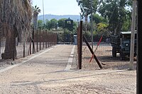
1930年代後半、イギリス委任統治領パレスチナ当局によって、パレスチナ地域(エレツ・イスラエル)へのユダヤ人不法移民(アリーヤー)を主に収容する目的でアトリット収容所(英語版)が設立された[10]。この時期のユダヤ人移民の多くが、ナチス・ドイツの占領下にあったヨーロッパ各地からの移民であった。第二次世界大戦直後には、多くのホロコースト生存者が移民としてパレスチナ地域に移住を試み、この収容所に一時収容されていた。1945年10月にユダヤ人武装組織ハガナーの精鋭部隊パルマッハの隊員らがアトリット収容所を襲撃し、208人の収容者を解放した。この襲撃は当時まだ若い戦闘指揮官であったイツハク・ラビンが計画したものであった。この襲撃ののち、イギリス当局は収容者をキプロス強制収容所(英語版)に移送した。
イスラエル建国後
1948年から49年にかけての第一次中東戦争の期間中、アトリットの収容所はイスラエル軍によって地元アラブ系住民やアラブ系武装勢力の捕虜収容所として使用された。また、第三次中東戦争で捕虜となったアラブ系の軍人の中にも、この収容所に移送された者があった。
1960年代頃より、アトリット周辺の海岸では水没した集落や難破船の遺構などが発見されるようになった。1984年、海洋考古学者エフド・ガリリが難破船の調査の途中、アトリット沖合の集落の遺構を発見したものが、現在アトリットヤム(英語版)として知られる遺跡である[11]。1987年のハイファ大学による調査では、埋葬された人骨が良好な状態で発見された。
2021年8月には、アトリットの海岸で約1700年前(西暦4世紀)頃の硬貨が大量に発見された。発見された約6kgの硬貨は、長年にわたる酸化の影響で互いに凝結し、大きな塊となっていた[12][13][14]。
アトリット要塞(シャトー・ペルラン)(英語版)の遺跡は現在、イスラエル海軍の拠点の一つであるアトリット海軍基地(英語版)の敷地内となり、一般人の立ち入りは制限されている[15]。アトリット海軍基地の詳細は機密とされているが、イスラエル海軍の精鋭特殊部隊シャイェテット・13の拠点であることが知られている。
行政区分としては、1950年から2004年までアトリットは単独の地方評議会(英語版)として存立していたが、2004年にホフ・ハカーメル地域評議会(英語版)の一部として再編された。
画像
-
 アトリットヤム(英語版)
 -
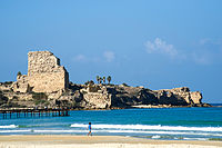 シャトー・ペルラン(英語版)
 -
 十字軍墓地
十字軍墓地 -
 アトリット収容所(英語版)
 -
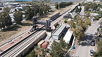 アトリット駅(英語版)
 -
 製塩工場
製塩工場 -
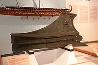 アトリットで発掘された衝角(イスラエル国立海洋博物館(英語版))
 -
 1903年のアトリットを撮影した写真。


姉妹都市


参考文献
- Abu-Husayn, Abdul-Rahim (1985). Provincial Leaderships in Syria, 1575–1650. Beirut: American University of Beirut. ISBN 9780815660729. OCLC 242675094. https://books.google.com/books?id=D1ttAAAAMAAJ
- Barron, J. B., ed (1923). Palestine: Report and General Abstracts of the Census of 1922. Government of Palestine. https://archive.org/details/PalestineCensus1922
- Conder, C.R.; Kitchener, H.H. (1881). The Survey of Western Palestine: Memoirs of the Topography, Orography, Hydrography, and Archaeology. 1. London: Committee of the Palestine Exploration Fund. https://archive.org/details/surveyofwesternp01conduoft p. 281
- Department of Statistics (1945). Village Statistics, April, 1945. Government of Palestine. http://web.nli.org.il/sites/nli/Hebrew/library/Pages/BookReader.aspx?pid=856390
- Hartmann, M. (1883). “Die Ortschaftenliste des Liwa Jerusalem in dem türkischen Staatskalender für Syrien auf das Jahr 1288 der Flucht (1871)”. Zeitschrift des Deutschen Palästina-Vereins 6: 102–149. https://archive.org/details/bub_gb_BZobAQAAIAAJ.
- Hadawi, S. (1970). Village Statistics of 1945: A Classification of Land and Area ownership in Palestine. Palestine Liberation Organization Research Center. オリジナルの2018-12-08時点におけるアーカイブ。. https://web.archive.org/web/20181208215837/http://www.palestineremembered.com/Articles/General-2/Story3150.html 2014年11月8日閲覧。
- Irby, C.L.; Mangles, J. (1823). Travels in Egypt and Nubia, Syria, and Asia Minor; during the years 1817 & 1818. London: Printed for Private Distribution by T. White & Co.. https://archive.org/details/travelsinegypta01barkgoog Irby and Mangles, 1823, p. 191
- Khalidi, W. (1992). All That Remains: The Palestinian Villages Occupied and Depopulated by Israel in 1948. Washington D.C.: Institute for Palestine Studies. ISBN 0-88728-224-5. https://books.google.com/books?id=_By7AAAAIAAJ
- Karmon, Y. (1960). “An Analysis of Jacotin's Map of Palestine”. Israel Exploration Journal 10 (3,4): 155–173; 244–253. オリジナルの2019-12-22時点におけるアーカイブ。. https://web.archive.org/web/20191222063351/http://jchp.ucla.edu/Bibliography/Karmon,_Y_1960_Jacotin_Map_(IEJ_10).pdf 2017年9月5日閲覧。.
- Mills, E., ed (1932). Census of Palestine 1931. Population of Villages, Towns and Administrative Areas. Jerusalem: Government of Palestine. https://archive.org/details/CensusOfPalestine1931.PopulationOfVillagesTownsAndAdministrativeAreas
- Morris, B. (2004). The Birth of the Palestinian Refugee Problem Revisited. Cambridge University Press. ISBN 978-0-521-00967-6. https://books.google.com/books?id=uM_kFX6edX8C
- Palmer, E. H. (1881). The Survey of Western Palestine: Arabic and English Name Lists Collected During the Survey by Lieutenants Conder and Kitchener, R. E. Transliterated and Explained by E.H. Palmer. Committee of the Palestine Exploration Fund. https://archive.org/details/surveyofwesternp00conduoft
- Robinson, David M. (2020). In the Shadow of the Mongol Empire Ming China and Eurasia. Cambridge: Cambridge University Press. ISBN 978-1-108-48244-8. https://books.google.com/books?id=itKyDwAAQBAJ&pg=PA32
- Schumacher, G. (1888). “Population list of the Liwa of Akka”. Quarterly Statement - Palestine Exploration Fund 20: 169–191. https://archive.org/details/quarterlystateme19pale.
- Socin, A. (1879). “Alphabetisches Verzeichniss von Ortschaften des Paschalik Jerusalem”. Zeitschrift des Deutschen Palästina-Vereins 2: 135–163. https://archive.org/details/zeitschriftdesde01deut.
脚注
- ^ “Pre-State Israel: Atlit Immigration Camp”. Jewish Virtual Library (2017年). 2017年5月17日閲覧。
- ^ Marine archaeologyArchived June 6, 2011, at the Wayback Machine.
- ^ Holt, Peter Malcolm (1986). The Age of the Crusades: The Near East from the Eleventh Century to 151. Addison Wesley Longman Limited. p. 104. ISBN 9781317871521. https://books.google.com/books?id=TqasAgAAQBAJ&pg=PA104
- ^ Gleize, Yves; Vivas, Mathieu; Dorso, Simon; Castex, Dominique (3 April 2020). “Le cimetière d’Atlit, un espace des morts au pied de Château-Pèlerin (royaume latin de Jérusalem - xiiie siècle)”. Les vivants et les morts dans les sociétés médiévales : XLVIIIe Congrès de la SHMESP (Jérusalem, 2017). Éditions de la Sorbonne. pp. 187–204. ISBN 979-10-351-0577-8. https://books.openedition.org/psorbonne/53803
- ^ Gleize, Yves; Dorso, Simon (2019). “'Atlit, Crusader Cemetery”. Hadashot Arkheologiyot 131. https://www.hadashot-esi.org.il/report_detail_eng.aspx?id=25609.
- ^ Sandra M. Sufian (2008) Healing the Land and the Nation: Malaria and the Zionist Project in Palestine, 1920-1947, University of Chicago Press, p103
- ^ Atlit Jewish Virtual Library
- ^ The Claim of Disspossesion, Arieh Avneri
- ^ Barron, 1923, Table XI, Sub-district of Haifa, p. 33
- ^ “The End of the Line”. 2013年1月3日時点のオリジナルよりアーカイブ。2016年2月5日閲覧。
- ^ Marchant, Jo (25 November 2009). “Deep Secrets: Atlit-Yam, Israel”. New Scientist (Reed Business Information Ltd.) (2736): 40, 41. ISSN 0262-4079. https://www.newscientist.com/article/mg20427361.400-atlityam-israel.html 2009年11月28日閲覧。.
- ^ “Ancient 1,700-year-old coins found on Israeli beach” (英語). The Jerusalem Post | JPost.com. 2021年8月27日閲覧。
- ^ Gershon, Livia. “Israeli Tour Guide on Camping Trip Discovers 1,700-Year-Old Coins” (英語). Smithsonian Magazine. 2021年8月27日閲覧。
- ^ “1,700-Year-Old Coins Were Just Discovered Clumped Together on a Beach” (英語). Observer (2021年8月19日). 2021年8月27日閲覧。
- ^ The Most Beautiful Place in Israel That You Can’t See, Haaretz
外部リンク
ウィキメディア・コモンズには、アトリットに関連するカテゴリがあります。
- 公式サイト


