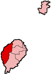
Lembá
District in Sao Tomé en Principe  | |||
|---|---|---|---|
 | |||
| Eiland | Sao Tomé | ||
| Coördinaten | 0°16'52"NB, 6°29'58"OL | ||
| Algemeen | |||
| Oppervlakte | 229,5[1] km² | ||
| Inwoners (2012) | 15.370[2] | ||
| Hoofdstad | Neves | ||
| |||

Lembá is een district in het westen van het tot Sao Tomé en Principe behorende eiland Sao Tomé.
Geografie
Lembá heeft een oppervlakte van 229,5 km² en 15.370 inwoners (2012). De hoofdstad van het district is Neves, Santa Catarina is het tweede grootste dorp; deze twee plaatsen vormen ook de twee subdistricten.[2] Het district wordt in het oosten begrensd door (van noord naar zuid) Lobata, Mé-Zóchi en Caué.
Lembá levert zes zetels in de Assembleia Nacional.[3]
Bevolkingsontwikkeling
| Jaar | Inwoners | Aandeel totale bevolking |
|---|---|---|
| 1940 | 6.885 | 11,4% |
| 1950 | 6.196 | 10,3% |
| 1960 | 6.196 | 9,7% |
| 1970 | 6.206 | 8,4% |
| 1981 | 7.905 | 8,2% |
| 1991 | 9.016 | 7,7% |
| 2001 | 10.696 | 7,8% |
| 2006 | 11.759[1] | 7,7% |
| 2012 | 15.370[2] | 8,2% |
Sport
Een voetbalclub die haar thuisbasis heeft in Lembá is FC Neves.
Bronnen, noten en/of referenties
|

Deelgebieden (hoofdsteden) van Sao Tomé en Principe
Provincies: Sao Tomé (Sao Tomé) · Principe (Santo António)
Districten: Água Grande (Sao Tomé) · Cantagalo (Santana) · Caué (São João dos Angolares) · Lembá (Neves) · Lobata (Guadalupe) · Mé-Zóchi (Trindade) · Pagué (Santo António)
Eilanden: Ilhéu Bom Bom · Ilhéu das Cabras · Ilhéu Caroço · Principe · Ilhéu das Rolas · Ilhéu de Santana · Sao Tomé · Tinhosa Grande · Tinhosa Pequena


