Lièpvre
Gemeente in Frankrijk  | |||
|---|---|---|---|
 | |||
  | |||
| Situering | |||
| Regio | Grand Est | ||
| Departement | Haut-Rhin (68) | ||
| Arrondissement | Colmar-Ribeauvillé | ||
| Kanton | Sainte-Marie-aux-Mines | ||
| Coördinaten | 48° 16′ NB, 7° 17′ OL | ||
| Algemeen | |||
| Oppervlakte | 12,55 km² | ||
| Inwoners (1 januari 2021) | 1.653[1] (132 inw./km²) | ||
| Hoogte | 234 - 930 m | ||
| Overig | |||
| Postcode | 68660 | ||
| INSEE-code | 68185 | ||
| Detailkaart | |||
 | |||
| Foto's | |||
 | |||
| |||

Lièpvre is een gemeente in het Franse departement Haut-Rhin (regio Grand Est) en telt 1733 inwoners (2005). De plaats maakt deel uit van het arrondissement Colmar-Ribeauvillé.
Geografie
De oppervlakte van Lièpvre bedraagt 12,6 km², de bevolkingsdichtheid is 137,5 inwoners per km².
De onderstaande kaart toont de ligging van Lièpvre met de belangrijkste infrastructuur en aangrenzende gemeenten.
 |
Demografie
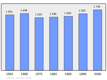
Onderstaande figuur toont het verloop van het inwonertal (bron: INSEE-tellingen).
Externe links
- (fr) Statistische informatie op de website van INSEE
Gemeenten in het kanton Sainte-Marie-aux-Mines
Ammerschwihr · Aubure · Beblenheim · Bennwihr · Bergheim · Le Bonhomme · Fréland · Guémar · Hunawihr · Illhaeusern · Katzenthal · Kaysersberg Vignoble · Labaroche · Lapoutroie · Lièpvre · Mittelwihr · Orbey · Ostheim · Ribeauvillé · Riquewihr · Rodern · Rombach-le-Franc · Rorschwihr · Saint-Hippolyte · Sainte-Croix-aux-Mines · Sainte-Marie-aux-Mines · Thannenkirch · Zellenberg
Mediabestanden
Zie de categorie Lièpvre van Wikimedia Commons voor mediabestanden over dit onderwerp.
- ↑ Populations légales 2021.


