Upper Arley
Civil parish in Engeland  | |||
|---|---|---|---|
  | |||
| Situering | |||
| Regio | West Midlands | ||
| Graafschap | Worcestershire | ||
| District | Wyre Forest | ||
| Coördinaten | 52° 25' NB, 2° 21' WL | ||
| Algemeen | |||
| Oppervlakte | 17,0804 km² | ||
| Inwoners (2011) | 741 (43 inw./km²) | ||
| Overig | |||
| Postcode(s) | DY12 | ||
| Grid code | SO765805 | ||
| Post town | BEWDLEY | ||
| ONS-code | E04010456 | ||
| Foto's | |||
 | |||
| De rivier de Severn | |||
| |||

Upper Arley is een civil parish in het bestuurlijke gebied Wyre Forest, in het Engelse graafschap Worcestershire met 741 inwoners.
-
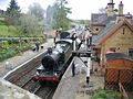 Station van Arley

Mediabestanden
Zie de categorie Upper Arley van Wikimedia Commons voor mediabestanden over dit onderwerp.
Civil parishes in het ceremoniële graafschap Worcestershire
Abberley · Abberton · Abbots Morton · Aldington · Alfrick · Alvechurch · Ashton under Hill · Astley and Dunley · Aston Somerville · Badsey · Barnt Green · Bayton · Beckford · Belbroughton · Bentley Pauncefoot · Beoley · Berrow · Besford · Bewdley · Bickmarsh · Birlingham · Birtsmorton · Bishampton · Bockleton · Bournheath · Bransford · Bredicot · Bredon · Bredon's Norton · Bretforton · Bricklehampton · Broadheath · Broadwas · Broadway · Broome · Broughton Hackett · Bushley · Castlemorton · Catshill and North Marlbrook · Chaddesley Corbett · Charlton · Childswickham · Church Lench · Churchill and Blakedown · Churchill · Cleeve Prior · Clent · Clifton upon Teme · Cofton Hackett · Conderton · Cookhill · Cotheridge · Croome D'Abitot · Cropthorne · Crowle · Defford · Doddenham · Dodderhill · Dodford with Grafton · Dormston · Doverdale · Drakes Broughton and Wadborough · Droitwich Spa · Earl's Croome · Eastham · Eckington · Eldersfield · Elmbridge · Elmley Castle · Elmley Lovett · Evesham · Feckenham · Finstall · Fladbury · Flyford Flavell · Frankley · Grafton Flyford · Great Comberton · Great Witley · Grimley · Guarlford · Hadzor · Hagley · Hallow · Hampton Lovett · Hanbury · Hanley Castle · Hanley · Hartlebury · Harvington · Hill and Moor · Hill Croome · Hillhampton · Himbleton · Hindlip · Hinton on the Green · Holdfast · Holt · Honeybourne · Huddington · Hunnington · Inkberrow · Kemerton · Kempsey · Kenswick · Kidderminster Foreign · Kington · Knighton on Teme · Knightwick · Kyre · Leigh · Lickey and Blackwell · Lickey End · Lindridge · Little Comberton · Little Malvern · Little Witley · Longdon · Lower Sapey · Lulsley · Madresfield · Malvern Wells · Malvern · Mamble · Martin Hussingtree · Martley · Naunton Beauchamp · Netherton · Newland · North and Middle Littleton · North Claines · North Piddle · Norton and Lenchwick · Norton Juxta Kempsey · Oddingley · Offenham · Ombersley · Overbury · Pebworth · Pendock · Pensax · Peopleton · Pershore · Pinvin · Pirton · Powick · Queenhill · Ribbesford · Ripple · Rochford · Rock · Romsley · Rous Lench · Rushock · Rushwick · Salwarpe · Sedgeberrow · Severn Stoke · Shelsley Beauchamp · Shelsley Kings · Shelsley Walsh · Shrawley · South Littleton · Spetchley · St. Peter the Great County · Stanford with Orleton · Stock and Bradley · Stockton on Teme · Stoke Bliss · Stoke · Stone · Stoulton · Stourport-on-Severn · Strensham · Suckley · Tenbury Wells · Throckmorton · Tibberton · Tutnall and Cobley · Upper Arley · Upton Snodsbury · Upton Warren · Upton-upon-Severn · Warndon · Welland · West Malvern · Westwood · White Ladies Aston · Whittington · Wichenford · Wick · Wickhamford · Wolverley and Cookley · Wyre Piddle · Wythall
Geplaatst op: 19-8-2010 | Dit artikel is een beginnetje over landen & volken. U wordt uitgenodigd om op bewerken te klikken om uw kennis aan dit artikel toe te voegen. |  |


