South Kesteven
| South Kesteven | |||
|---|---|---|---|
| | |||
| Land |  Storbritannia Storbritannia | ||
| Konst. land |  England England | ||
| Region | Øst-Midlands | ||
| Adm. grevskap | Lincolnshire | ||
| Seremonielt grevskap | Lincolnshire | ||
| Status | Distrikt | ||
| Grunnlagt | april 1974 | ||
| Adm. senter | Grantham | ||
| Areal | 942,59 km² | ||
| Befolkning | 133 788 (2011) | ||
| Bef.tetthet | 141,94 innb./km² | ||
| ONS-kode | 32UG | ||
 South Kesteven 52°48′N 0°30′V | |||
South Kesteven på Commons | |||
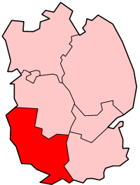
South Kesteven er et administrativt distrikt i Lincolnshire i England. Administrasjonssenteret er Grantham.
Distriktet ble opprettet 1. april 1974 ved sammenslåing av Grantham, Stamford, Bourne landdistrikt, South Kesteven landdistrikt og West Kesteven landdistrikt. Distriktet dekker et areal på 942,59 km² og hadde 133 788 innbyggere i 2011.[1]
South Kesteven grenser mot North Kesteven i nord, South Holland i øst, Rutland og Peterborough i sør og Leicestershire i vest.
Steder i distriktet
Referanser
- ^ «Census 2011: Usual resident population». Nomis. Office for National Statistics. Besøkt 5. juni 2018.
Eksterne lenker
- Offisielt nettsted

- (en) South Kesteven District – kategori av bilder, video eller lyd på Commons
Distrikter i Øst-Midlands | |||
|---|---|---|---|
 | Amber Valley · Ashfield · Bassetlaw · Blaby · Bolsover · Boston · Broxtowe · Charnwood · Chesterfield · Corby · Daventry · Derby · Derbyshire Dales · East Lindsey · East Northamptonshire · Erewash · Gedling · Harborough · High Peak · Hinckley and Bosworth · Kettering · Leicester · Lincoln · Mansfield · Melton · Newark and Sherwood · Northampton · North East Derbyshire · North Kesteven · North West Leicestershire · Nottingham · Oadby and Wigston · Rushcliffe · Rutland · South Derbyshire · South Holland · South Kesteven · South Northamptonshire · Wellingborough · West Lindsey |  | |
Administrative grevskap med flere distrikter: Derbyshire - Leicestershire - Lincolnshire - Northamptonshire - Nottinghamshire | |||


