Aalst, Buren
Hamlet in Gelderland, Netherlands
51°56′03″N 5°32′25″E / 51.93417°N 5.54028°E / 51.93417; 5.54028 (2021)[1]
4033[1]
Aalst is a hamlet in the Dutch province of Gelderland. It is a part of the municipality of Buren, and lies about 10 km southwest of Wageningen.
Between 1811 and 1998, Aalst belonged to the municipality of Lienden. In the middle of the 19th century, the population of Aalst was 150; there was a nice mansion called "Kolvenschoten" located here.[3]
It was first mentioned around 1400 as Aelst. The etymology is unclear.[4] The postal authorities have placed it under Lienden.[5] In 1840, it was home to 205 people.[6]
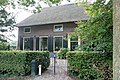
Gallery
-
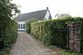 Farm in Aalst
 -
 Farm in Aalst


References
- ^ a b c "Kerncijfers wijken en buurten 2021". Central Bureau of Statistics. Retrieved 21 March 2022.
including Leutes
- ^ "Postcodetool for 4033AA". Actueel Hoogtebestand Nederland (in Dutch). Het Waterschapshuis. Retrieved 21 March 2022.
- ^ Abraham Jacob van der Aa, "Aardrijkskundig woordenboek der Nederlanden", vol. 1 (A), 1839, p. 15.
- ^ "Aalst - (geografische naam)". Etymologiebank (in Dutch). Retrieved 21 March 2022.
- ^ "Postcode 4033 in Lienden". Postcode bij adres (in Dutch). Retrieved 21 March 2022.
- ^ "Aalst (Lienden)". Plaatsengids (in Dutch). Retrieved 21 March 2022.
Wikimedia Commons has media related to Aalst (Buren).
Authority control databases | |
|---|---|
| International |
|
| National |
|
 | This Gelderland location article is a stub. You can help Wikipedia by expanding it. |
- v
- t
- e


