Beroroha (district)
District in Atsimo-Andrefana, Madagascar
Beroroha | |
|---|---|
District | |
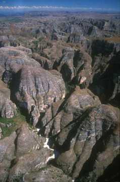 The Makay Massif | |
| Country |  Madagascar Madagascar |
| Region | Atsimo-Andrefana |
| Postal code | 611 |
Beroroha is a district of Atsimo-Andrefana in Madagascar.[1][2]
Roads
Beroroha lies on the Mangoky river. The road to Beroroha (National road 15) is unpaved and can only be taken by 4x4 pick-ups.
Municipalities
The district is further divided into nine municipalities:
- Behisatra (Behisatsy)
- Bemavo
- Beroroha
- Fanjakana
- Mandronarivo
- Marerano
- Sakena
- Tanamary
- Tanandava
Tourist sights
The Makay Massif is situated in the district of Beroroha.[3]
References
- ^ REPOBLIKAN’I MADAGASIKARA:Tanindrazana – Fahafahana – Fandrosoana (PDF). MINISTERE DE L’AGRICULTURE, DE L’ELEVAGE ET DE LA PECHE. October 2007. pp. 42–44. Archived from the original (PDF) on 2018-06-12. Retrieved 2018-06-09.
- ^ "Madagascar: Administrative Division". citypopulation. Retrieved 10 June 2018.
- ^ Beroroha
- v
- t
- e
Communes in the Atsimo-Andrefana Region of the Republic of MadagascarCapital: Toliara

- Ambatolahy
- Andranomafana
- Ankazoabo
- Ankeriky
- Ankilivalokely
- Ántevamena
- Berenty
- Fotivolo
- Ilemby
- Tandrano
- Ambalavato
- Ankilimary
- Benenitra
- Benonoky
- Ehara
- Ianapera
- Behisatra (Behisatsy)
- Bemavo
- Beroroha
- Fanjakana
- Mandronarivo
- Marerano
- Sakena
- Tanamary
- Tanandava
- Ambatry Mitsinjo
- Ankazomanga Ouest
- Ankazombalala
- Andranomangatsiaka
- Ankilivalo
- Antohabato
- Antsavoa
- Atsimo I
- Atsimo II
- Beantake
- Beavoha
- Belamoty
- Beora
- Besely
- Betioky
- Bezaha
- Efoetsy
- Fenoandala
- Lazarivo
- Manalobe
- Masiaboay
- Maroarivo Ankazomanga
- Montifeno
- Salobe
- Savazy II
- Sakamasay
- Soamanonga
- Soaserana
- Tameantsoa
- Tanambao Ambony
- Tongobory
- Vatolatsaka
- Vohimary
9 districts; 119 communes
 | This Madagascar location article is a stub. You can help Wikipedia by expanding it. |
- v
- t
- e


