Bonneterre Formation
Upper Cambrian geologic formation
| Bonneterre Formation | |
|---|---|
| Stratigraphic range: Guzhangian (Dresbachian) ~501–497 Ma PreꞒ Ꞓ O S D C P T J K Pg N ↓ | |
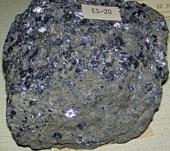 Galena in Bonneterre Dolomite (Upper Cambrian; Missouri) | |
| Type | Formation |
| Underlies | Davis Formation |
| Overlies | Lamotte Sandstone[1] |
| Lithology | |
| Primary | Dolomite |
| Other | Shale, limestone, sandstone |
| Location | |
| Coordinates |   Bonneterre Formation (the United States) Show map of the United States Bonneterre Formation (Missouri) Show map of Missouri |
The Bonneterre Formation is an Upper Cambrian geologic formation which outcrops in the St. Francois Mountains of the Missouri Ozarks. The Bonneterre is a major host rock for the lead ores of the Missouri Lead Belt.
Description
The formation is dominantly dolomite with areas or layers of pure limestone. A shaley or glauconitic zone occurs in the lower portion and the base contains sand and conglomerate or breccia where the formation overlaps the Lamotte and lies directly on the granite of the mountain core.[5]
Stratigraphy
Early geologists offered a variety of names for what is now known as the Bonneterre Formation.[1] In 1894, Missouri state geologist Arthur Winslow proposed St. Francois limestone as a name for thick limestone beds,[6] including everything between what are now known as the Lamotte Sandstone and the St. Peter Sandstone.[7] He described the lower part of that formation (now comprising the Bonneterre and the Elvins Group)[8] separately as the St. Joseph limestone.[9] Charles Rollin Keyes's Fredericktown limestone included everything between the Lamotte and the Potosi Dolomite when he first described it in 1896, but his later uses of the name were in a more restricted sense equivalent to the modern Bonneterre.[10]
In 1901, Frank Lewis Nason was the first to apply the name Bonneterre (originally spelled Bonne Terre) to these rocks,[1] identifying a type section near the city of Bonne Terre, Missouri.[11]
Contacts
The Bonneterre is conformably overlain by the Davis Formation. The Bonneterre Formation lies conformably on the Lamotte Sandstone and in places lies directly on the Proterozoic igneous core of the mountains.
Thickness
In the outcrop area the Bonneterre has an average thickness of 375 to 400 feet. It is present in the subsurface throughout Missouri and has a maximum recorded thickness of 1580 feet under Pemiscot County in the Missouri Bootheel.[5]
Fossils
The dolomites and limestones of the Bonneterre Formation contain fossils of late Cambrian invertebrates. Algal stromatolites, echinoderms, and microfossils such as Girvanella are associated with fringing reef paleoecosystems surrounding the Cambrian islands that are now the St. Francois Mountains.[12] A variety of trilobite fossils have been reported from the Bonneterre, including Coosella, Holcacephalus, Meteoraspis, Tricrepicephalus, and Welleraspis.[13][14] Several monoplacophorans have also been described from the Bonneterre; one, Hypseloconus bonneterrense is named for the formation.[14][15]
References
- ^ a b c Thompson 2001, p. 37.
- ^ Kurtz et al. 1975, p. 1.
- ^ Goebel 1968, p. 12.
- ^ a b Mossler 1987, p. 6.
- ^ a b Thompson 1995, pp. 18–19.
- ^ Winslow 1894, pp. 331, 346, 349–354.
- ^ Thompson 2001, p. 250.
- ^ Thompson 2001, p. 251.
- ^ Winslow 1894, pp. 331, 347.
- ^ Thompson 2001, p. 110.
- ^ Nason, F.L. (1901). "On the presence of a limestone conglomerate in the lead region of St. Francois County, Missouri". American Journal of Science. 4th. 12: 358–361.
- ^ Lyle, J. R. (1977). "Petrography and carbonate diagenesis of the Bonneterre Formation in the Viburnum Trend area, Southeast Missouri". Economic Geology. 72 (3): 420–434. doi:10.2113/gsecongeo.72.3.420.
- ^ Hu, Chung-Hung (1979). "692. Ontogenies of four Upper Cambrian trilobites from the Bonneterre Dolomite, Missouri". Transactions and Proceedings of the Paleontological Society of Japan. New Series. 1978 (111): 348–357. doi:10.14825/prpsj1951.1978.111_348.
- ^ a b Stinchcomb, B. L (1975). "Paleoecology of two new species of Late Cambrian Hypseloconus (Monoplacophora) from Missouri". Journal of Paleontology. 49 (2): 416–421. JSTOR 1303372.
- ^ Stinchcomb, Bruce; Angeli, Nicholas (2002). "New Cambrian and Lower Ordovician monoplacophorans form the Ozark Uplift, Missouri". Journal of Paleontology. 76 (6): 965–974. doi:10.1666/0022-3360(2002)076<0965:NCALOM>2.0.CO;2.
Bibliography
- Goebel, Edwin D. (1968). "Paleozoic Era". In Zeller, D. E. (ed.). The Stratigraphic Succession in Kansas. Kansas Geological Survey Bulletin 189. University of Kansas. p. 12.
- Kurtz, Vincent E.; Thacker, Joseph L.; Anderson, Kenneth H.; Gerdemann, Paul E. (1975). Traverse in Late Cambrian Strata from the St. Francois Mountains, Missouri to Delaware County, Oklahoma (PDF). Report of Investigations 55. Missouri Department of Natural Resources, Division of Research and Technical Information. LCCN 74-620007.
- Mossler, John H. (1987). Paleozoic Lithostratigraphic Nomenclature for Minnesota (PDF). Report of Investigations 36. University of Minnesota. ISSN 0076-9177.
- Stinchcomb, Bruce, and Nicholas Angeli. 2002. New Cambrian and Lower Ordovician monoplacophorans form the Ozark Uplift, Missouri. Journal of Paleontology 76(6). 965-974. .
- Thompson, Thomas L. (1995). The Stratigraphic Succession in Missouri (Revised 1995) (PDF). 2nd. Vol. 40 (Revised ed.). Missouri Department of Natural Resources, Division of Geology and Land Survey. LCCN 95-76805.
- Thompson, Thomas L. (2001). Lexicon of Stratigraphic Nomenclature in Missouri (PDF). Report of Investigation Number 73. Missouri Department of Natural Resources, Division of Geology and Land Survey. LCCN 2001089500.
- Winslow, Arthur (1894). Lead and Zinc Deposits. Vol. 6–7. Missouri Geological Survey.
- v
- t
- e
| Cz |
| ||||||||||||||||||||||||||||||||||||||||||||||||||||||||||||||||||||||||||||||||
|---|---|---|---|---|---|---|---|---|---|---|---|---|---|---|---|---|---|---|---|---|---|---|---|---|---|---|---|---|---|---|---|---|---|---|---|---|---|---|---|---|---|---|---|---|---|---|---|---|---|---|---|---|---|---|---|---|---|---|---|---|---|---|---|---|---|---|---|---|---|---|---|---|---|---|---|---|---|---|---|---|---|
| Mz |
| ||||||||||||||||||||||||||||||||||||||||||||||||||||||||||||||||||||||||||||||||
| Pz |
| ||||||||||||||||||||||||||||||||||||||||||||||||||||||||||||||||||||||||||||||||


