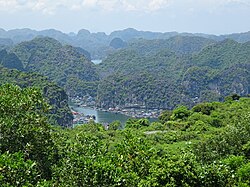
Cát Hải district
District in Haiphong, Vietnam
Cát Hải district Huyện Cát Hải | |
|---|---|
District | |
 | |
 | |
| 20°49′01″N 107°00′00″E / 20.817°N 107.000°E / 20.817; 107.000 | |
| Country |  Vietnam Vietnam |
| Municipality | Haiphong |
| Capital | Cát Bà |
| Area | |
| • Total | 345.31 km2 (133.32 sq mi) |
| Population (2019) | |
| • Total | 32,090 |
| • Density | 93/km2 (240/sq mi) |
Cát Hải is a rural district (huyện) of Hai Phong, the third largest city of Vietnam. It includes the old Cát Bà town since 1977.[1]
As of 2018 the district had a population of 43,187. The districts covers an area of 295 km2 (114 sq mi). The district capital lies at Cát Bà [vi].[2]
The island is subject to major land developments. Vinfast is building an automobile factory on the southern half of the island,[3] and Sun Group is developing a holiday resort on the northern half. A 5.44 km long bridge - the longest sea crossing in Vietnam - connects the island to Hai Phong.
References
- ^ Leontine E. Visser - Challenging Coasts Page 216 2004 "From an administrative point of view, Cat Hai Island belongs to Cat Hai District, which consists of hundreds of islands ... In a spatial as well as an economic sense, the district is dominated by Cat Hai Island and neighbouring Cat Ba Island to ."
- ^ "Districts of Vietnam". Retrieved January 19, 2017.
- ^ "GM forms partnership with Vietnam's VinFast". Financial Times. Archived from the original on 2022-12-24.
External links
 Media related to Cat Hai District at Wikimedia Commons

Districts of the Red River Delta | ||
|---|---|---|
| Hanoi city |
|  |
| Haiphong city |
| |
| Bắc Ninh province | ||
| Hà Nam province | ||
| Hải Dương province |
| |
| Hưng Yên province | ||
| Nam Định province | ||
| Ninh Bình province | ||
| Thái Bình province | ||
| Vĩnh Phúc province |
| |
※ denotes provincial seat. | ||


