Geghamavan
Place in Gegharkunik, Armenia
Geghamavan Գեղամավան | |
|---|---|
 A view of Geghamavan and St. Hovhannes Church | |
40°33′43″N 44°53′15″E / 40.56194°N 44.88750°E / 40.56194; 44.88750 | |
| Country | Armenia |
| Province | Gegharkunik |
| Municipality | Sevan |
| Founded | 1830s |
| Area | |
| • Total | 29.48 km2 (11.38 sq mi) |
| Elevation | 1,842 m (6,043 ft) |
| Population (2011)[1] | |
| • Total | 1,721 |
| • Density | 58/km2 (150/sq mi) |
| Time zone | UTC+4 (AMT) |
| Postal code | 1507 |
| Geghamavan at GEOnet Names Server | |
Geghamavan (Armenian: Գեղամավան) is a village in the Sevan Municipality of the Gegharkunik Province of Armenia.
History
The village was founded in the 1830s by migrants from the Maku region of Persia. There are church/shrine ruins in the eastern part of the village.[2]
Gallery
-
 St. Hovhannes Church
 -
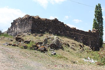
 Ruined church in Geghamavan
 -
 WWII monument
 -
 Cemetery in Geghamavan


References
- ^ Statistical Committee of Armenia. "The results of the 2011 Population Census of Armenia" (PDF).
- ^ Kiesling, Brady; Kojian, Raffi (2005). Rediscovering Armenia: Guide (2nd ed.). Yerevan: Matit Graphic Design Studio. pp. 74–75. ISBN 99941-0-121-8.
External links
Wikimedia Commons has media related to Geghamavan.
- Report of the results of the 2001 Armenian Census, Statistical Committee of Armenia
- Kiesling, Brady (June 2000). Rediscovering Armenia: An Archaeological/Touristic Gazetteer and Map Set for the Historical Monuments of Armenia (PDF). Archived (PDF) from the original on 6 November 2021.
- v
- t
- e
 Gegharkunik Province
Capital: Gavar

- Akhpradzor
- Akunk
- Areguni
- Arpunk
- Avazan
- Ayrk
- Azat
- Daranak
- Geghakar
- Geghamabak
- Geghamasar
- Jaghatsadzor
- Kakhakn
- Karchaghbyur
- Khachaghbyur
- Kut
- Kutakan
- Lchavan
- Lusakunk
- Makenis
- Mets Masrik
- Nerkin Shorzha
- Norabak
- Norakert
- Pambak
- Pokr Masrik
- Shatjrek
- Shatvan
- Sotk
- Torfavan
- Tretuk
- Tsovak
- Vanevan
- Verin Shorzha
- Zariver
Portal:
 Geography

 | This article about a location in Gegharkunik Province, Armenia is a stub. You can help Wikipedia by expanding it. |
- v
- t
- e


