Gundershoffen
You can help expand this article with text translated from the corresponding article in French. (December 2008) Click [show] for important translation instructions.
- View a machine-translated version of the French article.
- Machine translation, like DeepL or Google Translate, is a useful starting point for translations, but translators must revise errors as necessary and confirm that the translation is accurate, rather than simply copy-pasting machine-translated text into the English Wikipedia.
- Do not translate text that appears unreliable or low-quality. If possible, verify the text with references provided in the foreign-language article.
- You must provide copyright attribution in the edit summary accompanying your translation by providing an interlanguage link to the source of your translation. A model attribution edit summary is
Content in this edit is translated from the existing French Wikipedia article at [[:fr:Gundershoffen]]; see its history for attribution. - You may also add the template
{{Translated|fr|Gundershoffen}}to the talk page. - For more guidance, see Wikipedia:Translation.
Commune in Grand Est, France
Gundershoffen Gunderschoffe | ||
|---|---|---|
Commune | ||
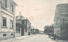 Gundershoffen in or shortly before 1898 | ||
 Coat of arms | ||
Location of Gundershoffen  | ||
(2020–2026) Victor Vogt[1] | | |
| Area 1 | 17.55 km2 (6.78 sq mi) | |
| Population (2021)[2] | 3,779 | |
| • Density | 220/km2 (560/sq mi) | |
| Time zone | UTC+01:00 (CET) | |
| • Summer (DST) | UTC+02:00 (CEST) | |
| INSEE/Postal code | 67176 /67110 | |
| Elevation | 163–261 m (535–856 ft) | |
| 1 French Land Register data, which excludes lakes, ponds, glaciers > 1 km2 (0.386 sq mi or 247 acres) and river estuaries. | ||
Gundershoffen (German: Gundershofen) is a commune in the Bas-Rhin department in Grand Est in north-eastern France.[3]
History
Archaeological finds such as coins, pottery and statues from the third century testify to the presence of a settlement here in the Gallo-Roman period.
The earliest surviving written record of the place dates from 1232, where the name used for the settlement is Guntershoven, a name which endured at least until the seventeenth century.
The village was at one stage owned by the Dukes of Lorraine. Like many villages in Alsace, Gundershoffen was ravaged by the Thirty Years War with savage depopulation resulting: it was subsequently repopulated by families from Switzerland.
In 1940 the Germans recovered Alsace and the little town suffered badly from the fighting of the Second World War. Liberation appeared in the form of the US Army on December 3, 1944, but the area was recaptured by German troops. Only in March 1945 were the German fighters finally expelled.
Population
| Year | Pop. | ±% p.a. |
|---|---|---|
| 1968 | 2,502 | — |
| 1975 | 2,738 | +1.30% |
| 1982 | 3,261 | +2.53% |
| 1990 | 3,377 | +0.44% |
| 1999 | 3,490 | +0.37% |
| 2007 | 3,458 | −0.12% |
| 2012 | 3,586 | +0.73% |
| 2017 | 3,679 | +0.51% |
| Source: INSEE[4] | ||
Landmarks
Gundershoffen possesses an eighteenth-century Protestant church and a modern Catholic one.
The Jewish cemetery dates from the late eighteenth or early nineteenth century, and continues to be used by Gundershoffen and by the neighbouring commune of Reichshoffen.[5]
See also
References
- ^ "Répertoire national des élus: les maires" (in French). data.gouv.fr, Plateforme ouverte des données publiques françaises. 13 September 2022.
- ^ "Populations légales 2021". The National Institute of Statistics and Economic Studies. 28 December 2023.
- ^ INSEE commune file
- ^ Population en historique depuis 1968, INSEE
- ^ Jewish cemetery website (in German, but it has many pictures)
Wikimedia Commons has media related to Gundershoffen.
- v
- t
- e

- Achenheim
- Adamswiller
- Albé
- Alteckendorf
- Altenheim
- Altorf
- Altwiller
- Andlau
- Artolsheim
- Aschbach
- Asswiller
- Avolsheim
- Baerendorf
- Balbronn
- Baldenheim
- Barembach
- Barr
- Bassemberg
- Batzendorf
- Beinheim
- Bellefosse
- Belmont
- Benfeld
- Berg
- Bergbieten
- Bernardswiller
- Bernardvillé
- Bernolsheim
- Berstett
- Berstheim
- Betschdorf
- Bettwiller
- Biblisheim
- Bietlenheim
- Bilwisheim
- Bindernheim
- Bischheim
- Bischholtz
- Bischoffsheim
- Bischwiller
- Bissert
- Bitschhoffen
- Blaesheim
- Blancherupt
- Blienschwiller
- Bœrsch
- Bœsenbiesen
- Bolsenheim
- Boofzheim
- Bootzheim
- Bosselshausen
- Bossendorf
- Bourg-Bruche
- Bourgheim
- Bouxwiller
- Breitenau
- Breitenbach
- Breuschwickersheim
- La Broque
- Brumath
- Buhl
- Burbach
- Bust
- Buswiller
- Butten
- Châtenois
- Cleebourg
- Climbach
- Colroy-la-Roche
- Cosswiller
- Crastatt
- Crœttwiller
- Dachstein
- Dahlenheim
- Dalhunden
- Dambach
- Dambach-la-Ville
- Dangolsheim
- Daubensand
- Dauendorf
- Dehlingen
- Dettwiller
- Diebolsheim
- Diedendorf
- Dieffenbach-au-Val
- Dieffenbach-lès-Wœrth
- Dieffenthal
- Diemeringen
- Dimbsthal
- Dingsheim
- Dinsheim-sur-Bruche
- Domfessel
- Donnenheim
- Dorlisheim
- Dossenheim-Kochersberg
- Dossenheim-sur-Zinsel
- Drachenbronn-Birlenbach
- Drulingen
- Drusenheim
- Duntzenheim
- Duppigheim
- Durningen
- Durrenbach
- Durstel
- Duttlenheim
- Eberbach-Seltz
- Ebersheim
- Ebersmunster
- Eckartswiller
- Eckbolsheim
- Eckwersheim
- Eichhoffen
- Elsenheim
- Engwiller
- Entzheim
- Epfig
- Erckartswiller
- Ergersheim
- Ernolsheim-Bruche
- Ernolsheim-lès-Saverne
- Erstein
- Eschau
- Eschbach
- Eschbourg
- Eschwiller
- Ettendorf
- Eywiller
- Fegersheim
- Fessenheim-le-Bas
- Flexbourg
- Forstfeld
- Forstheim
- Fort-Louis
- Fouchy
- Fouday
- Friedolsheim
- Friesenheim
- Frœschwiller
- Frohmuhl
- Furchhausen
- Furdenheim
- Gambsheim
- Geispolsheim
- Geiswiller-Zœbersdorf
- Gerstheim
- Gertwiller
- Geudertheim
- Gœrlingen
- Gœrsdorf
- Gottenhouse
- Gottesheim
- Gougenheim
- Goxwiller
- Grandfontaine
- Grassendorf
- Grendelbruch
- Gresswiller
- Gries
- Griesheim-près-Molsheim
- Griesheim-sur-Souffel
- Gumbrechtshoffen
- Gundershoffen
- Gungwiller
- Gunstett
- Haegen
- Haguenausubpr
- Handschuheim
- Hangenbieten
- Harskirchen
- Hatten
- Hattmatt
- Hegeney
- Heidolsheim
- Heiligenberg
- Heiligenstein
- Hengwiller
- Herbitzheim
- Herbsheim
- Herrlisheim
- Hessenheim
- Hilsenheim
- Hindisheim
- Hinsbourg
- Hinsingen
- Hipsheim
- Hirschland
- Hochfelden
- Hochstett
- Hœnheim
- Hœrdt
- Hoffen
- Hohengœft
- Hohfrankenheim
- Le Hohwald
- Holtzheim
- Hunspach
- Hurtigheim
- Huttendorf
- Huttenheim
- Ichtratzheim
- Illkirch-Graffenstaden
- Ingenheim
- Ingolsheim
- Ingwiller
- Innenheim
- Issenhausen
- Ittenheim
- Itterswiller
- Jetterswiller
- Kaltenhouse
- Kauffenheim
- Keffenach
- Kertzfeld
- Keskastel
- Kesseldorf
- Kienheim
- Kilstett
- Kindwiller
- Kintzheim
- Kirchheim
- Kirrberg
- Kirrwiller
- Kleingœft
- Knœrsheim
- Kogenheim
- Kolbsheim
- Krautergersheim
- Krautwiller
- Kriegsheim
- Kurtzenhouse
- Kuttolsheim
- Kutzenhausen
- Lalaye
- Lampertheim
- Lampertsloch
- Landersheim
- Langensoultzbach
- Laubach
- Lauterbourg
- Lembach
- Leutenheim
- Lichtenberg
- Limersheim
- Lingolsheim
- Lipsheim
- Littenheim
- Lixhausen
- Lobsann
- Lochwiller
- Lohr
- Lorentzen
- Lupstein
- Lutzelhouse
- Mackenheim
- Mackwiller
- Maennolsheim
- Maisonsgoutte
- Marckolsheim
- Marlenheim
- Marmoutier
- Matzenheim
- Meistratzheim
- Melsheim
- Memmelshoffen
- Menchhoffen
- Merkwiller-Pechelbronn
- Mertzwiller
- Mietesheim
- Minversheim
- Mittelbergheim
- Mittelhausbergen
- Mittelschaeffolsheim
- Mollkirch
- Molsheimsubpr
- Mommenheim
- Monswiller
- Morsbronn-les-Bains
- Morschwiller
- Mothern
- Muhlbach-sur-Bruche
- Mulhausen
- Munchhausen
- Mundolsheim
- Mussig
- Muttersholtz
- Mutzenhouse
- Mutzig
- Natzwiller
- Neewiller-près-Lauterbourg
- Neubois
- Neugartheim-Ittlenheim
- Neuhaeusel
- Neuve-Église
- Neuviller-la-Roche
- Neuwiller-lès-Saverne
- Niederbronn-les-Bains
- Niederhaslach
- Niederhausbergen
- Niederlauterbach
- Niedermodern
- Niedernai
- Niederrœdern
- Niederschaeffolsheim
- Niedersoultzbach
- Niedersteinbach
- Nordheim
- Nordhouse
- Nothalten
- Obenheim
- Oberbronn
- Oberdorf-Spachbach
- Oberhaslach
- Oberhausbergen
- Oberhoffen-lès-Wissembourg
- Oberhoffen-sur-Moder
- Oberlauterbach
- Obermodern-Zutzendorf
- Obernai
- Oberrœdern
- Oberschaeffolsheim
- Obersoultzbach
- Obersteinbach
- Odratzheim
- Oermingen
- Offendorf
- Offwiller
- Ohlungen
- Ohnenheim
- Olwisheim
- Orschwiller
- Osthoffen
- Osthouse
- Ostwald
- Ottersthal
- Otterswiller
- Ottrott
- Ottwiller
- Petersbach
- La Petite-Pierre
- Pfalzweyer
- Pfulgriesheim
- Plaine
- Plobsheim
- Preuschdorf
- Printzheim
- Puberg
- Quatzenheim
- Rangen
- Ranrupt
- Ratzwiller
- Rauwiller
- Reichsfeld
- Reichshoffen
- Reichstett
- Reinhardsmunster
- Reipertswiller
- Retschwiller
- Reutenbourg
- Rexingen
- Rhinau
- Richtolsheim
- Riedseltz
- Rimsdorf
- Ringendorf
- Rittershoffen
- Rœschwoog
- Rohr
- Rohrwiller
- Romanswiller
- Roppenheim
- Rosenwiller
- Rosheim
- Rossfeld
- Rosteig
- Rothau
- Rothbach
- Rott
- Rottelsheim
- Rountzenheim-Auenheim
- Russ
- Saales
- Saasenheim
- Saessolsheim
- Saint-Blaise-la-Roche
- Saint-Jean-Saverne
- Saint-Martin
- Saint-Maurice
- Saint-Nabor
- Saint-Pierre
- Saint-Pierre-Bois
- Salmbach
- Sand
- Sarre-Union
- Sarrewerden
- Saulxures
- Savernesubpr
- Schaeffersheim
- Schaffhouse-près-Seltz
- Schalkendorf
- Scharrachbergheim-Irmstett
- Scheibenhard
- Scherlenheim
- Scherwiller
- Schillersdorf
- Schiltigheim
- Schirmeck
- Schirrhein
- Schirrhoffen
- Schleithal
- Schnersheim
- Schœnau
- Schœnbourg
- Schœnenbourg
- Schopperten
- Schweighouse-sur-Moder
- Schwenheim
- Schwindratzheim
- Schwobsheim
- Seebach
- Sélestatsubpr
- Seltz
- Sermersheim
- Sessenheim
- Siegen
- Siewiller
- Siltzheim
- Solbach
- Sommerau
- Souffelweyersheim
- Soufflenheim
- Soultz-les-Bains
- Soultz-sous-Forêts
- Sparsbach
- Stattmatten
- Steige
- Steinbourg
- Steinseltz
- Still
- Stotzheim
- Strasbourgpref
- Struth
- Stundwiller
- Stutzheim-Offenheim
- Sundhouse
- Surbourg
- Thal-Drulingen
- Thal-Marmoutier
- Thanvillé
- Tieffenbach
- Traenheim
- Triembach-au-Val
- Trimbach
- Truchtersheim
- Uhlwiller
- Uhrwiller
- Urbeis
- Urmatt
- Uttenheim
- Uttenhoffen
- Uttwiller
- Val-de-Moder
- Valff
- La Vancelle
- Vendenheim
- Villé
- Vœllerdingen
- Volksberg
- Wahlenheim
- Walbourg
- Waldersbach
- Waldhambach
- Waldolwisheim
- Waltenheim-sur-Zorn
- Wangen
- Wangenbourg-Engenthal
- La Wantzenau
- Wasselonne
- Weinbourg
- Weislingen
- Weitbruch
- Weiterswiller
- Westhoffen
- Westhouse
- Westhouse-Marmoutier
- Weyer
- Weyersheim
- Wickersheim-Wilshausen
- Wildersbach
- Willgottheim
- Wilwisheim
- Wimmenau
- Windstein
- Wingen
- Wingen-sur-Moder
- Wingersheim-les-Quatre-Bans
- Wintershouse
- Wintzenbach
- Wintzenheim-Kochersberg
- Wisches
- Wissembourg
- Witternheim
- Wittersheim
- Wittisheim
- Wiwersheim
- Wœrth
- Wolfisheim
- Wolfskirchen
- Wolschheim
- Wolxheim
- Zehnacker
- Zeinheim
- Zellwiller
- Zinswiller
- Zittersheim
- pref: prefecture
- subpr: subprefecture
Authority control databases | |
|---|---|
| International |
|
| National |
|
| Other |
|
 | This Bas-Rhin geographical article is a stub. You can help Wikipedia by expanding it. |
- v
- t
- e


