Ittenheim
You can help expand this article with text translated from the corresponding article in French. (December 2008) Click [show] for important translation instructions.
- View a machine-translated version of the French article.
- Machine translation, like DeepL or Google Translate, is a useful starting point for translations, but translators must revise errors as necessary and confirm that the translation is accurate, rather than simply copy-pasting machine-translated text into the English Wikipedia.
- Do not translate text that appears unreliable or low-quality. If possible, verify the text with references provided in the foreign-language article.
- You must provide copyright attribution in the edit summary accompanying your translation by providing an interlanguage link to the source of your translation. A model attribution edit summary is
Content in this edit is translated from the existing French Wikipedia article at [[:fr:Ittenheim]]; see its history for attribution. - You may also add the template
{{Translated|fr|Ittenheim}}to the talk page. - For more guidance, see Wikipedia:Translation.
Commune in Grand Est, France
Ittenheim Ittene | ||
|---|---|---|
Commune | ||
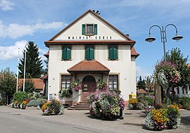 The town hall and school in Ittenheim | ||
 Coat of arms | ||
Location of Ittenheim  | ||
(2020–2026) Alain Grosskost[1] | | |
| Area 1 | 6.71 km2 (2.59 sq mi) | |
| Population (2021)[2] | 2,093 | |
| • Density | 310/km2 (810/sq mi) | |
| Time zone | UTC+01:00 (CET) | |
| • Summer (DST) | UTC+02:00 (CEST) | |
| INSEE/Postal code | 67226 /67117 | |
| Elevation | 152–212 m (499–696 ft) | |
| 1 French Land Register data, which excludes lakes, ponds, glaciers > 1 km2 (0.386 sq mi or 247 acres) and river estuaries. | ||
Ittenheim (French pronunciation: [itənaim] ⓘ; Alsatian: Ittene) is a commune in the Bas-Rhin department in Grand Est in north-eastern France.[3]
Geography
Ittenheim is positioned ten kilometres (six miles) to the west of Strasbourg. The little town is crossed by the departmental road RD1004 (formerly Route Nationale 4): before the development of the autoroute network, Ittenheim was the first village passed through by motorists after leaving Strasbourg en route for Paris.
Adjacent communes are Hurtigheim to the north and Handschuheim to the west.
Population
| Year | Pop. | ±% p.a. |
|---|---|---|
| 1968 | 911 | — |
| 1975 | 1,060 | +2.19% |
| 1982 | 1,230 | +2.15% |
| 1990 | 1,594 | +3.29% |
| 1999 | 1,904 | +1.99% |
| 2007 | 2,144 | +1.50% |
| 2012 | 2,170 | +0.24% |
| 2017 | 2,111 | −0.55% |
| Source: INSEE[4] | ||
Celebrity connection
One of the inhabitants of Ittenheim may have saved the life of President Jacques Chirac during the 2002 Bastille Day parade. Chirac was targeted by a right-wing extremist gunman named Maxime Brunerie: the man who disarmed the gunman, thereby thwarting a presidential assassination, is called Jacques Weber.
See also
References
- ^ "Répertoire national des élus: les maires" (in French). data.gouv.fr, Plateforme ouverte des données publiques françaises. 13 September 2022.
- ^ "Populations légales 2021". The National Institute of Statistics and Economic Studies. 28 December 2023.
- ^ INSEE commune file
- ^ Population en historique depuis 1968, INSEE
Wikimedia Commons has media related to Ittenheim.
- v
- t
- e

- Achenheim
- Adamswiller
- Albé
- Alteckendorf
- Altenheim
- Altorf
- Altwiller
- Andlau
- Artolsheim
- Aschbach
- Asswiller
- Avolsheim
- Baerendorf
- Balbronn
- Baldenheim
- Barembach
- Barr
- Bassemberg
- Batzendorf
- Beinheim
- Bellefosse
- Belmont
- Benfeld
- Berg
- Bergbieten
- Bernardswiller
- Bernardvillé
- Bernolsheim
- Berstett
- Berstheim
- Betschdorf
- Bettwiller
- Biblisheim
- Bietlenheim
- Bilwisheim
- Bindernheim
- Bischheim
- Bischholtz
- Bischoffsheim
- Bischwiller
- Bissert
- Bitschhoffen
- Blaesheim
- Blancherupt
- Blienschwiller
- Bœrsch
- Bœsenbiesen
- Bolsenheim
- Boofzheim
- Bootzheim
- Bosselshausen
- Bossendorf
- Bourg-Bruche
- Bourgheim
- Bouxwiller
- Breitenau
- Breitenbach
- Breuschwickersheim
- La Broque
- Brumath
- Buhl
- Burbach
- Bust
- Buswiller
- Butten
- Châtenois
- Cleebourg
- Climbach
- Colroy-la-Roche
- Cosswiller
- Crastatt
- Crœttwiller
- Dachstein
- Dahlenheim
- Dalhunden
- Dambach
- Dambach-la-Ville
- Dangolsheim
- Daubensand
- Dauendorf
- Dehlingen
- Dettwiller
- Diebolsheim
- Diedendorf
- Dieffenbach-au-Val
- Dieffenbach-lès-Wœrth
- Dieffenthal
- Diemeringen
- Dimbsthal
- Dingsheim
- Dinsheim-sur-Bruche
- Domfessel
- Donnenheim
- Dorlisheim
- Dossenheim-Kochersberg
- Dossenheim-sur-Zinsel
- Drachenbronn-Birlenbach
- Drulingen
- Drusenheim
- Duntzenheim
- Duppigheim
- Durningen
- Durrenbach
- Durstel
- Duttlenheim
- Eberbach-Seltz
- Ebersheim
- Ebersmunster
- Eckartswiller
- Eckbolsheim
- Eckwersheim
- Eichhoffen
- Elsenheim
- Engwiller
- Entzheim
- Epfig
- Erckartswiller
- Ergersheim
- Ernolsheim-Bruche
- Ernolsheim-lès-Saverne
- Erstein
- Eschau
- Eschbach
- Eschbourg
- Eschwiller
- Ettendorf
- Eywiller
- Fegersheim
- Fessenheim-le-Bas
- Flexbourg
- Forstfeld
- Forstheim
- Fort-Louis
- Fouchy
- Fouday
- Friedolsheim
- Friesenheim
- Frœschwiller
- Frohmuhl
- Furchhausen
- Furdenheim
- Gambsheim
- Geispolsheim
- Geiswiller-Zœbersdorf
- Gerstheim
- Gertwiller
- Geudertheim
- Gœrlingen
- Gœrsdorf
- Gottenhouse
- Gottesheim
- Gougenheim
- Goxwiller
- Grandfontaine
- Grassendorf
- Grendelbruch
- Gresswiller
- Gries
- Griesheim-près-Molsheim
- Griesheim-sur-Souffel
- Gumbrechtshoffen
- Gundershoffen
- Gungwiller
- Gunstett
- Haegen
- Haguenausubpr
- Handschuheim
- Hangenbieten
- Harskirchen
- Hatten
- Hattmatt
- Hegeney
- Heidolsheim
- Heiligenberg
- Heiligenstein
- Hengwiller
- Herbitzheim
- Herbsheim
- Herrlisheim
- Hessenheim
- Hilsenheim
- Hindisheim
- Hinsbourg
- Hinsingen
- Hipsheim
- Hirschland
- Hochfelden
- Hochstett
- Hœnheim
- Hœrdt
- Hoffen
- Hohengœft
- Hohfrankenheim
- Le Hohwald
- Holtzheim
- Hunspach
- Hurtigheim
- Huttendorf
- Huttenheim
- Ichtratzheim
- Illkirch-Graffenstaden
- Ingenheim
- Ingolsheim
- Ingwiller
- Innenheim
- Issenhausen
- Ittenheim
- Itterswiller
- Jetterswiller
- Kaltenhouse
- Kauffenheim
- Keffenach
- Kertzfeld
- Keskastel
- Kesseldorf
- Kienheim
- Kilstett
- Kindwiller
- Kintzheim
- Kirchheim
- Kirrberg
- Kirrwiller
- Kleingœft
- Knœrsheim
- Kogenheim
- Kolbsheim
- Krautergersheim
- Krautwiller
- Kriegsheim
- Kurtzenhouse
- Kuttolsheim
- Kutzenhausen
- Lalaye
- Lampertheim
- Lampertsloch
- Landersheim
- Langensoultzbach
- Laubach
- Lauterbourg
- Lembach
- Leutenheim
- Lichtenberg
- Limersheim
- Lingolsheim
- Lipsheim
- Littenheim
- Lixhausen
- Lobsann
- Lochwiller
- Lohr
- Lorentzen
- Lupstein
- Lutzelhouse
- Mackenheim
- Mackwiller
- Maennolsheim
- Maisonsgoutte
- Marckolsheim
- Marlenheim
- Marmoutier
- Matzenheim
- Meistratzheim
- Melsheim
- Memmelshoffen
- Menchhoffen
- Merkwiller-Pechelbronn
- Mertzwiller
- Mietesheim
- Minversheim
- Mittelbergheim
- Mittelhausbergen
- Mittelschaeffolsheim
- Mollkirch
- Molsheimsubpr
- Mommenheim
- Monswiller
- Morsbronn-les-Bains
- Morschwiller
- Mothern
- Muhlbach-sur-Bruche
- Mulhausen
- Munchhausen
- Mundolsheim
- Mussig
- Muttersholtz
- Mutzenhouse
- Mutzig
- Natzwiller
- Neewiller-près-Lauterbourg
- Neubois
- Neugartheim-Ittlenheim
- Neuhaeusel
- Neuve-Église
- Neuviller-la-Roche
- Neuwiller-lès-Saverne
- Niederbronn-les-Bains
- Niederhaslach
- Niederhausbergen
- Niederlauterbach
- Niedermodern
- Niedernai
- Niederrœdern
- Niederschaeffolsheim
- Niedersoultzbach
- Niedersteinbach
- Nordheim
- Nordhouse
- Nothalten
- Obenheim
- Oberbronn
- Oberdorf-Spachbach
- Oberhaslach
- Oberhausbergen
- Oberhoffen-lès-Wissembourg
- Oberhoffen-sur-Moder
- Oberlauterbach
- Obermodern-Zutzendorf
- Obernai
- Oberrœdern
- Oberschaeffolsheim
- Obersoultzbach
- Obersteinbach
- Odratzheim
- Oermingen
- Offendorf
- Offwiller
- Ohlungen
- Ohnenheim
- Olwisheim
- Orschwiller
- Osthoffen
- Osthouse
- Ostwald
- Ottersthal
- Otterswiller
- Ottrott
- Ottwiller
- Petersbach
- La Petite-Pierre
- Pfalzweyer
- Pfulgriesheim
- Plaine
- Plobsheim
- Preuschdorf
- Printzheim
- Puberg
- Quatzenheim
- Rangen
- Ranrupt
- Ratzwiller
- Rauwiller
- Reichsfeld
- Reichshoffen
- Reichstett
- Reinhardsmunster
- Reipertswiller
- Retschwiller
- Reutenbourg
- Rexingen
- Rhinau
- Richtolsheim
- Riedseltz
- Rimsdorf
- Ringendorf
- Rittershoffen
- Rœschwoog
- Rohr
- Rohrwiller
- Romanswiller
- Roppenheim
- Rosenwiller
- Rosheim
- Rossfeld
- Rosteig
- Rothau
- Rothbach
- Rott
- Rottelsheim
- Rountzenheim-Auenheim
- Russ
- Saales
- Saasenheim
- Saessolsheim
- Saint-Blaise-la-Roche
- Saint-Jean-Saverne
- Saint-Martin
- Saint-Maurice
- Saint-Nabor
- Saint-Pierre
- Saint-Pierre-Bois
- Salmbach
- Sand
- Sarre-Union
- Sarrewerden
- Saulxures
- Savernesubpr
- Schaeffersheim
- Schaffhouse-près-Seltz
- Schalkendorf
- Scharrachbergheim-Irmstett
- Scheibenhard
- Scherlenheim
- Scherwiller
- Schillersdorf
- Schiltigheim
- Schirmeck
- Schirrhein
- Schirrhoffen
- Schleithal
- Schnersheim
- Schœnau
- Schœnbourg
- Schœnenbourg
- Schopperten
- Schweighouse-sur-Moder
- Schwenheim
- Schwindratzheim
- Schwobsheim
- Seebach
- Sélestatsubpr
- Seltz
- Sermersheim
- Sessenheim
- Siegen
- Siewiller
- Siltzheim
- Solbach
- Sommerau
- Souffelweyersheim
- Soufflenheim
- Soultz-les-Bains
- Soultz-sous-Forêts
- Sparsbach
- Stattmatten
- Steige
- Steinbourg
- Steinseltz
- Still
- Stotzheim
- Strasbourgpref
- Struth
- Stundwiller
- Stutzheim-Offenheim
- Sundhouse
- Surbourg
- Thal-Drulingen
- Thal-Marmoutier
- Thanvillé
- Tieffenbach
- Traenheim
- Triembach-au-Val
- Trimbach
- Truchtersheim
- Uhlwiller
- Uhrwiller
- Urbeis
- Urmatt
- Uttenheim
- Uttenhoffen
- Uttwiller
- Val-de-Moder
- Valff
- La Vancelle
- Vendenheim
- Villé
- Vœllerdingen
- Volksberg
- Wahlenheim
- Walbourg
- Waldersbach
- Waldhambach
- Waldolwisheim
- Waltenheim-sur-Zorn
- Wangen
- Wangenbourg-Engenthal
- La Wantzenau
- Wasselonne
- Weinbourg
- Weislingen
- Weitbruch
- Weiterswiller
- Westhoffen
- Westhouse
- Westhouse-Marmoutier
- Weyer
- Weyersheim
- Wickersheim-Wilshausen
- Wildersbach
- Willgottheim
- Wilwisheim
- Wimmenau
- Windstein
- Wingen
- Wingen-sur-Moder
- Wingersheim-les-Quatre-Bans
- Wintershouse
- Wintzenbach
- Wintzenheim-Kochersberg
- Wisches
- Wissembourg
- Witternheim
- Wittersheim
- Wittisheim
- Wiwersheim
- Wœrth
- Wolfisheim
- Wolfskirchen
- Wolschheim
- Wolxheim
- Zehnacker
- Zeinheim
- Zellwiller
- Zinswiller
- Zittersheim
- pref: prefecture
- subpr: subprefecture
Authority control databases | |
|---|---|
| International |
|
| National |
|
 | This Bas-Rhin geographical article is a stub. You can help Wikipedia by expanding it. |
- v
- t
- e


