Jayantipur
Village in West Bengal, India
22°43′51″N 87°32′24″E / 22.7307°N 87.5401°E / 22.7307; 87.5401 India
India (2011)
721201
Jayantipur is a village in the Chandrakona II CD block in the Ghatal subdivision of the Paschim Medinipur district in the state of West Bengal, India.
Geography


8km
5miles
5miles

Rupnarayan River
Uttar Bar
H

Radhanagar
H
Radhakantapur
H
Palashpai
H
Narajole
HV
Laoda
H
Lachhipur
H
Kotalpur
H
Jayantipur
H
Jalshara
H
Iswarpur
H
Gobindanagar
H
Gangadaspur
H
Dihi Baliharpur
H
Chaipat
H
Baikunthapur
H
Alui
H
Ajuria
H
Birsingha
R
Sonakhali
R
Daspur
R
Ramjibanpur
M
Khirpai
M
Kharar
M
Ghatal
M
Chandrakona
M
Cities and towns in Ghatal subdivision of Paschim Medinipur district
M: municipal city/ town, R: rural/ urban centre, H: historical/ religious centre
Owing to space constraints in the small map, the actual locations in a larger map may vary slightly
M: municipal city/ town, R: rural/ urban centre, H: historical/ religious centre
Owing to space constraints in the small map, the actual locations in a larger map may vary slightly
Location
Jayantipur is located at 22°43′51″N 87°32′24″E / 22.7307°N 87.5401°E / 22.7307; 87.5401.
Area overview
Ishwar Chandra Vidyasagar, scholar, social reformer and a key figure of the Bengal Renaissance, was born at Birsingha on 26 September 1820.[1][2]
Ghatal subdivision, shown in the map alongside, has alluvial soils. Around 85% of the total cultivated area is cropped more than once.[3] It has a density of population of 1,099 per km2, but being a small subdivision only a little over a fifth of the people in the district reside in this subdivision. 14.33% of the population lives in urban areas and 86.67% lives in the rural areas.[4]
Note: The map alongside presents some of the notable locations in the subdivision. All places marked in the map are linked in the larger full screen map.
Demographics
According to the 2011 Census of India, Jayantipur had a total population of 613, of which 324 (53%) were males and 289 (47%) were females. There were 59 persons in the age range of 0–6 years. The total number of literate persons in Jayantipur was 497 (89.71% of the population over 6 years).[5]
Culture
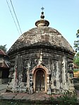
David J. McCutchion mentions the pancha-ratna temple as having octagonal corner towers with square centre tower.[6]
Jayantipur picture gallery
-
 Pancha-ratna Shyamachandrajiu temple
 -
 Terracotta decorations in Shyamachandrajiu temple
 -
 Terracotta decorations in Shyamachandrajiu temple
 -
 Terracotta decorations in Shyamachandrajiu temple
 -
 Char-chala Radha Rasiknagarjiu temple


References
- ^ Murshid, Ghulam. "Vidyasagar, Pundit Iswar Chandra". Banglapedia. Retrieved 24 July 2016.
- ^ "Ishwar Chandra Vidyasagar". www.whereincity.com. Archived from the original on 25 December 2018. Retrieved 24 July 2016.
- ^ "District Human Development Report Paschim Medinipur, 2011". page 27-28. Department of Planning and Statistics, Government of West Bengal. Retrieved 10 September 2020.
- ^ "District Statistical Handbook Paschim Medinipur, 2013". Table 2.2, 2.4 (a). Department of Planning and Statistics. Retrieved 10 September 2020.
- ^ "CD block Wise Primary Census Abstract Data(PCA)". West Bengal – District-wise CD blocks. Registrar General and Census, India. Retrieved 25 August 2020.
- ^ McCutchion, David J., Late Mediaeval Temples of Bengal, first published 1972, reprinted 2017, page 44-45. The Asiatic Society, Kolkata, ISBN 978-93-81574-65-2
External links
Wikimedia Commons has media related to Jayantipur, Chandrakona II CD block.
- v
- t
- e
Cities, towns and locations in Paschim Medinipur District, Medinipur division
and census towns
| Kharagpur subdivision | |
|---|---|
| Medinipur Sadar subdivision | |
| Ghatal subdivision |

other than cities and towns
 Paschim Medinipur topics
 People from Paschim Medinipur district
- Villages in Paschim Medinipur district


 India portal
 | This article about a location in the Paschim Medinipur district of West Bengal is a stub. You can help Wikipedia by expanding it. |
- v
- t
- e


