Kerur, Paschim Medinipur
Village in West Bengal, India
22°11′10″N 87°40′08″E / 22.1862°N 87.6688°E / 22.1862; 87.6688 India
India (2011)
721155
Kerur is a village in the Sabang CD block in the Kharagpur subdivision of the Paschim Medinipur district in the state of West Bengal, India.
Geography


8km
5miles
5miles

O
D
I
S
H
A
Adasimla
H

Tilantapara
H
Shrirampur
H
Kolanda
H
Kerur
H
Dubrajpur
H
Bhemwa
H
Kurumbera Fort
H
Moghalmari
H
Sabang
R
Narayangarh
R
Mohanpur
R
Lutunia
R
Khandrui
R
Keshiary
R
Kashmuli
R
Dhaneswarpur
R
Dantan
R
Belda
R
Deuli
CT
Chaulia
CT
Cities and towns in the southern portion of Kharagpur subdivision (including Dantan I & II, Mohanpur, Keshiary, Narayangarh and Sabang CD blocks) of Paschim Medinipur district
CT: census town, R: rural/ urban centre, H: historical/ religious centre
Owing to space constraints in the small map, the actual locations in a larger map may vary slightly
CT: census town, R: rural/ urban centre, H: historical/ religious centre
Owing to space constraints in the small map, the actual locations in a larger map may vary slightly
Location
Kerur is located at 22°11′10″N 87°40′08″E / 22.1862°N 87.6688°E / 22.1862; 87.6688.
Area overview
Kharagpur subdivision, shown partly in the map alongside, mostly has alluvial soils, except in two CD blocks in the west – Kharagpur I and Keshiary, which mostly have lateritic soils. Around 74% of the total cultivated area is cropped more than once.[1] With a density of population of 787 per km2nearly half of the district's population resides in this subdivision. 14.33% of the population lives in urban areas and 86.67% lives in the rural areas.[2]
Note: The map alongside presents some of the notable locations in the subdivision. All places marked in the map are linked in the larger full screen map.
Demographics
According to the 2011 Census of India, Kerur had a total population of 1,652, of which 847 (51%) were males and 805 (51%) were females. There were 200 persons in the age range of 0–6 years. The total number of literate persons in Kerur was 1,258 (86.64% of the population over 6 years).[3]
.*For language details see Sabang (community development block)#Language and religion
Education
Kerur High School is a Bengali-medium co-educational institution established in 1970. It has facilities for teaching from class V to class X. It has a library with 594 books, 10 computers and a playground.[4]
Kerur picture gallery
-
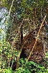 Baikunthanath deul
 -
 Baikunthanath deul


References
- ^ "District Human Development Report Paschim Medinipur, 2011". page 27-28. Department of Planning and Statistics, Government of West Bengal. Retrieved 10 September 2020.
- ^ "District Statistical Handbook Paschim Medinipur, 2013". Table 2.2, 2.4 (a). Department of Planning and Statistics. Retrieved 10 September 2020.
- ^ "CD block Wise Primary Census Abstract Data(PCA)". West Bengal – District-wise CD blocks. Registrar General and Census, India. Retrieved 19 August 2020.
- ^ "Kerur High School U Pry". Schools.org. Retrieved 19 August 2020.
External links
Wikimedia Commons has media related to Kerur, Sabang CD block.
- v
- t
- e
Cities, towns and locations in Paschim Medinipur District, Medinipur division
and census towns
| Kharagpur subdivision | |
|---|---|
| Medinipur Sadar subdivision | |
| Ghatal subdivision |

other than cities and towns
 Paschim Medinipur topics
 People from Paschim Medinipur district
- Villages in Paschim Medinipur district


 India portal
 | This article about a location in the Paschim Medinipur district of West Bengal is a stub. You can help Wikipedia by expanding it. |
- v
- t
- e


