Khenchela Province
Province of Algeria
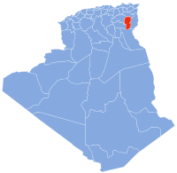
Province in Algeria
Khenchela Province ولاية خنشلة | |
|---|---|
Province | |
 | |
| Nickname: Hansala | |
 | |
| Coordinates: 35°26′02″N 7°08′49″E / 35.434°N 7.147°E / 35.434; 7.147 | |
| Country |  Algeria Algeria |
| Capital | Khenchela |
| Area | |
| • Total | 9,715 km2 (3,751 sq mi) |
| Population (2008)[1] | |
| • Total | 384,268 |
| • Density | 40/km2 (100/sq mi) |
| Time zone | UTC+01 (CET) |
| Area Code | +213 (0) 032 |
| ISO 3166 code | DZ-40 |
| Districts | 8 |
| Municipalities | 21 |
Khenchela Province (Arabic: ولاية خنشلة) is a province (wilaya) in the Aures region in Algeria.
History
The province was created from parts of Oum el Bouaghi Province and Tébessa Province in 1984.
Administrative division
The province is divided into 8 districts, which are further divided into 21 communes or municipalities.
Districts
- Khenchela, as a district and capital Khenchela
- Aïn Touila, located 20 kilometres (12 mi) northeast of the capital
- Babar, located 30 kilometres (19 mi) south of the capital
- Bouhmama, located 35 kilometres (22 mi) west of the capital
- Chechar, located 50 kilometres (31 mi) south of the capital
- El Hamma, located 7 kilometres (4.3 mi) west of the capital
- Kaïs, located 22 kilometres (14 mi) west of the capital
- Ouled Rechache, located 22 kilometres (14 mi) east of the capital
Communes
References
 Algeria portal

Wikimedia Commons has media related to Khenchela Province.
- ^ Office National des Statistiques, Recensement General de la Population et de l’Habitat 2008 Archived 2008-07-24 at the Wayback Machine Preliminary results of the 2008 population census. Accessed on 2008-07-02.
- v
- t
- e
Khenchela ProvinceCapital: Khenchela
| ||
|---|---|---|
|  | |
 | This article about a location in Khenchela Province is a stub. You can help Wikipedia by expanding it. |
- v
- t
- e


