LS postcode area

Postcode area within the United Kingdom

53°49′23″N 1°33′14″W / 53.823°N 1.554°W / 53.823; -1.554CountryUnited KingdomPostcode area
LS
Postcode area name
Leeds
Post towns6Postcode districts32Postcode sectors150Postcodes (live)21,561Postcodes (total)31,805Statistics as at May 2020[1]

The LS postcode area, also known as the Leeds postcode area,[2] is a group of 29 postcode districts in England, within six post towns. These cover northern West Yorkshire (including Leeds, Wetherby, Pudsey, Otley and Ilkley) and some parts of North Yorkshire (including Tadcaster).

Coverage

The approximate coverage of the postcode districts:

Postcode district Post town Coverage Local authority area(s)
LS1 LEEDS Leeds city centre Leeds
LS2 LEEDS Leeds city centre, Woodhouse Leeds
LS3 LEEDS Burley, Woodhouse Leeds
LS4 LEEDS Burley, Kirkstall Leeds
LS5 LEEDS Hawksworth, Kirkstall Leeds
LS6 LEEDS Beckett Park, Burley, Headingley, Hyde Park, Meanwood, Woodhouse Leeds
LS7 LEEDS Beck Hill, Buslingthorpe, Chapel Allerton, Chapeltown, Little London, Lovell Park, Meanwood, Miles Hill, Potternewton, Scott Hall, Sheepscar Leeds
LS8 LEEDS Fearnville, Gipton, Gledhow, Harehills, Oakwood, Roundhay, Moortown, Leeds
LS9 LEEDS Burmantofts, Cross Green, East End Park, Gipton, Harehills, Mabgate, Osmondthorpe, Richmond Hill, Halton Moor Leeds
LS10 LEEDS Belle Isle, Hunslet, Leeds city centre, Middleton, Stourton Leeds
LS11 LEEDS Leeds city centre, Beeston, Beeston Hill, Cottingley, Holbeck Leeds
LS12 LEEDS Armley, Farnley, New Farnley, Wortley Leeds
LS13 LEEDS Bramley, Gamble Hill, Moorside, Rodley, Swinnow Leeds
LS14 LEEDS Fearnville, Killingbeck, Seacroft, Scarcroft, Swarcliffe, Thorner, Whinmoor Leeds
LS15 LEEDS Austhorpe, Barwick-in-Elmet, Colton, Cross Gates, Halton, Halton Moor, Manston, Pendas Fields, Scholes, Temple Newsam, Whitkirk, Killingbeck, Swarcliffe Leeds
LS16 LEEDS Adel, Bramhope, Cookridge, Eccup, Far Headingley, Holt Park, Ireland Wood, Lawnswood, Moor Grange, Tinshill, Weetwood, West Park Leeds
LS17 LEEDS Alwoodley, Bardsey, East Keswick, Eccup, Harewood, Moortown, Shadwell, Slaid Hill, Weardley, Wike Leeds, North Yorkshire
LS18 LEEDS Horsforth Leeds
LS19 LEEDS Carlton, Rawdon, Yeadon Leeds
LS20 LEEDS Guiseley, Hawksworth Leeds
LS21 OTLEY Arthington, Otley, Pool, Blubberhouses Leeds, North Yorkshire
LS22 WETHERBY Collingham, Linton, Wetherby Leeds, North Yorkshire
LS23 WETHERBY Boston Spa, Bramham, Clifford, Thorp Arch, Walton Leeds, North Yorkshire
LS24 TADCASTER Saxton, Stutton, Ulleskelf, Church Fenton, Oxton, Tadcaster, Toulston, Wighill, Ryther cum Ossendyke North Yorkshire
LS25 LEEDS Aberford, Garforth, Hillam, Kippax, Ledsham, Micklefield, Monk Fryston, Sherburn-in-Elmet, South Milford Leeds, North Yorkshire
LS26 LEEDS Great Preston, Methley, Mickletown, Oulton, Rothwell, Swillington, Woodlesford Leeds
LS27 LEEDS Churwell, Gildersome, Morley Leeds
LS28 PUDSEY Bagley, Calverley, Farsley, Fulneck, Pudsey, Stanningley Leeds
LS29 ILKLEY Addingham, Ben Rhydding, Burley in Wharfedale, Burley Woodhead, Denton, Ilkley, Menston, Middleton Bradford, Leeds, North Yorkshire
LS88 LEEDS Jobcentre Plus Non-geographic
LS98 LEEDS First Direct Non-geographic
LS99 LEEDS PO Boxes Non-geographic

Map

KML file (edit • help)
Template:Attached KML/LS postcode area
KML is from Wikidata
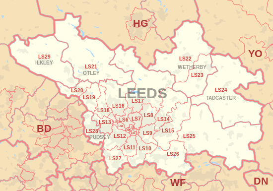
LS postcode area map, showing postcode districts, post towns and neighbouring postcode areas.BD postcode areaDN postcode areaHD postcode areaHG postcode areaHX postcode areaWF postcode areaYO postcode area
LS postcode area map, showing postcode districts in red and post towns in grey text, with links to nearby BD, DN, HG, WF and YO postcode areas.
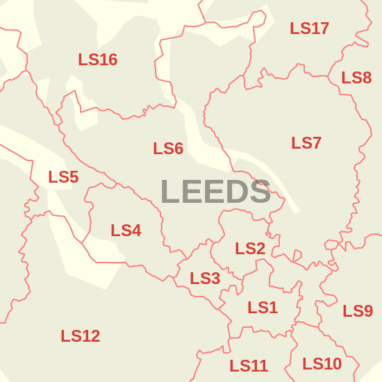
Detailed map of postcode districts in central Leeds

See also

References

  1. ^ "ONS Postcode Directory Version Notes" (ZIP). National Statistics Postcode Products. Office for National Statistics. May 2020. Table 2. Retrieved 19 June 2020. Coordinates from mean of unit postcode points, "Code-Point Open". OS OpenData. Ordnance Survey. February 2012. Retrieved 21 April 2012.
  2. ^ Royal Mail, Address Management Guide, (2004)

External links

  • Royal Mail's Postcode Address File
  • A quick introduction to Royal Mail's Postcode Address File (PAF)
  • v
  • t
  • e
Crown dependencies
Overseas territoriesNon-geographic
  • v
  • t
  • e
Topics
Events
Culture
Music
Other
Politics
Local government
Parliamentary
Transport
Roads
Buses
Railway
Open stations
Lines and
infrastructure
Other
Sport
Football
Rugby
Cricket
Other
Parks, gardens & squares
Areas
  • Category