NP postcode area
Postcode area within the United Kingdom
51°41′06″N 3°01′08″W / 51.685°N 3.019°W / 51.685; -3.019
NP
Newport
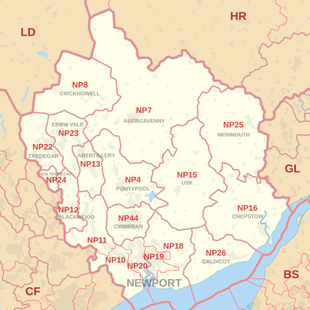
The NP postcode area, also known as the Newport postcode area,[2] is a group of eighteen postcode districts, which are subdivisions of fourteen post towns. These cover south-east Wales, including Newport, Pontypool, Abergavenny, Monmouth, Chepstow, Abertillery, Usk, Tredegar, New Tredegar, Ebbw Vale, Crickhowell, Blackwood, Caldicot and Cwmbran, plus a small part of the English counties of Gloucestershire and Herefordshire.
Coverage
The approximate coverage of the postcode districts:
| Postcode district | Post town | Coverage | Local authority area(s) |
|---|---|---|---|
| NP4 | PONTYPOOL | Pontypool, Blaenavon, Little Mill, Griffithstown, parts of Glascoed | Torfaen, Monmouthshire |
| NP7 | ABERGAVENNY | Abergavenny | Monmouthshire, Herefordshire, Powys |
| NP8 | CRICKHOWELL | Crickhowell , Ffawyddog | Powys |
| NP10 | NEWPORT | Western Newport, including Bassaleg, Duffryn, Rogerstone, Coedkernew, St Brides | Newport |
| NP11 | NEWPORT | North-western Newport, including: Abercarn, Crumlin, Cwmfelinfach, Risca, Ynysddu | Caerphilly |
| NP12 | BLACKWOOD | Blackwood, Pontllanfraith, Wyllie | Caerphilly |
| NP13 | ABERTILLERY | Abertillery | Blaenau Gwent |
| NP15 | USK | Usk, Raglan | Monmouthshire |
| NP16 | CHEPSTOW | Chepstow, Sedbury, Beachley | Monmouthshire, Forest of Dean |
| NP18 | NEWPORT | Eastern Newport, including Caerleon, Langstone, Llanwern, Nash, Llandegveth Underwood | Newport, Monmouthshire, Torfaen |
| NP19 | NEWPORT | Eastern and East Central Newport, including: Beechwood, Maindee, St. Julians, Ringland | Newport |
| NP20 | NEWPORT | Western and West Central Newport, including: City centre, Pill, Maesglas, Crindau, Malpas, Bettws | Newport |
| NP22 | TREDEGAR | Tredegar, Rhymney | Blaenau Gwent, Caerphilly |
| NP23 | EBBW VALE | Ebbw Vale, Brynmawr, Cwm | Blaenau Gwent |
| NP24 | NEW TREDEGAR | New Tredegar | Caerphilly |
| NP25 | MONMOUTH | Monmouth, Wyesham, Redbrook, Welsh Newton | Monmouthshire, Forest of Dean, Herefordshire |
| NP26 | CALDICOT | Caldicot, Magor, Newport | Monmouthshire, Newport |
| NP44 | CWMBRAN | Cwmbran | Torfaen |
Map
KML file (edit • help)
Template:Attached KML/NP postcode area
KML is from Wikidata
See also
References
- ^ "ONS Postcode Directory Version Notes" (ZIP). National Statistics Postcode Products. Office for National Statistics. May 2020. Table 2. Retrieved 19 June 2020. Coordinates from mean of unit postcode points, "Code-Point Open". OS OpenData. Ordnance Survey. February 2012. Retrieved 21 April 2012.
- ^ Royal Mail, Address Management Guide, (2004)
External links
- Royal Mail's Postcode Address File
- A quick introduction to Royal Mail's Postcode Address File (PAF)
- Using Welsh alternative addresses within Royal Mail's Postcode Address File (PAF)
- v
- t
- e
- AB
- AL
- B
- BA
- BB
- BD
- BH
- BL
- BN
- BR
- BS
- BT
- CA
- CB
- CF
- CH
- CM
- CO
- CR
- CT
- CV
- CW
- DA
- DD
- DE
- DG
- DH
- DL
- DN
- DT
- DY
- E
- EC
- EH
- EN
- EX
- FK
- FY
- G
- GL
- GU
- HA
- HD
- HG
- HP
- HR
- HS
- HU
- HX
- IG
- IP
- IV
- KA
- KT
- KW
- KY
- L
- LA
- LD
- LE
- LL
- LN
- LS
- LU
- M
- ME
- MK
- ML
- N
- NE
- NG
- NN
- NP
- NR
- NW
- OL
- OX
- PA
- PE
- PH
- PL
- PO
- PR
- RG
- RH
- RM
- S
- SA
- SE
- SG
- SK
- SL
- SM
- SN
- SO
- SP
- SR
- SS
- ST
- SW
- SY
- TA
- TD
- TF
- TN
- TQ
- TR
- TS
- TW
- UB
- W
- WA
- WC
- WD
- WF
- WN
- WR
- WS
- WV
- YO
- ZE
- Related UK lists: Postcode districts
- Post towns
- Postal counties
- London postal district


