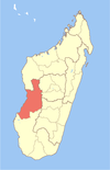
Miandrivazo (district)
District in Madagascar
19°10′44″S 45°23′14″E / 19.1789°S 45.3872°E / -19.1789; 45.3872 Madagascar
 (2020)
Miandrivazo is a district of Menabe in Madagascar.[1][2] It is crossed by the Manambolo River. The district has an area of 12,330 km2 (4,760 sq mi), and the estimated population in 2020 was 162,462.[3]
Communes
The district is further divided into 15 communes:
- Ambatolahy
- Ampanihy
- Ankavandra
- Ankondromena
- Ankotrofotsy
- Anosimena
- Bemahatazana
- Betsipolitra
- Dabolava
- Isalo
- Itondy
- Manambina
- Manandaza
- Miandrivazo
- Soaloka
Rivers
References
- ^ REPOBLIKAN’I MADAGASIKARA:Tanindrazana – Fahafahana – Fandrosoana (PDF). MINISTERE DE L’AGRICULTURE, DE L’ELEVAGE ET DE LA PECHE. October 2007. pp. 42–44. Archived from the original (PDF) on 2018-06-12. Retrieved 2018-06-09.
- ^ "Madagascar: Administrative Division". citypopulation. Retrieved 10 June 2018.
- ^ "Miandrivazo (District, Madagascar) - Population Statistics, Charts, Map and Location". www.citypopulation.de. Retrieved 2024-01-17.
- v
- t
- e
Capital: Morondava

- Analaiva
- Befasy
- Belo sur Mer
- Bemanonga
- Marofandilia
- Morondava
5 districts; 57 communes
 | This Madagascar location article is a stub. You can help Wikipedia by expanding it. |
- v
- t
- e


