Mont-Saint-Éloi
Commune in Hauts-de-France, France
Mont-Saint-Éloi Sint-Eloois Berg | ||
|---|---|---|
Commune | ||
 Abbey of Mont Saint-Éloi | ||
 Coat of arms | ||
Location of Mont-Saint-Éloi  | ||
(2020–2026) Jean-Pierre Bavière[1] | | |
| Area 1 | 15.85 km2 (6.12 sq mi) | |
| Population (2021)[2] | 1,019 | |
| • Density | 64/km2 (170/sq mi) | |
| Time zone | UTC+01:00 (CET) | |
| • Summer (DST) | UTC+02:00 (CEST) | |
| INSEE/Postal code | 62589 /62144 | |
| Elevation | 67–145 m (220–476 ft) (avg. 135 m or 443 ft) | |
| 1 French Land Register data, which excludes lakes, ponds, glaciers > 1 km2 (0.386 sq mi or 247 acres) and river estuaries. | ||
Mont-Saint-Éloi (French pronunciation: [mɔ̃ sɛ̃.t‿elwa]; West Flemish: Sint-Elooisberg) is a commune in the Pas-de-Calais department in the Hauts-de-France region of France.[3]
Geography
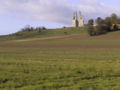
Mont-Saint-Éloi is situated 5 miles (8 km) northwest of Arras, at the junction of the D341 and the D49 roads, on the banks of the river Scarpe.
Population
| Year | Pop. | ±% p.a. |
|---|---|---|
| 1968 | 1,042 | — |
| 1975 | 1,056 | +0.19% |
| 1982 | 1,023 | −0.45% |
| 1990 | 982 | −0.51% |
| 1999 | 1,018 | +0.40% |
| 2007 | 1,009 | −0.11% |
| 2012 | 1,011 | +0.04% |
| 2017 | 1,023 | +0.24% |
| Source: INSEE[4] | ||
Places of interest
- The church of St. Joseph, dating from the sixteenth century.
- The Commonwealth War Graves Commission cemetery.
- The eighteenth-century chateau d’Écoivres.
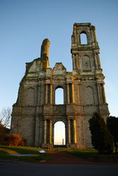
- Remains of an abbey church, destroyed in 1783.
- Two menhirs, known as the Twin Stones.
Mont Saint-Éloi Abbey
The monastery was founded in the 7th century by Vindicianus, bishop of Arras and devotee of Saint Eligius. The bishop was buried in the nearby Bois d'Ecoives, but his relics were subsequently removed to the Abbey Church of St. Joseph, which was enlarged in the 11th century. The abbey adopted the Rule of Saint Augustine, and was the motherhouse of St. Botolph's Priory in Colchester.[5] The medieval buildings were demolished in 1750 to make way for a church and convent, necessitated by the aging and shallow foundations of the old abbey.
During the Revolution, the monks left and the abbey was converted into a quarry and pillaged for the stone.[6] What remained of the towers and facade serving as a military observation point during the First World War. In 1915 heavy shelling damaged the towers. It is a protected monument.[7]
-
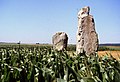 The menhirs
 -
 Menhirs
 -
 Écoivres village
 -
 Features on the church spire
 -
 Aerial view of the countryside
 -
 Aerial view
 -
 Aerial view of the abbey
 -
 Towers of the abbey of Mont Saint-Éloi


See also
References
- ^ "Répertoire national des élus: les maires". data.gouv.fr, Plateforme ouverte des données publiques françaises (in French). 2 December 2020.
- ^ "Populations légales 2021". The National Institute of Statistics and Economic Studies. 28 December 2023.
- ^ INSEE commune file
- ^ Population en historique depuis 1968, INSEE
- ^ "Houses of Austin canons: Priory of St Botolph, Colchester | British History Online".
- ^ "One of the biggest abbeys of the Hauts-de-France", Arras Pays d’Artois Tourisme
- ^ "Ancienne église abbatiale à Mont-Saint-Eloi", Monumentum, Carte des Monuments Historiques français
External links
Wikimedia Commons has media related to Mont-Saint-Éloi.
- The CWGC cemetery at Écoivres
- v
- t
- e
Communes of the Pas-de-Calais department
- Ablain-Saint-Nazaire
- Ablainzevelle
- Acheville
- Achicourt
- Achiet-le-Grand
- Achiet-le-Petit
- Acq
- Acquin-Westbécourt
- Adinfer
- Affringues
- Agnez-lès-Duisans
- Agnières
- Agny
- Aire-sur-la-Lys
- Airon-Notre-Dame
- Airon-Saint-Vaast
- Aix-en-Ergny
- Aix-en-Issart
- Aix-Noulette
- Alembon
- Alette
- Alincthun
- Allouagne
- Alquines
- Ambleteuse
- Ambricourt
- Ambrines
- Ames
- Amettes
- Amplier
- Andres
- Angres
- Annay
- Annequin
- Annezin
- Anvin
- Anzin-Saint-Aubin
- Ardres
- Arleux-en-Gohelle
- Arques
- Arraspref
- Athies
- Les Attaques
- Attin
- Aubigny-en-Artois
- Aubin-Saint-Vaast
- Aubrometz
- Auchel
- Auchy-au-Bois
- Auchy-lès-Hesdin
- Auchy-les-Mines
- Audembert
- Audincthun
- Audinghen
- Audrehem
- Audresselles
- Audruicq
- Aumerval
- Autingues
- Auxi-le-Château
- Averdoingt
- Avesnes
- Avesnes-le-Comte
- Avesnes-lès-Bapaume
- Avion
- Avondance
- Avroult
- Ayette
- Azincourt
- Bailleul-aux-Cornailles
- Bailleul-lès-Pernes
- Bailleulmont
- Bailleul-Sir-Berthoult
- Bailleulval
- Baincthun
- Bainghen
- Bajus
- Balinghem
- Bancourt
- Bapaume
- Baralle
- Barastre
- Barlin
- Barly
- Basseux
- Bavincourt
- Bayenghem-lès-Éperlecques
- Bayenghem-lès-Seninghem
- Bazinghen
- Béalencourt
- Beaudricourt
- Beaufort-Blavincourt
- Beaulencourt
- Beaumerie-Saint-Martin
- Beaumetz-lès-Aire
- Beaumetz-lès-Cambrai
- Beaumetz-lès-Loges
- Beaurains
- Beaurainville
- Beauvoir-Wavans
- Beauvois
- Bécourt
- Béhagnies
- Bellebrune
- Belle-et-Houllefort
- Bellinghem
- Bellonne
- Bénifontaine
- Berck
- Bergueneuse
- Berlencourt-le-Cauroy
- Berles-au-Bois
- Berles-Monchel
- Bermicourt
- Berneville
- Bernieulles
- Bertincourt
- Béthonsart
- Béthunesubpr
- Beugin
- Beugnâtre
- Beugny
- Beussent
- Beutin
- Beuvrequen
- Beuvry
- Bezinghem
- Biache-Saint-Vaast
- Biefvillers-lès-Bapaume
- Bienvillers-au-Bois
- Bihucourt
- Billy-Berclau
- Billy-Montigny
- Bimont
- Blairville
- Blangerval-Blangermont
- Blangy-sur-Ternoise
- Blendecques
- Bléquin
- Blessy
- Blingel
- Boffles
- Boiry-Becquerelle
- Boiry-Notre-Dame
- Boiry-Sainte-Rictrude
- Boiry-Saint-Martin
- Bois-Bernard
- Boisdinghem
- Boisjean
- Boisleux-au-Mont
- Boisleux-Saint-Marc
- Bomy
- Bonnières
- Bonningues-lès-Ardres
- Bonningues-lès-Calais
- Boubers-lès-Hesmond
- Boubers-sur-Canche
- Bouin-Plumoison
- Boulogne-sur-Mersubpr
- Bouquehault
- Bourecq
- Bouret-sur-Canche
- Bourlon
- Bournonville
- Bours
- Boursin
- Bourthes
- Bouvelinghem
- Bouvigny-Boyeffles
- Boyaval
- Boyelles
- Brebières
- Brêmes
- Brévillers
- Bréxent-Énocq
- Brias
- Brimeux
- Bruay-la-Buissière
- Brunembert
- Bucquoy
- Buire-au-Bois
- Buire-le-Sec
- Buissy
- Bullecourt
- Bully-les-Mines
- Buneville
- Burbure
- Bus
- Busnes
- Caffiers
- Cagnicourt
- Calaissubpr
- Calonne-Ricouart
- Calonne-sur-la-Lys
- La Calotterie
- Camblain-Châtelain
- Camblain-l'Abbé
- Cambligneul
- Cambrin
- Camiers
- Campagne-lès-Boulonnais
- Campagne-lès-Guines
- Campagne-lès-Hesdin
- Campagne-lès-Wardrecques
- Campigneulles-les-Grandes
- Campigneulles-les-Petites
- Canettemont
- Canlers
- Capelle-Fermont
- La Capelle-lès-Boulogne
- Capelle-lès-Hesdin
- Carency
- Carly
- Carvin
- La Cauchie
- Cauchy-à-la-Tour
- Caucourt
- Caumont
- Cavron-Saint-Martin
- Chelers
- Chériennes
- Chérisy
- Chocques
- Clairmarais
- Clenleu
- Clerques
- Cléty
- Colembert
- Colline-Beaumont
- La Comté
- Conchil-le-Temple
- Conchy-sur-Canche
- Condette
- Contes
- Conteville-en-Ternois
- Conteville-lès-Boulogne
- Coquelles
- Corbehem
- Cormont
- Couin
- Coullemont
- Coulogne
- Coulomby
- Coupelle-Neuve
- Coupelle-Vieille
- Courcelles-le-Comte
- Courcelles-lès-Lens
- Courrières
- Courset
- La Couture
- Couturelle
- Coyecques
- Crémarest
- Crépy
- Créquy
- Croisette
- Croisilles
- Croix-en-Ternois
- Cucq
- Cuinchy
- Dainville
- Dannes
- Delettes
- Denier
- Dennebrœucq
- Desvres
- Diéval
- Divion
- Dohem
- Douchy-lès-Ayette
- Doudeauville
- Dourges
- Douriez
- Douvrin
- Drocourt
- Drouvin-le-Marais
- Duisans
- Dury
- Echinghen
- Éclimeux
- Écoivres
- Écourt-Saint-Quentin
- Écoust-Saint-Mein
- Ecquedecques
- Ecques
- Écuires
- Écurie
- Éleu-dit-Leauwette
- Elnes
- Embry
- Enquin-lez-Guinegatte
- Enquin-sur-Baillons
- Éperlecques
- Épinoy
- Eps
- Équihen-Plage
- Équirre
- Ergny
- Érin
- Erny-Saint-Julien
- Ervillers
- Escalles
- Escœuilles
- Esquerdes
- Essars
- Estevelles
- Estrée
- Estrée-Blanche
- Estrée-Cauchy
- Estrée-Wamin
- Estréelles
- Étaing
- Étaples
- Éterpigny
- Étrun
- Évin-Malmaison
- Famechon
- Fampoux
- Farbus
- Fauquembergues
- Favreuil
- Febvin-Palfart
- Ferfay
- Ferques
- Festubert
- Feuchy
- Ficheux
- Fiefs
- Fiennes
- Fillièvres
- Fléchin
- Flers
- Fleurbaix
- Fleury
- Floringhem
- Foncquevillers
- Fontaine-lès-Boulans
- Fontaine-lès-Croisilles
- Fontaine-lès-Hermans
- Fontaine-l'Étalon
- Fortel-en-Artois
- Fosseux
- Foufflin-Ricametz
- Fouquereuil
- Fouquières-lès-Béthune
- Fouquières-lès-Lens
- Framecourt
- Frémicourt
- Frencq
- Fresnes-lès-Montauban
- Fresnicourt-le-Dolmen
- Fresnoy
- Fresnoy-en-Gohelle
- Fressin
- Fréthun
- Frévent
- Frévillers
- Frévin-Capelle
- Fruges
- Galametz
- Gauchin-Légal
- Gauchin-Verloingt
- Gaudiempré
- Gavrelle
- Gennes-Ivergny
- Givenchy-en-Gohelle
- Givenchy-le-Noble
- Givenchy-lès-la-Bassée
- Gomiécourt
- Gommecourt
- Gonnehem
- Gosnay
- Gouves
- Gouy-en-Artois
- Gouy-en-Ternois
- Gouy-Saint-André
- Gouy-Servins
- Gouy-sous-Bellonne
- Graincourt-lès-Havrincourt
- Grand-Rullecourt
- Grenay
- Grévillers
- Grigny
- Grincourt-lès-Pas
- Groffliers
- Guarbecque
- Guémappe
- Guemps
- Guigny
- Guinecourt
- Guînes
- Guisy
- Habarcq
- Haillicourt
- Haisnes
- Halinghen
- Hallines
- Halloy
- Ham-en-Artois
- Hamblain-les-Prés
- Hamelincourt
- Hames-Boucres
- Hannescamps
- Haplincourt
- Haravesnes
- Hardinghen
- Harnes
- Haucourt
- Haute-Avesnes
- Hautecloque
- Hauteville
- Haut-Loquin
- Havrincourt
- Hébuterne
- Helfaut
- Hendecourt-lès-Cagnicourt
- Hendecourt-lès-Ransart
- Hénin-Beaumont
- Hénin-sur-Cojeul
- Héninel
- Henneveux
- Hénu
- Herbinghen
- Héricourt
- La Herlière
- Herlincourt
- Herlin-le-Sec
- Herly
- Hermaville
- Hermelinghen
- Hermies
- Hermin
- Hernicourt
- Hersin-Coupigny
- Hervelinghen
- Hesdigneul-lès-Béthune
- Hesdigneul-lès-Boulogne
- Hesdin
- Hesdin-l'Abbé
- Hesmond
- Hestrus
- Heuchin
- Heuringhem
- Hézecques
- Hinges
- Hocquinghen
- Houchin
- Houdain
- Houlle
- Houvin-Houvigneul
- Hubersent
- Huby-Saint-Leu
- Huclier
- Hucqueliers
- Hulluch
- Humbercamps
- Humbert
- Humerœuille
- Humières
- Inchy-en-Artois
- Incourt
- Inxent
- Isbergues
- Isques
- Ivergny
- Izel-lès-Équerchin
- Izel-lès-Hameau
- Journy
- Labeuvrière
- Labourse
- Labroye
- Lacres
- Lagnicourt-Marcel
- Laires
- Lambres
- Landrethun-le-Nord
- Landrethun-lès-Ardres
- Lapugnoy
- Lattre-Saint-Quentin
- Laventie
- Lebiez
- Lebucquière
- Léchelle
- Ledinghem
- Lefaux
- Leforest
- Lenssubpr
- Lépine
- Lespesses
- Lespinoy
- Lestrem
- Leubringhen
- Leulinghem
- Leulinghen-Bernes
- Libercourt
- Licques
- Liencourt
- Lières
- Liettres
- Liévin
- Lignereuil
- Ligny-lès-Aire
- Ligny-Saint-Flochel
- Ligny-sur-Canche
- Ligny-Thilloy
- Lillers
- Linghem
- Linzeux
- Lisbourg
- Locon
- La Loge
- Loison-sous-Lens
- Loison-sur-Créquoise
- Longfossé
- Longuenesse
- Longueville
- Longvilliers
- Loos-en-Gohelle
- Lorgies
- Lottinghen
- Louches
- Lozinghem
- Lugy
- Lumbres
- La Madelaine-sous-Montreuil
- Magnicourt-en-Comte
- Magnicourt-sur-Canche
- Maintenay
- Maisnil
- Maisnil-lès-Ruitz
- Maisoncelle
- Maizières
- Mametz
- Manin
- Maninghem
- Maninghen-Henne
- Marant
- Marck
- Marconne
- Marconnelle
- Marenla
- Maresquel-Ecquemicourt
- Marest
- Maresville
- Marles-les-Mines
- Marles-sur-Canche
- Marœuil
- Marquay
- Marquion
- Marquise
- Martinpuich
- Matringhem
- Mazingarbe
- Mazinghem
- Mencas
- Menneville
- Mentque-Nortbécourt
- Mercatel
- Merck-Saint-Liévin
- Méricourt
- Merlimont
- Metz-en-Couture
- Meurchin
- Mingoval
- Moncheaux-lès-Frévent
- Monchel-sur-Canche
- Monchiet
- Monchy-au-Bois
- Monchy-Breton
- Monchy-Cayeux
- Monchy-le-Preux
- Mondicourt
- Mont-Bernanchon
- Montcavrel
- Montenescourt
- Montigny-en-Gohelle
- Montreuil-sur-Mersubpr
- Mont-Saint-Éloi
- Monts-en-Ternois
- Morchies
- Moringhem
- Morval
- Mory
- Moulle
- Mouriez
- Moyenneville
- Muncq-Nieurlet
- Nabringhen
- Nédon
- Nédonchel
- Nempont-Saint-Firmin
- Nesles
- Neufchâtel-Hardelot
- Neulette
- Neuve-Chapelle
- Neuville-au-Cornet
- Neuville-Bourjonval
- Neuville-Saint-Vaast
- Neuville-sous-Montreuil
- Neuville-Vitasse
- Neuvireuil
- Nielles-lès-Ardres
- Nielles-lès-Bléquin
- Nielles-lès-Calais
- Nœux-lès-Auxi
- Nœux-les-Mines
- Nordausques
- Noreuil
- Norrent-Fontes
- Nortkerque
- Nort-Leulinghem
- Nouvelle-Église
- Noyelles-Godault
- Noyelles-lès-Humières
- Noyelles-lès-Vermelles
- Noyelles-sous-Bellonne
- Noyelles-sous-Lens
- Noyellette
- Noyelle-Vion
- Nuncq-Hautecôte
- Oblinghem
- Œuf-en-Ternois
- Offekerque
- Offin
- Offrethun
- Oignies
- Oisy-le-Verger
- Oppy
- Orville
- Ostreville
- Ourton
- Outreau
- Ouve-Wirquin
- Oye-Plage
- Palluel
- Le Parcq
- Parenty
- Pas-en-Artois
- Pelves
- Penin
- Pernes
- Pernes-lès-Boulogne
- Peuplingues
- Pierremont
- Pihem
- Pihen-lès-Guînes
- Pittefaux
- Planques
- Plouvain
- Polincove
- Pommera
- Pommier
- Le Ponchel
- Pont-à-Vendin
- Le Portel
- Prédefin
- Pressy
- Preures
- Pronville-en-Artois
- Puisieux
- Quéant
- Quelmes
- Quercamps
- Quernes
- Le Quesnoy-en-Artois
- Quesques
- Questrecques
- Quiéry-la-Motte
- Quiestède
- Quilen
- Quœux-Haut-Maînil
- Racquinghem
- Radinghem
- Ramecourt
- Rang-du-Fliers
- Ransart
- Raye-sur-Authie
- Rebergues
- Rebreuve-Ranchicourt
- Rebreuve-sur-Canche
- Rebreuviette
- Reclinghem
- Récourt
- Recques-sur-Course
- Recques-sur-Hem
- Regnauville
- Rely
- Remilly-Wirquin
- Rémy
- Renty
- Rety
- Richebourg
- Riencourt-lès-Bapaume
- Riencourt-lès-Cagnicourt
- Rimboval
- Rinxent
- Rivière
- Robecq
- Roclincourt
- Rocquigny
- Rodelinghem
- Roëllecourt
- Rœux
- Rollancourt
- Rombly
- Roquetoire
- Rougefay
- Roussent
- Rouvroy
- Royon
- Ruisseauville
- Ruitz
- Rumaucourt
- Rumilly
- Ruminghem
- Ruyaulcourt
- Sachin
- Sailly-au-Bois
- Sailly-en-Ostrevent
- Sailly-Labourse
- Sailly-sur-la-Lys
- Sains-en-Gohelle
- Sains-lès-Fressin
- Sains-lès-Marquion
- Sains-lès-Pernes
- Saint-Amand
- Saint-Aubin
- Saint-Augustin
- Saint-Denœux
- Sainte-Austreberthe
- Sainte-Catherine
- Sainte-Marie-Kerque
- Saint-Étienne-au-Mont
- Saint-Floris
- Saint-Folquin
- Saint-Georges
- Saint-Hilaire-Cottes
- Saint-Inglevert
- Saint-Josse
- Saint-Laurent-Blangy
- Saint-Léger
- Saint-Léonard
- Saint-Martin-Boulogne
- Saint-Martin-Choquel
- Saint-Martin-d'Hardinghem
- Saint-Martin-lez-Tatinghem
- Saint-Martin-sur-Cojeul
- Saint-Michel-sous-Bois
- Saint-Michel-sur-Ternoise
- Saint-Nicolas
- Saint-Omersubpr
- Saint-Omer-Capelle
- Saint-Pol-sur-Ternoise
- Saint-Rémy-au-Bois
- Saint-Tricat
- Saint-Venant
- Sallaumines
- Salperwick
- Samer
- Sangatte
- Sanghen
- Sapignies
- Le Sars
- Sars-le-Bois
- Sarton
- Sauchy-Cauchy
- Sauchy-Lestrée
- Saudemont
- Saulchoy
- Saulty
- Savy-Berlette
- Selles
- Sempy
- Seninghem
- Senlecques
- Senlis
- Séricourt
- Serques
- Servins
- Setques
- Sibiville
- Simencourt
- Siracourt
- Sombrin
- Sorrus
- Souastre
- Souchez
- Le Souich
- Surques
- Sus-Saint-Léger
- Tangry
- Tardinghen
- Teneur
- Ternas
- Thélus
- Thérouanne
- Thiembronne
- La Thieuloye
- Thièvres
- Tigny-Noyelle
- Tilloy-lès-Hermaville
- Tilloy-lès-Mofflaines
- Tilly-Capelle
- Tilques
- Tincques
- Tingry
- Tollent
- Torcy
- Tortefontaine
- Tortequesne
- Le Touquet-Paris-Plage
- Tournehem-sur-la-Hem
- Tramecourt
- Le Transloy
- Trescault
- Troisvaux
- Tubersent
- Vacquerie-le-Boucq
- Vacqueriette-Erquières
- Valhuon
- Vaudricourt
- Vaudringhem
- Vaulx
- Vaulx-Vraucourt
- Vélu
- Vendin-lès-Béthune
- Vendin-le-Vieil
- Verchin
- Verchocq
- Verlincthun
- Vermelles
- Verquigneul
- Verquin
- Verton
- Vieil-Hesdin
- Vieille-Chapelle
- Vieille-Église
- Vieil-Moutier
- Villers-au-Bois
- Villers-au-Flos
- Villers-Brûlin
- Villers-Châtel
- Villers-lès-Cagnicourt
- Villers-l'Hôpital
- Villers-Sir-Simon
- Vimy
- Vincly
- Violaines
- Vis-en-Artois
- Vitry-en-Artois
- Waben
- Wacquinghen
- Wail
- Wailly
- Wailly-Beaucamp
- Wambercourt
- Wamin
- Wancourt
- Wanquetin
- Wardrecques
- Warlencourt-Eaucourt
- Warlincourt-lès-Pas
- Warlus
- Warluzel
- Le Wast
- Wavrans-sur-l'Aa
- Wavrans-sur-Ternoise
- Westrehem
- Wicquinghem
- Widehem
- Wierre-au-Bois
- Wierre-Effroy
- Willeman
- Willencourt
- Willerval
- Wimereux
- Wimille
- Wingles
- Wirwignes
- Wismes
- Wisques
- Wissant
- Witternesse
- Wittes
- Wizernes
- Ytres
- Zoteux
- Zouafques
- Zudausques
- Zutkerque
- pref: prefecture
- subpr: subprefecture
Authority control databases | |
|---|---|
| International |
|
| National |
|
| Geographic |
|


