Terherne
Village in Friesland, Netherlands
Terhorne Terherne | |
|---|---|
Village | |
 Terhorne church | |
 Flag  Coat of arms | |
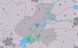 Location in the former Boarnsterhim municipality | |
53°2′25″N 5°46′51″E / 53.04028°N 5.78083°E / 53.04028; 5.78083 | |
| Country |  Netherlands Netherlands |
| Province |  Friesland Friesland |
| Municipality |  De Fryske Marren De Fryske Marren |
| Area | |
| • Total | 9.15 km2 (3.53 sq mi) |
| Elevation | 0.2 m (0.7 ft) |
| Population (2021)[1] | |
| • Total | 760 |
| • Density | 83/km2 (220/sq mi) |
| Postal code | 8493 |
| Dialing code | 0566 |
Terherne (Dutch: Terhorne) is a village in De Fryske Marren in the province of Friesland, the Netherlands. it had a population of around 780 in 2017.[3]
History
The village was first mentioned in 1491 as ter Herna, and means "near the corner".[4] In 1840, it was home to 509 people. The Dutch Reformed Church dates from 1874. Terherne has become a recreational village with many holiday homes, and during the holidays the population can increase to around 6,000 people.[5]
Before 2014, Terherne was part of the Boarnsterhim municipality and before 1984 it was part of Utingeradeel.[5]
Transportation
The nearest station is Akkrum railway station.
Gallery
-
 Canal in Terherne
 -
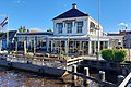 Restaurant De Gouden Liuw
 -
 Bridge at Terherne
 -
 Sunset over the lake


References
- ^ a b "Kerncijfers wijken en buurten 2021". Central Bureau of Statistics. Retrieved 30 March 2022.
- ^ "Postcodetool for 8493KA". Actueel Hoogtebestand Nederland (in Dutch). Het Waterschapshuis. Retrieved 29 March 2022.
- ^ Kerncijfers wijken en buurten 2017 - CBS
- ^ "Terherne - (geografische naam)". Etymologiebank (in Dutch). Retrieved 30 March 2022.
- ^ a b "Terherne". Plaatsengids (in Dutch). Retrieved 30 March 2022.
External links
![]() Media related to Terherne at Wikimedia Commons
Media related to Terherne at Wikimedia Commons
- v
- t
- e
Populated places in the municipality of De Fryske Marren
- Joure
- Lemmer
- Sloten
- Former municipalities: Gaasterlân-Sleat
- Lemsterland
- Skarsterlân
- Akmarijp
- Bakhuizen
- Balk
- Bantega
- Boornzwaag
- Broek
- Delfstrahuizen
- Dijken
- Doniaga
- Echten
- Echtenerbrug
- Eesterga
- Elahuizen
- Follega
- Goingarijp
- Harich
- Haskerhorne
- Idskenhuizen
- Kolderwolde
- Langweer
- Legemeer
- Mirns
- Nijehaske
- Nijemirdum
- Oldeouwer
- Oosterzee
- Oudega
- Oudehaske
- Oudemirdum
- Ouwster-Nijega
- Ouwsterhaule
- Rijs
- Rohel
- Rotstergaast
- Rotsterhaule
- Rottum
- Ruigahuizen
- Scharsterbrug
- Sint Nicolaasga
- Sintjohannesga
- Snikzwaag
- Sondel
- Terherne
- Terkaple
- Teroele
- Tjerkgaast
- Vegelinsoord
- Wijckel
| Authority control databases: National |
|
|---|
 | This Friesland location article is a stub. You can help Wikipedia by expanding it. |
- v
- t
- e


