List of mountain peaks of Utah

This article comprises three sortable tables of major mountain peaks[1] of the U.S. State of Utah.
The summit of a mountain or hill may be measured in three principal ways:
- The topographic elevation of a summit measures the height of the summit above a geodetic sea level.[2][3] The first table below ranks the 50 highest major summits of Utah by elevation.
- The topographic prominence of a summit is a measure of how high the summit rises above its surroundings.[4][3] The second table below ranks the 50 most prominent summits of Utah.
- The topographic isolation (or radius of dominance) of a summit measures how far the summit lies from its nearest point of equal elevation.[5] The third table below ranks the 50 most isolated major summits of Utah.
Highest major summits
Map this section's coordinates using OpenStreetMap
Download coordinates as:
- KML
- GPX (all coordinates)
- GPX (primary coordinates)
- GPX (secondary coordinates)
Of the highest major summits of Utah, Kings Peak exceeds 4000 meters (13,123 feet) elevation, 14 peaks exceed 3500 meters (11,483 feet), and 43 peaks exceed 3000 meters (9843 feet) elevation.
| Rank | Mountain peak | Mountain range | Elevation | Prominence | Isolation | Location |
|---|---|---|---|---|---|---|
| 1 | Kings Peak[6][7][8][a][b] | Uinta Mountains | 13,534 ft 4125 m | 6,358 ft 1938 m | 166.6 mi 268 km | 40°46′35″N 110°22′22″W / 40.7763°N 110.3729°W / 40.7763; -110.3729 (Kings Peak) |
| 2 | Mount Peale[9][10][11][12][c] | La Sal Mountains | 12,726 ft 3879 m | 6,181 ft 1884 m | 72.8 mi 117.1 km | 38°26′19″N 109°13′45″W / 38.4385°N 109.2292°W / 38.4385; -109.2292 (Mount Peale) |
| 3 | Mount Waas[13][14][15][16] | La Sal Mountains | 12,316 ft 3753.8 m | 1,793 ft 547 m | 5.24 mi 8.43 km | 38°32′21″N 109°13′40″W / 38.5391°N 109.2278°W / 38.5391; -109.2278 (Mount Waas) |
| 4 | Delano Peak[17][18][19][20][d] | Tushar Mountains | 12,174 ft 3710.7 m | 4,709 ft 1435 m | 112.1 mi 180.5 km | 38°22′09″N 112°22′17″W / 38.3692°N 112.3714°W / 38.3692; -112.3714 (Delano Peak) |
| 5 | Ibapah Peak[21][22][23][e][f] | Deep Creek Range | 12,092 ft 3686 m | 5,267 ft 1605 m | 61.2 mi 98.5 km | 39°49′42″N 113°55′12″W / 39.8282°N 113.9200°W / 39.8282; -113.9200 (Ibapah Peak) |
| 6 | Bald Mountain[24][25][26][27][g] | Uinta Mountains | 11,948 ft 3642 m | 1,843 ft 562 m | 4.01 mi 6.45 km | 40°41′56″N 110°54′11″W / 40.6989°N 110.9031°W / 40.6989; -110.9031 (Bald Mountain) |
| 7 | Mount Nebo[28][29][30][h][i] | Wasatch Range | 11,933 ft 3637 m | 5,508 ft 1679 m | 75.6 mi 121.6 km | 39°49′19″N 111°45′37″W / 39.8219°N 111.7603°W / 39.8219; -111.7603 (Mount Nebo) |
| 8 | South Mountain[31][32][33][j] | La Sal Mountains | 11,822 ft 3603 m | 1,679 ft 512 m | 2.65 mi 4.26 km | 38°24′04″N 109°15′41″W / 38.4011°N 109.2615°W / 38.4011; -109.2615 (South Mountain) |
| 9 | Mount Timpanogos[34][35][36][37][k] | Wasatch Range | 11,752 ft 3582 m | 5,279 ft 1609 m | 39.6 mi 63.8 km | 40°23′27″N 111°38′45″W / 40.3908°N 111.6459°W / 40.3908; -111.6459 (Mount Timpanogos) |
| 10 | Fish Lake Hightop[38][39][40][l] | Fish Lake Plateau | 11,639 ft 3547.5 m | 4,157 ft 1267 m | 35.5 mi 57.1 km | 38°36′29″N 111°44′22″W / 38.6080°N 111.7394°W / 38.6080; -111.7394 (Fish Lake Hightop) |
| 11 | Mount Marvine[41][42][43][44] | Fish Lake Plateau | 11,604 ft 3537 m | 1,870 ft 570 m | 6.75 mi 10.86 km | 38°40′06″N 111°38′28″W / 38.6682°N 111.6411°W / 38.6682; -111.6411 (Mount Marvine) |
| 12 | Mount Hilgard[45][46][47][m] | Fish Lake Plateau | 11,538 ft 3517 m | 2,103 ft 641 m | 5.37 mi 8.65 km | 38°41′03″N 111°32′38″W / 38.6841°N 111.5438°W / 38.6841; -111.5438 (Mount Hilgard) |
| 13 | Mount Ellen Peak[48][49][50][n][o] | Henry Mountains | 11,527 ft 3513 m | 5,862 ft 1787 m | 56 mi 90.2 km | 38°06′32″N 110°48′49″W / 38.1089°N 110.8136°W / 38.1089; -110.8136 (Mount Ellen Peak) |
| 14 | Twin Peaks[51][52][53][p] | Wasatch Range | 11,494 ft 3503 m | 3,669 ft 1118 m | 11.12 mi 17.89 km | 40°33′06″N 111°39′24″W / 40.5518°N 111.6566°W / 40.5518; -111.6566 (Twin Peaks) |
| 15 | Mount Pennell[54][55][56][57] | Henry Mountains | 11,413 ft 3478.7 m | 3,588 ft 1094 m | 8.02 mi 12.9 km | 37°57′23″N 110°47′27″W / 37.9564°N 110.7908°W / 37.9564; -110.7908 (Mount Pennell) |
| 16 | Abajo Peak[58][59][60][61][q] | Abajo Mountains | 11,362 ft 3463 m | 4,555 ft 1388 m | 39.9 mi 64.2 km | 37°50′22″N 109°27′45″W / 37.8395°N 109.4624°W / 37.8395; -109.4624 (Abajo Peak) |
| 17 | Bluebell Knoll[62][63][64][r] | Aquarius Plateau | 11,346 ft 3458 m | 2,930 ft 893 m | 32.6 mi 52.5 km | 38°09′34″N 111°30′01″W / 38.1594°N 111.5004°W / 38.1594; -111.5004 (Bluebell Knoll) |
| 18 | Circleville Mountain[65][66][67][68] | Tushar Mountains | 11,336 ft 3455.3 m | 1,671 ft 509 m | 11.05 mi 17.79 km | 38°11′47″N 112°24′07″W / 38.1964°N 112.4020°W / 38.1964; -112.4020 (Circleville Mountain) |
| 19 | Brian Head[69][70][71][s][t] | Markagunt Plateau | 11,312 ft 3448 m | 3,767 ft 1148 m | 42.5 mi 68.5 km | 37°40′52″N 112°49′52″W / 37.6812°N 112.8312°W / 37.6812; -112.8312 (Brian Head) |
| 20 | Thousand Lake Mountain[72][73][74][75] | Fish Lake Plateau | 11,300 ft 3444.3 m | 2,366 ft 721 m | 17.81 mi 28.7 km | 38°25′02″N 111°28′45″W / 38.4171°N 111.4793°W / 38.4171; -111.4793 (Thousand Lake Mountain) |
| 21 | South Tent Mountain[76][77][78][79][u] | Wasatch Plateau | 11,288 ft 3440.5 m | 3,385 ft 1032 m | 35.8 mi 57.5 km | 39°23′32″N 111°21′27″W / 39.3922°N 111.3576°W / 39.3922; -111.3576 (South Tent Mountain) |
| 22 | Monroe Peak[80][81][82][83][v] | Sevier Plateau | 11,232 ft 3423.6 m | 4,117 ft 1255 m | 17.17 mi 27.6 km | 38°32′10″N 112°04′24″W / 38.5361°N 112.0734°W / 38.5361; -112.0734 (Monroe Peak) |
| 23 | Glenwood Mountain[84][85][86][87] | Sevier Plateau | 11,220 ft 3420 m | 1,846 ft 563 m | 6.9 mi 11.11 km | 38°37′31″N 112°00′57″W / 38.6253°N 112.0157°W / 38.6253; -112.0157 (Glenwood Mountain) |
| 24 | Provo Peak[88][89][90][w] | Wasatch Range | 11,072 ft 3375 m | 3,448 ft 1051 m | 10.54 mi 16.97 km | 40°14′39″N 111°33′25″W / 40.2443°N 111.5570°W / 40.2443; -111.5570 (Provo Peak) |
| 25 | Mount Dutton[91][92][93][94] | Sevier Plateau | 11,047 ft 3367.2 m | 3,411 ft 1040 m | 15.76 mi 25.4 km | 38°01′14″N 112°13′02″W / 38.0206°N 112.2173°W / 38.0206; -112.2173 (Mount Dutton) |
| 26 | Deseret Peak[95][96][97][x] | Stansbury Mountains | 11,035 ft 3364 m | 5,812 ft 1772 m | 46 mi 74 km | 40°27′34″N 112°37′35″W / 40.4595°N 112.6264°W / 40.4595; -112.6264 (Deseret Peak) |
| 27 | Bald Mountain[98][99][100][101] | Wasatch Range | 10,920 ft 3328.3 m | 1,713 ft 522 m | 2.71 mi 4.36 km | 39°52′38″N 111°45′29″W / 39.8772°N 111.7581°W / 39.8772; -111.7581 (Bald Mountain) |
| 28 | Rocky Peak[102][103][104][y] | Deep Creek Range | 10,753 ft 3277 m | 1,823 ft 556 m | 4.42 mi 7.11 km | 39°54′42″N 113°53′51″W / 39.9116°N 113.8974°W / 39.9116; -113.8974 (Rocky Peak) |
| 29 | Mount Hillers[105][106][107][z] | Henry Mountains | 10,741 ft 3274 m | 3,357 ft 1023 m | 7 mi 11.27 km | 37°53′15″N 110°41′49″W / 37.8874°N 110.6970°W / 37.8874; -110.6970 (Mount Hillers) |
| 30 | Loafer Mountain[108][109][110][111] | Wasatch Range | 10,689 ft 3258 m | 2,905 ft 885 m | 10.22 mi 16.45 km | 39°59′00″N 111°37′25″W / 39.9833°N 111.6237°W / 39.9833; -111.6237 (Loafer Mountain) |
| 31 | Flat Top Mountain[112][113][114][aa][ab] | Oquirrh Mountains | 10,624 ft 3238 m | 5,383 ft 1641 m | 23.8 mi 38.4 km | 40°22′21″N 112°11′20″W / 40.3724°N 112.1888°W / 40.3724; -112.1888 (Flat Top Mountain) |
| 32 | Signal Peak[115][116][117][ac][ad] | Pine Valley Mountains | 10,369 ft 3161 m | 4,505 ft 1373 m | 35 mi 56.3 km | 37°19′10″N 113°29′32″W / 37.3195°N 113.4922°W / 37.3195; -113.4922 (Signal Peak) |
| 33 | Navajo Mountain[118][119][120][121] | Colorado Plateau | 10,348 ft 3154.2 m | 4,236 ft 1291 m | 58.6 mi 94.3 km | 37°02′03″N 110°52′11″W / 37.0343°N 110.8697°W / 37.0343; -110.8697 (Navajo Mountain) |
| 34 | Strawberry Peak[122][123][124][125][ae] | Roan Cliffs | 10,341 ft 3152 m | 2,338 ft 713 m | 19.46 mi 31.3 km | 40°02′49″N 110°59′05″W / 40.0470°N 110.9847°W / 40.0470; -110.9847 (Strawberry Peak) |
| 35 | Mine Camp Peak[126][127][128][af][ag] | Pavant Range | 10,227 ft 3117 m | 3,001 ft 915 m | 20.1 mi 32.3 km | 38°52′25″N 112°15′12″W / 38.8737°N 112.2534°W / 38.8737; -112.2534 (Mine Camp Peak) |
| 36 | Spanish Fork Peak[129][130][131][132] | Wasatch Range | 10,196 ft 3107.6 m | 2,972 ft 906 m | 8.83 mi 14.21 km | 40°05′16″N 111°31′40″W / 40.0879°N 111.5277°W / 40.0879; -111.5277 (Spanish Fork Peak) |
| 37 | Bruin Point[133][134][135] | Roan Cliffs | 10,187 ft 3105 m | 2,724 ft 830 m | 42.9 mi 69.1 km | 39°38′39″N 110°20′54″W / 39.6442°N 110.3482°W / 39.6442; -110.3482 (Bruin Point) |
| 38 | Salt Benchmark[136][137][138][ah] | San Pitch Mountains | 10,001 ft 3048.4 m | 3,697 ft 1127 m | 10.13 mi 16.3 km | 39°39′54″N 111°44′36″W / 39.6649°N 111.7432°W / 39.6649; -111.7432 (Salt Benchmark) |
| 39 | Shay Mountain[139][140][141][ai] | Abajo Mountains | 9,993 ft 3046 m | 1,649 ft 503 m | 6.19 mi 9.96 km | 37°56′08″N 109°32′56″W / 37.9355°N 109.5489°W / 37.9355; -109.5489 (Shay Mountain) |
| 40 | Naomi Peak[142][143][144][145][aj] | Wasatch Range | 9,984 ft 3043 m | 3,169 ft 966 m | 61.5 mi 98.9 km | 41°54′41″N 111°40′31″W / 41.9114°N 111.6754°W / 41.9114; -111.6754 (Naomi Peak) |
| 41 | Bull Mountain[146][ak][al] | Raft River Mountains | 9,938 ft 3029 m | 3,754 ft 1144 m | 24.3 mi 39.2 km | 41°54′36″N 113°21′57″W / 41.9100°N 113.3659°W / 41.9100; -113.3659 (Bull Mountain) |
| 42 | Raft River Peak[147][148] | Raft River Mountains | 9,931 ft 3027 m | 3,740 ft 1140 m | 23.9 mi 38.5 km | 41°54′17″N 113°23′20″W / 41.9048°N 113.3888°W / 41.9048; -113.3888 (Raft River Peak) |
| 43 | Dry Mountain[149][150][151][am] | Wasatch Range | 9,869 ft 3008 m | 1,845 ft 562 m | 4.59 mi 7.39 km | 39°56′26″N 111°43′54″W / 39.9406°N 111.7316°W / 39.9406; -111.7316 (Dry Mountain) |
| 44 | Indian Peak[152][153][154][an][ao] | Indian Peak Range | 9,795 ft 2985 m | 3,660 ft 1116 m | 39.6 mi 63.7 km | 38°16′01″N 113°52′31″W / 38.2670°N 113.8753°W / 38.2670; -113.8753 (Indian Peak) |
| 45 | Willard Peak[155][156][157][158][ap] | Wasatch Range | 9,771 ft 2978.1 m | 3,263 ft 995 m | 39.4 mi 63.5 km | 41°22′58″N 111°58′29″W / 41.3828°N 111.9746°W / 41.3828; -111.9746 (Willard Peak) |
| 46 | Logan Peak[159][160][161][162] | Bear River Mountains | 9,719 ft 2962.2 m | 2,995 ft 913 m | 13.83 mi 22.3 km | 41°42′49″N 111°43′04″W / 41.7135°N 111.7177°W / 41.7135; -111.7177 (Logan Peak) |
| 47 | Fool Creek Peak[163][164][165][166][aq] | Canyon Mountains | 9,717 ft 2961.7 m | 3,732 ft 1138 m | 23.1 mi 37.3 km | 39°23′33″N 112°12′26″W / 39.3926°N 112.2072°W / 39.3926; -112.2072 (Fool Creek Peak) |
| 48 | Thurston Peak[167][168][169][170] | Wasatch Range | 9,710 ft 2959.68 m | 2,697 ft 822 m | 20.2 mi 32.6 km | 41°04′55″N 111°51′06″W / 41.0820°N 111.8516°W / 41.0820; -111.8516 (Thurston Peak) |
| 49 | Swasey Peak[171][172][173][174][ar][as] | House Range | 9,675 ft 2949 m | 4,529 ft 1380 m | 40.7 mi 65.5 km | 39°23′18″N 113°18′59″W / 39.3882°N 113.3164°W / 39.3882; -113.3164 (Swasey Peak) |
| 50 | Frisco Peak[175][176][177][178][at] | San Francisco Mountains | 9,663 ft 2945.25 m | 4,040 ft 1231 m | 36.3 mi 58.4 km | 38°31′13″N 113°17′15″W / 38.5204°N 113.2876°W / 38.5204; -113.2876 (Frisco Peak) |
Most prominent summits
Map this section's coordinates using OpenStreetMap
Download coordinates as:
- KML
- GPX (all coordinates)
- GPX (primary coordinates)
- GPX (secondary coordinates)
Of the most prominent summits of Utah, eight peaks are ultra-prominent summits with more than 1500 meters (4921 feet) of topographic prominence and 33 peaks exceed 1000 meters (3281 feet) of topographic prominence.
| Rank | Mountain peak | Mountain range | Elevation | Prominence | Isolation | Location |
|---|---|---|---|---|---|---|
| 1 | Kings Peak[6][7][8][a][b] | Uinta Mountains | 13,534 ft 4125 m | 6,358 ft 1938 m | 166.6 mi 268 km | 40°46′35″N 110°22′22″W / 40.7763°N 110.3729°W / 40.7763; -110.3729 (Kings Peak) |
| 2 | Mount Peale[9][10][11][12][c] | La Sal Mountains | 12,726 ft 3879 m | 6,181 ft 1884 m | 72.8 mi 117.1 km | 38°26′19″N 109°13′45″W / 38.4385°N 109.2292°W / 38.4385; -109.2292 (Mount Peale) |
| 3 | Mount Ellen Peak[48][49][50][n][o] | Henry Mountains | 11,527 ft 3513 m | 5,862 ft 1787 m | 56 mi 90.2 km | 38°06′32″N 110°48′49″W / 38.1089°N 110.8136°W / 38.1089; -110.8136 (Mount Ellen Peak) |
| 4 | Deseret Peak[95][96][97][x] | Stansbury Mountains | 11,035 ft 3364 m | 5,812 ft 1772 m | 46 mi 74 km | 40°27′34″N 112°37′35″W / 40.4595°N 112.6264°W / 40.4595; -112.6264 (Deseret Peak) |
| 5 | Mount Nebo[28][29][30][h][i] | Wasatch Range | 11,933 ft 3637 m | 5,508 ft 1679 m | 75.6 mi 121.6 km | 39°49′19″N 111°45′37″W / 39.8219°N 111.7603°W / 39.8219; -111.7603 (Mount Nebo) |
| 6 | Flat Top Mountain[112][113][114][aa][ab] | Oquirrh Mountains | 10,624 ft 3238 m | 5,383 ft 1641 m | 23.8 mi 38.4 km | 40°22′21″N 112°11′20″W / 40.3724°N 112.1888°W / 40.3724; -112.1888 (Flat Top Mountain) |
| 7 | Mount Timpanogos[34][35][36][37][k] | Wasatch Range | 11,752 ft 3582 m | 5,279 ft 1609 m | 39.6 mi 63.8 km | 40°23′27″N 111°38′45″W / 40.3908°N 111.6459°W / 40.3908; -111.6459 (Mount Timpanogos) |
| 8 | Ibapah Peak[21][22][23][e][f] | Deep Creek Range | 12,092 ft 3686 m | 5,267 ft 1605 m | 61.2 mi 98.5 km | 39°49′42″N 113°55′12″W / 39.8282°N 113.9200°W / 39.8282; -113.9200 (Ibapah Peak) |
| 9 | Delano Peak[17][18][19][20][d] | Tushar Mountains | 12,174 ft 3710.7 m | 4,709 ft 1435 m | 112.1 mi 180.5 km | 38°22′09″N 112°22′17″W / 38.3692°N 112.3714°W / 38.3692; -112.3714 (Delano Peak) |
| 10 | Abajo Peak[58][59][60][61][q] | Abajo Mountains | 11,362 ft 3463 m | 4,555 ft 1388 m | 39.9 mi 64.2 km | 37°50′22″N 109°27′45″W / 37.8395°N 109.4624°W / 37.8395; -109.4624 (Abajo Peak) |
| 11 | Swasey Peak[171][172][173][174][ar][as] | House Range | 9,675 ft 2949 m | 4,529 ft 1380 m | 40.7 mi 65.5 km | 39°23′18″N 113°18′59″W / 39.3882°N 113.3164°W / 39.3882; -113.3164 (Swasey Peak) |
| 12 | Signal Peak[115][116][117][ac][ad] | Pine Valley Mountains | 10,369 ft 3161 m | 4,505 ft 1373 m | 35 mi 56.3 km | 37°19′10″N 113°29′32″W / 37.3195°N 113.4922°W / 37.3195; -113.4922 (Signal Peak) |
| 13 | Navajo Mountain[118][119][120][121] | Colorado Plateau | 10,348 ft 3154.2 m | 4,236 ft 1291 m | 58.6 mi 94.3 km | 37°02′03″N 110°52′11″W / 37.0343°N 110.8697°W / 37.0343; -110.8697 (Navajo Mountain) |
| 14 | Fish Lake Hightop[38][39][40][l] | Fish Lake Plateau | 11,639 ft 3547.5 m | 4,157 ft 1267 m | 35.5 mi 57.1 km | 38°36′29″N 111°44′22″W / 38.6080°N 111.7394°W / 38.6080; -111.7394 (Fish Lake Hightop) |
| 15 | Monroe Peak[80][81][82][83][v] | Sevier Plateau | 11,232 ft 3423.6 m | 4,117 ft 1255 m | 17.17 mi 27.6 km | 38°32′10″N 112°04′24″W / 38.5361°N 112.0734°W / 38.5361; -112.0734 (Monroe Peak) |
| 16 | Frisco Peak[175][176][177][178][at] | San Francisco Mountains | 9,663 ft 2945.25 m | 4,040 ft 1231 m | 36.3 mi 58.4 km | 38°31′13″N 113°17′15″W / 38.5204°N 113.2876°W / 38.5204; -113.2876 (Frisco Peak) |
| 17 | Mount Ogden[179][180][181][182] | Wasatch Range | 9,570 ft 2917 m | 3,830 ft 1167 m | 8.3 mi 13.35 km | 41°12′00″N 111°52′55″W / 41.1999°N 111.8820°W / 41.1999; -111.8820 (Mount Ogden) |
| 18 | Brian Head[69][70][71][s][t] | Markagunt Plateau | 11,312 ft 3448 m | 3,767 ft 1148 m | 42.5 mi 68.5 km | 37°40′52″N 112°49′52″W / 37.6812°N 112.8312°W / 37.6812; -112.8312 (Brian Head) |
| 19 | Bull Mountain[146][ak][al] | Raft River Mountains | 9,938 ft 3029 m | 3,754 ft 1144 m | 24.3 mi 39.2 km | 41°54′36″N 113°21′57″W / 41.9100°N 113.3659°W / 41.9100; -113.3659 (Bull Mountain) |
| 20 | Raft River Peak[147][148] | Raft River Mountains | 9,931 ft 3027 m | 3,740 ft 1140 m | 23.9 mi 38.5 km | 41°54′17″N 113°23′20″W / 41.9048°N 113.3888°W / 41.9048; -113.3888 (Raft River Peak) |
| 21 | Fool Creek Peak[163][164][165][166][aq] | Canyon Mountains | 9,717 ft 2961.7 m | 3,732 ft 1138 m | 23.1 mi 37.3 km | 39°23′33″N 112°12′26″W / 39.3926°N 112.2072°W / 39.3926; -112.2072 (Fool Creek Peak) |
| 22 | Salt Benchmark[136][137][138][ah] | San Pitch Mountains | 10,001 ft 3048.4 m | 3,697 ft 1127 m | 10.13 mi 16.3 km | 39°39′54″N 111°44′36″W / 39.6649°N 111.7432°W / 39.6649; -111.7432 (Salt Benchmark) |
| 23 | Twin Peaks[51][52][53][p] | Wasatch Range | 11,494 ft 3503 m | 3,669 ft 1118 m | 11.12 mi 17.89 km | 40°33′06″N 111°39′24″W / 40.5518°N 111.6566°W / 40.5518; -111.6566 (Twin Peaks) |
| 24 | Indian Peak[183][184][185][au][av] | Indian Peak Range | 9,795 ft 2985 m | 3,660 ft 1116 m | 39.6 mi 63.7 km | 38°16′01″N 113°52′31″W / 38.2670°N 113.8753°W / 38.2670; -113.8753 (Indian Peak) |
| West Mountain Peak[186][187][188][189][aw] | Beaver Dam Mountains | 7,684 ft 2342 m | 3,660 ft 1116 m | 22.1 mi 35.5 km | 37°09′19″N 113°53′00″W / 37.1552°N 113.8833°W / 37.1552; -113.8833 (West Mountain Peak) | |
| 26 | George H. Hansen Peak[190][191][192][193][ax] | Fish Springs Range | 8,527 ft 2599 m | 3,613 ft 1101 m | 23 mi 37 km | 39°43′31″N 113°26′24″W / 39.7252°N 113.4401°W / 39.7252; -113.4401 (George H. Hansen Peak) |
| 27 | Mount Pennell[54][55][56][57] | Henry Mountains | 11,413 ft 3478.7 m | 3,588 ft 1094 m | 8.02 mi 12.9 km | 37°57′23″N 110°47′27″W / 37.9564°N 110.7908°W / 37.9564; -110.7908 (Mount Pennell) |
| 28 | Box Elder Peak[194][195][196][197][ay] | Wellsvillle Mountains | 9,376 ft 2857.8 m | 3,472 ft 1058 m | 16.27 mi 26.2 km | 41°38′08″N 112°00′52″W / 41.6356°N 112.0145°W / 41.6356; -112.0145 (Box Elder Peak) |
| 29 | Provo Peak[88][89][90][w] | Wasatch Range | 11,072 ft 3375 m | 3,448 ft 1051 m | 10.54 mi 16.97 km | 40°14′39″N 111°33′25″W / 40.2443°N 111.5570°W / 40.2443; -111.5570 (Provo Peak) |
| 30 | Notch Peak[198][199][200][201][az] | House Range | 9,658 ft 2943.9 m | 3,434 ft 1047 m | 17.62 mi 28.4 km | 39°08′36″N 113°24′34″W / 39.1432°N 113.4094°W / 39.1432; -113.4094 (Notch Peak) |
| 31 | Mount Dutton[91][92][93][94] | Sevier Plateau | 11,047 ft 3367.2 m | 3,411 ft 1040 m | 15.76 mi 25.4 km | 38°01′14″N 112°13′02″W / 38.0206°N 112.2173°W / 38.0206; -112.2173 (Mount Dutton) |
| 32 | South Tent Mountain[76][77][78][79][u] | Wasatch Plateau | 11,288 ft 3440.5 m | 3,385 ft 1032 m | 35.8 mi 57.5 km | 39°23′32″N 111°21′27″W / 39.3922°N 111.3576°W / 39.3922; -111.3576 (South Tent Mountain) |
| 33 | Mount Hillers[105][106][107][z] | Henry Mountains | 10,741 ft 3274 m | 3,357 ft 1023 m | 7 mi 11.27 km | 37°53′15″N 110°41′49″W / 37.8874°N 110.6970°W / 37.8874; -110.6970 (Mount Hillers) |
| 34 | Willard Peak[155][156][157][158][ap] | Wasatch Range | 9,771 ft 2978.1 m | 3,263 ft 995 m | 39.4 mi 63.5 km | 41°22′58″N 111°58′29″W / 41.3828°N 111.9746°W / 41.3828; -111.9746 (Willard Peak) |
| 35 | Naomi Peak[142][143][144][145][aj] | Wasatch Range | 9,984 ft 3043 m | 3,169 ft 966 m | 61.5 mi 98.9 km | 41°54′41″N 111°40′31″W / 41.9114°N 111.6754°W / 41.9114; -111.6754 (Naomi Peak) |
| 36 | Wah Wah Mountain[202][203][204][ba] | Wah Wah Mountains | 9,387 ft 2861.14 m | 3,084 ft 940 m | 16.8 mi 27 km | 38°21′37″N 113°35′02″W / 38.3602°N 113.5839°W / 38.3602; -113.5839 (Wah Wah Mountain) |
| 37 | Granite Peak[205][206][207][208][bb][bc] | Mineral Mountains | 9,587 ft 2922 m | 3,002 ft 915 m | 20.8 mi 33.4 km | 38°22′58″N 112°48′53″W / 38.3829°N 112.8147°W / 38.3829; -112.8147 (Granite Peak) |
| 38 | Mine Camp Peak[126][127][128][af][ag] | Pavant Range | 10,227 ft 3117 m | 3,001 ft 915 m | 20.1 mi 32.3 km | 38°52′25″N 112°15′12″W / 38.8737°N 112.2534°W / 38.8737; -112.2534 (Mine Camp Peak) |
| 39 | Logan Peak[159][160][161][162] | Bear River Mountains | 9,719 ft 2962.2 m | 2,995 ft 913 m | 13.83 mi 22.3 km | 41°42′49″N 111°43′04″W / 41.7135°N 111.7177°W / 41.7135; -111.7177 (Logan Peak) |
| 40 | Spanish Fork Peak[129][130][131][132] | Wasatch Range | 10,196 ft 3107.6 m | 2,972 ft 906 m | 8.83 mi 14.21 km | 40°05′16″N 111°31′40″W / 40.0879°N 111.5277°W / 40.0879; -111.5277 (Spanish Fork Peak) |
| 41 | Bluebell Knoll[62][63][64][r] | Aquarius Plateau | 11,346 ft 3458 m | 2,930 ft 893 m | 32.6 mi 52.5 km | 38°09′34″N 111°30′01″W / 38.1594°N 111.5004°W / 38.1594; -111.5004 (Bluebell Knoll) |
| 42 | Loafer Mountain[108][109][110][111] | Wasatch Range | 10,689 ft 3258 m | 2,905 ft 885 m | 10.22 mi 16.45 km | 39°59′00″N 111°37′25″W / 39.9833°N 111.6237°W / 39.9833; -111.6237 (Loafer Mountain) |
| 43 | Bruin Point[133][134][135] | Roan Cliffs | 10,187 ft 3105 m | 2,724 ft 830 m | 42.9 mi 69.1 km | 39°38′39″N 110°20′54″W / 39.6442°N 110.3482°W / 39.6442; -110.3482 (Bruin Point) |
| 44 | Thurston Peak[167][168][169][170] | Wasatch Range | 9,710 ft 2959.68 m | 2,697 ft 822 m | 20.2 mi 32.6 km | 41°04′55″N 111°51′06″W / 41.0820°N 111.8516°W / 41.0820; -111.8516 (Thurston Peak) |
| 45 | Thousand Lake Mountain[72][73][74][75] | Fish Lake Plateau | 11,300 ft 3444.3 m | 2,366 ft 721 m | 17.81 mi 28.7 km | 38°25′02″N 111°28′45″W / 38.4171°N 111.4793°W / 38.4171; -111.4793 (Thousand Lake Mountain) |
| 46 | Strawberry Peak[122][123][124][125][ae] | Roan Cliffs | 10,341 ft 3152 m | 2,338 ft 713 m | 19.46 mi 31.3 km | 40°02′49″N 110°59′05″W / 40.0470°N 110.9847°W / 40.0470; -110.9847 (Strawberry Peak) |
| 47 | Mount Hilgard[45][46][47][m] | Fish Lake Plateau | 11,538 ft 3517 m | 2,103 ft 641 m | 5.37 mi 8.65 km | 38°41′03″N 111°32′38″W / 38.6841°N 111.5438°W / 38.6841; -111.5438 (Mount Hilgard) |
| 48 | Mount Marvine[41][42][43][44] | Fish Lake Plateau | 11,604 ft 3537 m | 1,870 ft 570 m | 6.75 mi 10.86 km | 38°40′06″N 111°38′28″W / 38.6682°N 111.6411°W / 38.6682; -111.6411 (Mount Marvine) |
| 49 | Glenwood Mountain[84][85][86][87] | Sevier Plateau | 11,220 ft 3420 m | 1,846 ft 563 m | 6.9 mi 11.11 km | 38°37′31″N 112°00′57″W / 38.6253°N 112.0157°W / 38.6253; -112.0157 (Glenwood Mountain) |
| 50 | Dry Mountain[149][150][151][am] | Wasatch Range | 9,869 ft 3008 m | 1,845 ft 562 m | 4.59 mi 7.39 km | 39°56′26″N 111°43′54″W / 39.9406°N 111.7316°W / 39.9406; -111.7316 (Dry Mountain) |
Most isolated major summits
Map this section's coordinates using OpenStreetMap
Download coordinates as:
- KML
- GPX (all coordinates)
- GPX (primary coordinates)
- GPX (secondary coordinates)
Of the most isolated major summits of Utah, Kings Peak exceeds 200 kilometers (124.3 miles) of topographic isolation and four peaks exceed 100 kilometers (62.14 miles) of topographic isolation.
| Rank | Mountain peak | Mountain range | Elevation | Prominence | Isolation | Location |
|---|---|---|---|---|---|---|
| 1 | Kings Peak[6][7][8][a][b] | Uinta Mountains | 13,534 ft 4125 m | 6,358 ft 1938 m | 166.6 mi 268 km | 40°46′35″N 110°22′22″W / 40.7763°N 110.3729°W / 40.7763; -110.3729 (Kings Peak) |
| 2 | Delano Peak[17][18][19][20][d] | Tushar Mountains | 12,174 ft 3710.7 m | 4,709 ft 1435 m | 112.1 mi 180.5 km | 38°22′09″N 112°22′17″W / 38.3692°N 112.3714°W / 38.3692; -112.3714 (Delano Peak) |
| 3 | Mount Nebo[28][29][30][h][i] | Wasatch Range | 11,933 ft 3637 m | 5,508 ft 1679 m | 75.6 mi 121.6 km | 39°49′19″N 111°45′37″W / 39.8219°N 111.7603°W / 39.8219; -111.7603 (Mount Nebo) |
| 4 | Mount Peale[9][10][11][12][c] | La Sal Mountains | 12,726 ft 3879 m | 6,181 ft 1884 m | 72.8 mi 117.1 km | 38°26′19″N 109°13′45″W / 38.4385°N 109.2292°W / 38.4385; -109.2292 (Mount Peale) |
| 5 | Naomi Peak[142][143][144][145][aj] | Wasatch Range | 9,984 ft 3043 m | 3,169 ft 966 m | 61.5 mi 98.9 km | 41°54′41″N 111°40′31″W / 41.9114°N 111.6754°W / 41.9114; -111.6754 (Naomi Peak) |
| 6 | Ibapah Peak[21][22][23][e][f] | Deep Creek Range | 12,092 ft 3686 m | 5,267 ft 1605 m | 61.2 mi 98.5 km | 39°49′42″N 113°55′12″W / 39.8282°N 113.9200°W / 39.8282; -113.9200 (Ibapah Peak) |
| 7 | Navajo Mountain[118][119][120][121] | Colorado Plateau | 10,348 ft 3154.2 m | 4,236 ft 1291 m | 58.6 mi 94.3 km | 37°02′03″N 110°52′11″W / 37.0343°N 110.8697°W / 37.0343; -110.8697 (Navajo Mountain) |
| 8 | Mount Ellen Peak[48][49][50][n][o] | Henry Mountains | 11,527 ft 3513 m | 5,862 ft 1787 m | 56 mi 90.2 km | 38°06′32″N 110°48′49″W / 38.1089°N 110.8136°W / 38.1089; -110.8136 (Mount Ellen Peak) |
| 9 | Deseret Peak[95][96][97][x] | Stansbury Mountains | 11,035 ft 3364 m | 5,812 ft 1772 m | 46 mi 74 km | 40°27′34″N 112°37′35″W / 40.4595°N 112.6264°W / 40.4595; -112.6264 (Deseret Peak) |
| 10 | Bruin Point[133][134][135] | Roan Cliffs | 10,187 ft 3105 m | 2,724 ft 830 m | 42.9 mi 69.1 km | 39°38′39″N 110°20′54″W / 39.6442°N 110.3482°W / 39.6442; -110.3482 (Bruin Point) |
| 11 | Brian Head[69][70][71][s][t] | Markagunt Plateau | 11,312 ft 3448 m | 3,767 ft 1148 m | 42.5 mi 68.5 km | 37°40′52″N 112°49′52″W / 37.6812°N 112.8312°W / 37.6812; -112.8312 (Brian Head) |
| 12 | Swasey Peak[171][172][173][174][ar][as] | House Range | 9,675 ft 2949 m | 4,529 ft 1380 m | 40.7 mi 65.5 km | 39°23′18″N 113°18′59″W / 39.3882°N 113.3164°W / 39.3882; -113.3164 (Swasey Peak) |
| 13 | Abajo Peak[58][59][60][61][q] | Abajo Mountains | 11,362 ft 3463 m | 4,555 ft 1388 m | 39.9 mi 64.2 km | 37°50′22″N 109°27′45″W / 37.8395°N 109.4624°W / 37.8395; -109.4624 (Abajo Peak) |
| 14 | Mount Timpanogos[34][35][36][37][k] | Wasatch Range | 11,752 ft 3582 m | 5,279 ft 1609 m | 39.6 mi 63.8 km | 40°23′27″N 111°38′45″W / 40.3908°N 111.6459°W / 40.3908; -111.6459 (Mount Timpanogos) |
| 15 | Indian Peak[152][153][154][an][ao] | Indian Peak Range | 9,795 ft 2985 m | 3,660 ft 1116 m | 39.6 mi 63.7 km | 38°16′01″N 113°52′31″W / 38.2670°N 113.8753°W / 38.2670; -113.8753 (Indian Peak) |
| 16 | Willard Peak[155][156][157][158][ap] | Wasatch Range | 9,771 ft 2978.1 m | 3,263 ft 995 m | 39.4 mi 63.5 km | 41°22′58″N 111°58′29″W / 41.3828°N 111.9746°W / 41.3828; -111.9746 (Willard Peak) |
| 17 | Frisco Peak[175][176][177][178][at] | San Francisco Mountains | 9,663 ft 2945.25 m | 4,040 ft 1231 m | 36.3 mi 58.4 km | 38°31′13″N 113°17′15″W / 38.5204°N 113.2876°W / 38.5204; -113.2876 (Frisco Peak) |
| 18 | South Tent Mountain[76][77][78][79][u] | Wasatch Plateau | 11,288 ft 3440.5 m | 3,385 ft 1032 m | 35.8 mi 57.5 km | 39°23′32″N 111°21′27″W / 39.3922°N 111.3576°W / 39.3922; -111.3576 (South Tent Mountain) |
| 19 | Fish Lake Hightop[38][39][40][l] | Fish Lake Plateau | 11,639 ft 3547.5 m | 4,157 ft 1267 m | 35.5 mi 57.1 km | 38°36′29″N 111°44′22″W / 38.6080°N 111.7394°W / 38.6080; -111.7394 (Fish Lake Hightop) |
| 20 | Signal Peak[115][116][117][ac][ad] | Pine Valley Mountains | 10,369 ft 3161 m | 4,505 ft 1373 m | 35 mi 56.3 km | 37°19′10″N 113°29′32″W / 37.3195°N 113.4922°W / 37.3195; -113.4922 (Signal Peak) |
| 21 | Bluebell Knoll[62][63][64][r] | Aquarius Plateau | 11,346 ft 3458 m | 2,930 ft 893 m | 32.6 mi 52.5 km | 38°09′34″N 111°30′01″W / 38.1594°N 111.5004°W / 38.1594; -111.5004 (Bluebell Knoll) |
| 22 | Bull Mountain[146][ak][al] | Raft River Mountains | 9,938 ft 3029 m | 3,754 ft 1144 m | 24.3 mi 39.2 km | 41°54′36″N 113°21′57″W / 41.9100°N 113.3659°W / 41.9100; -113.3659 (Bull Mountain) |
| 23 | Raft River Peak[147][148] | Raft River Mountains | 9,931 ft 3027 m | 3,740 ft 1140 m | 23.9 mi 38.5 km | 41°54′17″N 113°23′20″W / 41.9048°N 113.3888°W / 41.9048; -113.3888 (Raft River Peak) |
| 24 | Flat Top Mountain[112][113][114][aa][ab] | Oquirrh Mountains | 10,624 ft 3238 m | 5,383 ft 1641 m | 23.8 mi 38.4 km | 40°22′21″N 112°11′20″W / 40.3724°N 112.1888°W / 40.3724; -112.1888 (Flat Top Mountain) |
| 25 | Fool Creek Peak[163][164][165][166][aq] | Canyon Mountains | 9,717 ft 2961.7 m | 3,732 ft 1138 m | 23.1 mi 37.3 km | 39°23′33″N 112°12′26″W / 39.3926°N 112.2072°W / 39.3926; -112.2072 (Fool Creek Peak) |
| 26 | George H. Hansen Peak[190][191][192][193][ax] | Fish Springs Range | 8,527 ft 2599 m | 3,613 ft 1101 m | 23 mi 37 km | 39°43′31″N 113°26′24″W / 39.7252°N 113.4401°W / 39.7252; -113.4401 (George H. Hansen Peak) |
| 27 | West Mountain Peak[186][187][188][189][aw] | Beaver Dam Mountains | 7,684 ft 2342 m | 3,660 ft 1116 m | 22.1 mi 35.5 km | 37°09′19″N 113°53′00″W / 37.1552°N 113.8833°W / 37.1552; -113.8833 (West Mountain Peak) |
| 28 | Granite Peak[205][206][207][208][bb][bc] | Mineral Mountains | 9,587 ft 2922 m | 3,002 ft 915 m | 20.8 mi 33.4 km | 38°22′58″N 112°48′53″W / 38.3829°N 112.8147°W / 38.3829; -112.8147 (Granite Peak) |
| 29 | Thurston Peak[167][168][169][170] | Wasatch Range | 9,710 ft 2959.68 m | 2,697 ft 822 m | 20.2 mi 32.6 km | 41°04′55″N 111°51′06″W / 41.0820°N 111.8516°W / 41.0820; -111.8516 (Thurston Peak) |
| 30 | Mine Camp Peak[126][127][128][af][ag] | Pavant Range | 10,227 ft 3117 m | 3,001 ft 915 m | 20.1 mi 32.3 km | 38°52′25″N 112°15′12″W / 38.8737°N 112.2534°W / 38.8737; -112.2534 (Mine Camp Peak) |
| 31 | Strawberry Peak[122][123][124][125][ae] | Roan Cliffs | 10,341 ft 3152 m | 2,338 ft 713 m | 19.46 mi 31.3 km | 40°02′49″N 110°59′05″W / 40.0470°N 110.9847°W / 40.0470; -110.9847 (Strawberry Peak) |
| 32 | Thousand Lake Mountain[72][73][74][75] | Fish Lake Plateau | 11,300 ft 3444.3 m | 2,366 ft 721 m | 17.81 mi 28.7 km | 38°25′02″N 111°28′45″W / 38.4171°N 111.4793°W / 38.4171; -111.4793 (Thousand Lake Mountain) |
| 33 | Notch Peak[198][199][200][201][az] | House Range | 9,658 ft 2943.9 m | 3,434 ft 1047 m | 17.62 mi 28.4 km | 39°08′36″N 113°24′34″W / 39.1432°N 113.4094°W / 39.1432; -113.4094 (Notch Peak) |
| 34 | Monroe Peak[80][81][82][83][v] | Sevier Plateau | 11,232 ft 3423.6 m | 4,117 ft 1255 m | 17.17 mi 27.6 km | 38°32′10″N 112°04′24″W / 38.5361°N 112.0734°W / 38.5361; -112.0734 (Monroe Peak) |
| 35 | Wah Wah Mountain[202][203][204][ba] | Wah Wah Mountains | 9,387 ft 2861.14 m | 3,084 ft 940 m | 16.8 mi 27 km | 38°21′37″N 113°35′02″W / 38.3602°N 113.5839°W / 38.3602; -113.5839 (Wah Wah Mountain) |
| 36 | Box Elder Peak[194][195][196][197][ay] | Wellsvillle Mountains | 9,376 ft 2857.8 m | 3,472 ft 1058 m | 16.27 mi 26.2 km | 41°38′08″N 112°00′52″W / 41.6356°N 112.0145°W / 41.6356; -112.0145 (Box Elder Peak) |
| 37 | Mount Dutton[91][92][93][94] | Sevier Plateau | 11,047 ft 3367.2 m | 3,411 ft 1040 m | 15.76 mi 25.4 km | 38°01′14″N 112°13′02″W / 38.0206°N 112.2173°W / 38.0206; -112.2173 (Mount Dutton) |
| 38 | Logan Peak[159][160][161][162] | Bear River Mountains | 9,719 ft 2962.2 m | 2,995 ft 913 m | 13.83 mi 22.3 km | 41°42′49″N 111°43′04″W / 41.7135°N 111.7177°W / 41.7135; -111.7177 (Logan Peak) |
| 39 | Twin Peaks[51][52][53][p] | Wasatch Range | 11,494 ft 3503 m | 3,669 ft 1118 m | 11.12 mi 17.89 km | 40°33′06″N 111°39′24″W / 40.5518°N 111.6566°W / 40.5518; -111.6566 (Twin Peaks) |
| 40 | Circleville Mountain[65][66][67][68] | Tushar Mountains | 11,336 ft 3455.3 m | 1,671 ft 509 m | 11.05 mi 17.79 km | 38°11′47″N 112°24′07″W / 38.1964°N 112.4020°W / 38.1964; -112.4020 (Circleville Mountain) |
| 41 | Provo Peak[88][89][90][w] | Wasatch Range | 11,072 ft 3375 m | 3,448 ft 1051 m | 10.54 mi 16.97 km | 40°14′39″N 111°33′25″W / 40.2443°N 111.5570°W / 40.2443; -111.5570 (Provo Peak) |
| 42 | Loafer Mountain[108][109][110][111] | Wasatch Range | 10,689 ft 3258 m | 2,905 ft 885 m | 10.22 mi 16.45 km | 39°59′00″N 111°37′25″W / 39.9833°N 111.6237°W / 39.9833; -111.6237 (Loafer Mountain) |
| 43 | Salt Benchmark[136][137][138][ah] | San Pitch Mountains | 10,001 ft 3048.4 m | 3,697 ft 1127 m | 10.13 mi 16.3 km | 39°39′54″N 111°44′36″W / 39.6649°N 111.7432°W / 39.6649; -111.7432 (Salt Benchmark) |
| 44 | Spanish Fork Peak[129][130][131][132] | Wasatch Range | 10,196 ft 3107.6 m | 2,972 ft 906 m | 8.83 mi 14.21 km | 40°05′16″N 111°31′40″W / 40.0879°N 111.5277°W / 40.0879; -111.5277 (Spanish Fork Peak) |
| 45 | Mount Ogden[179][180][181][182] | Wasatch Range | 9,570 ft 2917 m | 3,830 ft 1167 m | 8.3 mi 13.35 km | 41°12′00″N 111°52′55″W / 41.1999°N 111.8820°W / 41.1999; -111.8820 (Mount Ogden) |
| 46 | Mount Pennell[54][55][56][57] | Henry Mountains | 11,413 ft 3478.7 m | 3,588 ft 1094 m | 8.02 mi 12.9 km | 37°57′23″N 110°47′27″W / 37.9564°N 110.7908°W / 37.9564; -110.7908 (Mount Pennell) |
| 47 | Mount Hillers[105][106][107][z] | Henry Mountains | 10,741 ft 3274 m | 3,357 ft 1023 m | 7 mi 11.27 km | 37°53′15″N 110°41′49″W / 37.8874°N 110.6970°W / 37.8874; -110.6970 (Mount Hillers) |
| 48 | Glenwood Mountain[84][85][86][87] | Sevier Plateau | 11,220 ft 3420 m | 1,846 ft 563 m | 6.9 mi 11.11 km | 38°37′31″N 112°00′57″W / 38.6253°N 112.0157°W / 38.6253; -112.0157 (Glenwood Mountain) |
| 49 | Mount Marvine[41][42][43][44] | Fish Lake Plateau | 11,604 ft 3537 m | 1,870 ft 570 m | 6.75 mi 10.86 km | 38°40′06″N 111°38′28″W / 38.6682°N 111.6411°W / 38.6682; -111.6411 (Mount Marvine) |
| 50 | Shay Mountain[139][140][141][ai] | Abajo Mountains | 9,993 ft 3046 m | 1,649 ft 503 m | 6.19 mi 9.96 km | 37°56′08″N 109°32′56″W / 37.9355°N 109.5489°W / 37.9355; -109.5489 (Shay Mountain) |
Gallery
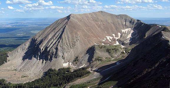
-
 Kings Peak
 -
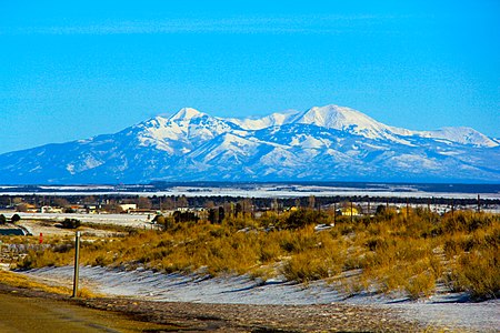
-
 Bald Mountain
 -
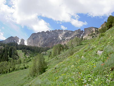
 Mount Nebo is the highest summit of the Wasatch Range.
 -

-
-
 Brian Head
 -


See also
 Geography portal
 North America portal
 United States portal
 Utah portal
 Mountains portal


- List of mountain peaks of North America
- List of mountain peaks of Greenland
- List of mountain peaks of Canada
- List of mountain peaks of the Rocky Mountains
- List of mountain peaks of the United States
- List of mountain peaks of Alaska
- List of mountain peaks of Arizona
- List of mountain peaks of California
- List of mountain peaks of Colorado
- List of mountain peaks of Hawaiʻi
- List of mountain peaks of Idaho
- List of mountain peaks of Montana
- List of mountain peaks of Nevada
- List of mountain peaks of New Mexico
- List of mountain peaks of Oregon
- List of mountain peaks of Utah
- List of mountain peaks of Washington (state)
- List of mountain peaks of Wyoming
- List of mountain peaks of México
- List of mountain peaks of Central America
- List of mountain peaks of the Caribbean
- Utah
- Geography of Utah
- Category:Mountains of Utah
- commons:Category:Mountains of Utah
- Category:Mountains of Utah
- Geography of Utah
- Physical geography
Notes
- ^ a b c The summit of Kings Peak is the highest point of the Uinta Mountains, the U.S. State of Utah, and the western Rocky Mountains.
- ^ a b c The elevation of Kings Peak includes an adjustment of +1.807 m (5.93 ft) from NGVD 29 to NAVD 88.
- ^ a b c The summit of Mount Peale is the highest point of the La Sal Mountains and the Colorado Plateau.
- ^ a b c The summit of Delano Peak is the highest point of the Tushar Mountains.
- ^ a b c The summit of Ibapah Peak is the highest point of the Deep Creek Range.
- ^ a b c The elevation of Ibapah Peak includes an adjustment of +1.517 m (4.98 ft) from NGVD 29 to NAVD 88.
- ^ The elevation of Bald Mountain includes an adjustment of +1.59 m (5.22 ft) from NGVD 29 to NAVD 88.
- ^ a b c The summit of Mount Nebo is the highest point of the Wasatch Range.
- ^ a b c The elevation of Mount Nebo includes an adjustment of +1.395 m (4.58 ft) from NGVD 29 to NAVD 88.
- ^ The elevation of South Mountain includes an adjustment of +1.437 m (4.71 ft) from NGVD 29 to NAVD 88.
- ^ a b c The summit of Mount Timpanogos is the highest point of the central Wasatch Range.
- ^ a b c The summit of Fish Lake Hightop is the highest point of the Fish Lake Plateau.
- ^ a b The elevation of Mount Hilgard includes an adjustment of +1.615 m (5.3 ft) from NGVD 29 to NAVD 88.
- ^ a b c The summit of Mount Ellen Peak is the highest point of the Henry Mountains.
- ^ a b c The elevation of Mount Ellen Peak includes an adjustment of +1.486 m (4.88 ft) from NGVD 29 to NAVD 88.
- ^ a b c The elevation of Twin Peaks includes an adjustment of +1.463 m (4.8 ft) from NGVD 29 to NAVD 88.
- ^ a b c The summit of Abajo Peak is the highest point of the Abajo Mountains.
- ^ a b c The elevation of Bluebell Knoll includes an adjustment of +1.708 m (5.6 ft) from NGVD 29 to NAVD 88.
- ^ a b c The summit of Brian Head is the highest point of the Markagunt Plateau.
- ^ a b c The elevation of Brian Head includes an adjustment of +1.556 m (5.1 ft) from NGVD 29 to NAVD 88.
- ^ a b c The summit of South Tent Mountain is the highest point of the Wasatch Plateau.
- ^ a b c The summit of Monroe Peak is the highest point of the Sevier Plateau.
- ^ a b c The elevation of Provo Peak includes an adjustment of +1.31 m (4.3 ft) from NGVD 29 to NAVD 88.
- ^ a b c The summit of Deseret Peak is the highest point of the Stansbury Mountains.
- ^ The elevation of Rocky Peak includes an adjustment of +1.423 m (4.67 ft) from NGVD 29 to NAVD 88.
- ^ a b c The elevation of Mount Hillers includes an adjustment of +1.364 m (4.48 ft) from NGVD 29 to NAVD 88.
- ^ a b c The summit of Flat Top Mountain is the highest point of the Oquirrh Mountains.
- ^ a b c The elevation of Flat Top Mountain includes an adjustment of +1.329 m (4.36 ft) from NGVD 29 to NAVD 88.
- ^ a b c The summit of Signal Peak is the highest point of the Pine Valley Mountains.
- ^ a b c The elevation of Signal Peak includes an adjustment of +1.249 m (4.1 ft) from NGVD 29 to NAVD 88.
- ^ a b c The summit of Strawberry Peak is the highest point of the Roan Cliffs.
- ^ a b c The summit of Mine Camp Peak is the highest point of the Pavant Range.
- ^ a b c The elevation of Mine Camp Peak includes an adjustment of +1.418 m (4.65 ft) from NGVD 29 to NAVD 88.
- ^ a b c The summit of Salt Benchmark is the highest point of the San Pitch Mountains.
- ^ a b The elevation of Shay Mountain includes an adjustment of +1.249 m (4.1 ft) from NGVD 29 to NAVD 88.
- ^ a b c The summit of Naomi Peak is the highest point of the Bear River Mountains.
- ^ a b c The summit of Bull Mountain is the highest point of the Raft River Mountains.
- ^ a b c The elevation of Bull Mountain includes an adjustment of +1.343 m (4.41 ft) from NGVD 29 to NAVD 88.
- ^ a b The elevation of Dry Mountain includes an adjustment of +1.222 m (4.01 ft) from NGVD 29 to NAVD 88.
- ^ a b The summit of Indian Peak is the highest point of the Indian Peak Range.
- ^ a b The elevation of Indian Peak includes an adjustment of +1.374 m (4.51 ft) from NGVD 29 to NAVD 88.
- ^ a b c The summit of Willard Peak is the highest point of the northern Wasatch Range.
- ^ a b c The summit of Fool Creek Peak is the highest point of the Canyon Mountains.
- ^ a b c The summit of Swasey Peak is the highest point of the House Range.
- ^ a b c The summit elevation of Swasey Peak includes a vertical offset of +0.61 m (2 ft) from the station benchmark.
- ^ a b c The summit of Frisco Peak is the highest point of the San Francisco Mountains.
- ^ The summit of Indian Peak is the highest point of the Indian Peak Range.
- ^ The elevation of Indian Peak includes an adjustment of +1.374 m (4.51 ft) from NGVD 29 to NAVD 88.
- ^ a b The summit of West Mountain Peak is the highest point of the Beaver Dam Mountains.
- ^ a b The summit of George H. Hansen Peak is the highest point of the Fish Springs Range.
- ^ a b The summit of Box Elder Peak is the highest point of the Wellsvillle Mountains.
- ^ a b The summit elevation of Notch Peak includes a vertical offset of +0.102 m (0.3 ft) from the station benchmark.
- ^ a b The summit of Wah Wah Mountain is the highest point of the Wah Wah Mountains.
- ^ a b The summit of Granite Peak is the highest point of the Mineral Mountains.
- ^ a b The summit elevation of Granite Peak includes a vertical offset of +0.61 m (2 ft) from the station benchmark.
References
- ^ This article defines a significant summit as a summit with at least 100 meters (328.1 feet) of topographic prominence, and a major summit as a summit with at least 500 meters (1640 feet) of topographic prominence. All summits in this article have at least 500 meters of topographic prominence. An ultra-prominent summit is a summit with at least 1500 meters (4921 feet) of topographic prominence.
- ^ All elevations in this article include an elevation adjustment from the National Geodetic Vertical Datum of 1929 (NGVD 29) to the North American Vertical Datum of 1988 (NAVD 88). For further information, please see this United States National Geodetic Survey note.
- ^ a b If the elevation or prominence of a summit is calculated as a range of values, the arithmetic mean is shown.
- ^ The topographic prominence of a summit is the topographic elevation difference between the summit and its highest or key col to a higher summit. The summit may be near its key col or quite far away. The key col for Denali in Alaska is the Isthmus of Rivas in Nicaragua, 7642 kilometers (4749 miles) away.
- ^ The topographic isolation of a summit is the great-circle distance to its nearest point of equal elevation.
- ^ a b c "Kings Peak". Geographic Names Information System. United States Geological Survey, United States Department of the Interior.
- ^ a b c "Kings Peak". Peakbagger.com. Retrieved 14 June 2016.
- ^ a b c "Kings Peak". Bivouac.com. Retrieved 14 June 2016.
- ^ a b c "MOUNT PEALE". Datasheet for NGS Station JM0496. U.S. National Geodetic Survey. Retrieved 14 June 2016.
- ^ a b c "Mount Peale". Geographic Names Information System. United States Geological Survey, United States Department of the Interior.
- ^ a b c "Mount Peale". Peakbagger.com. Retrieved 14 June 2016.
- ^ a b c "Mount Peale". Bivouac.com. Retrieved 14 June 2016.
- ^ "MOUNT WAAS RESET". Datasheet for NGS Station JM0478. U.S. National Geodetic Survey. Retrieved 14 June 2016.
- ^ "Mount Waas". Geographic Names Information System. United States Geological Survey, United States Department of the Interior.
- ^ "Mount Waas". Peakbagger.com. Retrieved 14 June 2016.
- ^ "Mount Waas". Bivouac.com. Retrieved 14 June 2016.
- ^ a b c "DELANO PEAK M 5". Datasheet for NGS Station JO0502. U.S. National Geodetic Survey. Retrieved 14 June 2016.
- ^ a b c "Delano Peak". Geographic Names Information System. United States Geological Survey, United States Department of the Interior.
- ^ a b c "Delano Peak". Peakbagger.com. Retrieved 14 June 2016.
- ^ a b c "Delano Peak". Bivouac.com. Retrieved 14 June 2016.
- ^ a b c "Ibapah Peak". Geographic Names Information System. United States Geological Survey, United States Department of the Interior.
- ^ a b c "Ibapah Peak". Peakbagger.com. Retrieved 14 June 2016.
- ^ a b c "Ibapah Peak". Bivouac.com. Retrieved 14 June 2016.
- ^ "BALD MTN CAIRN". Datasheet for NGS Station LO1135. U.S. National Geodetic Survey. Retrieved 14 June 2016.
- ^ "Bald Mountain". Geographic Names Information System. United States Geological Survey, United States Department of the Interior.
- ^ "Bald Mountain". Peakbagger.com. Retrieved 14 June 2016.
- ^ "Bald Mountain". Bivouac.com. Retrieved 14 June 2016.
- ^ a b c "Mount Nebo". Geographic Names Information System. United States Geological Survey, United States Department of the Interior.
- ^ a b c "Mount Nebo". Peakbagger.com. Retrieved 14 June 2016.
- ^ a b c "Mount Nebo". Bivouac.com. Retrieved 14 June 2016.
- ^ "South Mountain". Geographic Names Information System. United States Geological Survey, United States Department of the Interior.
- ^ "South Mountain". Peakbagger.com. Retrieved 14 June 2016.
- ^ "South Mountain". Bivouac.com. Retrieved 14 June 2016.
- ^ a b c "TIMPANOGOS". Datasheet for NGS Station LO0769. U.S. National Geodetic Survey. Retrieved 14 June 2016.
- ^ a b c "Mount Timpanogos". Geographic Names Information System. United States Geological Survey, United States Department of the Interior.
- ^ a b c "Mount Timpanogos". Peakbagger.com. Retrieved 14 June 2016.
- ^ a b c "Mount Timpanogos". Bivouac.com. Retrieved 14 June 2016.
- ^ a b c "FISH LAKE". Datasheet for NGS Station JN0377. U.S. National Geodetic Survey. Retrieved 14 June 2016.
- ^ a b c "Fish Lake Hightop". Peakbagger.com. Retrieved 14 June 2016.
- ^ a b c "Fish Lake Hightop". Bivouac.com. Retrieved 14 June 2016.
- ^ a b c "MOUNT MARVINE". Datasheet for NGS Station JN0380. U.S. National Geodetic Survey. Retrieved 14 June 2016.
- ^ a b c "Mount Marvine". Geographic Names Information System. United States Geological Survey, United States Department of the Interior.
- ^ a b c "Mount Marvine". Peakbagger.com. Retrieved 14 June 2016.
- ^ a b c "Mount Marvine". Bivouac.com. Retrieved 14 June 2016.
- ^ a b "Mount Hilgard". Geographic Names Information System. United States Geological Survey, United States Department of the Interior.
- ^ a b "Mount Hilgard". Peakbagger.com. Retrieved 14 June 2016.
- ^ a b "Mount Hilgard". Bivouac.com. Retrieved 14 June 2016.
- ^ a b c "Mount Ellen Peak". Geographic Names Information System. United States Geological Survey, United States Department of the Interior.
- ^ a b c "Mount Ellen Peak". Peakbagger.com. Retrieved 14 June 2016.
- ^ a b c "Mount Ellen Peak". Bivouac.com. Retrieved 14 June 2016.
- ^ a b c "Twin Peaks". Geographic Names Information System. United States Geological Survey, United States Department of the Interior.
- ^ a b c "Twin Peaks". Peakbagger.com. Retrieved 14 June 2016.
- ^ a b c "Twin Peaks". Bivouac.com. Retrieved 14 June 2016.
- ^ a b c "PENNELL". Datasheet for NGS Station HN1004. U.S. National Geodetic Survey. Retrieved 14 June 2016.
- ^ a b c "Mount Pennell". Geographic Names Information System. United States Geological Survey, United States Department of the Interior.
- ^ a b c "Mount Pennell". Peakbagger.com. Retrieved 14 June 2016.
- ^ a b c "Mount Pennell". Bivouac.com. Retrieved 14 June 2016.
- ^ a b c "ABAJO PEAK". Datasheet for NGS Station HM0536. U.S. National Geodetic Survey. Retrieved 14 June 2016.
- ^ a b c "Abajo Peak". Geographic Names Information System. United States Geological Survey, United States Department of the Interior.
- ^ a b c "Abajo Peak". Peakbagger.com. Retrieved 14 June 2016.
- ^ a b c "Abajo Peak". Bivouac.com. Retrieved 14 June 2016.
- ^ a b c "Bluebell Knoll". Geographic Names Information System. United States Geological Survey, United States Department of the Interior.
- ^ a b c "Bluebell Knoll". Peakbagger.com. Retrieved 14 June 2016.
- ^ a b c "Bluebell Knoll". Bivouac.com. Retrieved 14 June 2016.
- ^ a b "CIRCLEVILLE". Datasheet for NGS Station JO0499. U.S. National Geodetic Survey. Retrieved 14 June 2016.
- ^ a b "Circleville Mountain". Geographic Names Information System. United States Geological Survey, United States Department of the Interior.
- ^ a b "Circleville Mountain". Peakbagger.com. Retrieved 14 June 2016.
- ^ a b "Circleville Mountain". Bivouac.com. Retrieved 14 June 2016.
- ^ a b c "Brian Head". Geographic Names Information System. United States Geological Survey, United States Department of the Interior.
- ^ a b c "Brian Head". Peakbagger.com. Retrieved 14 June 2016.
- ^ a b c "Brian Head". Bivouac.com. Retrieved 14 June 2016.
- ^ a b c "THOUSAND LAKE MTN". Datasheet for NGS Station JN0361. U.S. National Geodetic Survey. Retrieved 14 June 2016.
- ^ a b c "Thousand Lake Mountain". Geographic Names Information System. United States Geological Survey, United States Department of the Interior.
- ^ a b c "Thousand Lake Mountain". Peakbagger.com. Retrieved 14 June 2016.
- ^ a b c "Thousand Lake Mountain". Bivouac.com. Retrieved 14 June 2016.
- ^ a b c "SOUTH TENT". Datasheet for NGS Station KN0397. U.S. National Geodetic Survey. Retrieved 14 June 2016.
- ^ a b c "South Tent Mountain". Geographic Names Information System. United States Geological Survey, United States Department of the Interior.
- ^ a b c "South Tent Mountain". Peakbagger.com. Retrieved 14 June 2016.
- ^ a b c "South Tent Mountain". Bivouac.com. Retrieved 14 June 2016.
- ^ a b c "MONROE PEAK 13". Datasheet for NGS Station JO0474. U.S. National Geodetic Survey. Retrieved 14 June 2016.
- ^ a b c "Monroe Peak". Geographic Names Information System. United States Geological Survey, United States Department of the Interior.
- ^ a b c "Monroe Peak". Peakbagger.com. Retrieved 14 June 2016.
- ^ a b c "Monroe Peak". Bivouac.com. Retrieved 14 June 2016.
- ^ a b c "MONROE 2". Datasheet for NGS Station JO0472. U.S. National Geodetic Survey. Retrieved 14 June 2016.
- ^ a b c "Glenwood Mountain". Geographic Names Information System. United States Geological Survey, United States Department of the Interior.
- ^ a b c "Glenwood Mountain". Peakbagger.com. Retrieved 14 June 2016.
- ^ a b c "Glenwood Mountain". Bivouac.com. Retrieved 14 June 2016.
- ^ a b c "Provo Peak". Geographic Names Information System. United States Geological Survey, United States Department of the Interior.
- ^ a b c "Provo Peak". Peakbagger.com. Retrieved 14 June 2016.
- ^ a b c "Provo Peak". Bivouac.com. Retrieved 14 June 2016.
- ^ a b c "MT DUTTON". Datasheet for NGS Station JO0491. U.S. National Geodetic Survey. Retrieved 14 June 2016.
- ^ a b c "Mount Dutton". Geographic Names Information System. United States Geological Survey, United States Department of the Interior.
- ^ a b c "Mount Dutton". Peakbagger.com. Retrieved 14 June 2016.
- ^ a b c "Mount Dutton". Bivouac.com. Retrieved 14 June 2016.
- ^ a b c "Deseret Peak". Geographic Names Information System. United States Geological Survey, United States Department of the Interior.
- ^ a b c "Deseret Peak". Peakbagger.com. Retrieved 14 June 2016.
- ^ a b c "Deseret Peak". Bivouac.com. Retrieved 14 June 2016.
- ^ "BALD MTN". Datasheet for NGS Station KN0447. U.S. National Geodetic Survey. Retrieved 14 June 2016.
- ^ "Bald Mountain". Geographic Names Information System. United States Geological Survey, United States Department of the Interior.
- ^ "Bald Mountain". Peakbagger.com. Retrieved 14 June 2016.
- ^ "Bald Mountain". Bivouac.com. Retrieved 14 June 2016.
- ^ "Rocky Peak". Geographic Names Information System. United States Geological Survey, United States Department of the Interior.
- ^ "Rocky Peak". Peakbagger.com. Retrieved 14 June 2016.
- ^ "Rocky Peak". Bivouac.com. Retrieved 14 June 2016.
- ^ a b c "Mount Hillers". Geographic Names Information System. United States Geological Survey, United States Department of the Interior.
- ^ a b c "Mount Hillers". Peakbagger.com. Retrieved 14 June 2016.
- ^ a b c "Mount Hillers". Bivouac.com. Retrieved 14 June 2016.
- ^ a b c "LOAFER". Datasheet for NGS Station KN0422. U.S. National Geodetic Survey. Retrieved 14 June 2016.
- ^ a b c "Loafer Mountain". Geographic Names Information System. United States Geological Survey, United States Department of the Interior.
- ^ a b c "Loafer Mountain". Peakbagger.com. Retrieved 14 June 2016.
- ^ a b c "Loafer Mountain". Bivouac.com. Retrieved 14 June 2016.
- ^ a b c "Flat Top Mountain". Geographic Names Information System. United States Geological Survey, United States Department of the Interior.
- ^ a b c "Flat Top Mountain". Peakbagger.com. Retrieved 14 June 2016.
- ^ a b c "Flat Top Mountain". Bivouac.com. Retrieved 14 June 2016.
- ^ a b c "Signal Peak". Geographic Names Information System. United States Geological Survey, United States Department of the Interior.
- ^ a b c "Signal Peak". Peakbagger.com. Retrieved 14 June 2016.
- ^ a b c "Signal Peak". Bivouac.com. Retrieved 14 June 2016.
- ^ a b c "STRAWBERRY WEST". Datasheet for NGS Station LO1097. U.S. National Geodetic Survey. Retrieved 14 June 2016.
- ^ a b c "Strawberry Peak". Geographic Names Information System. United States Geological Survey, United States Department of the Interior.
- ^ a b c "Strawberry Peak". Peakbagger.com. Retrieved 14 June 2016.
- ^ a b c "Strawberry Peak". Bivouac.com. Retrieved 14 June 2016.
- ^ a b c "Mine Camp Peak". Geographic Names Information System. United States Geological Survey, United States Department of the Interior.
- ^ a b c "Mine Camp Peak". Peakbagger.com. Retrieved 14 June 2016.
- ^ a b c "Mine Camp Peak". Bivouac.com. Retrieved 14 June 2016.
- ^ a b c "SPANISH FORK PEAK". Datasheet for NGS Station LO0779. U.S. National Geodetic Survey. Retrieved 14 June 2016.
- ^ a b c "Spanish Fork Peak". Geographic Names Information System. United States Geological Survey, United States Department of the Interior.
- ^ a b c "Spanish Fork Peak". Peakbagger.com. Retrieved 14 June 2016.
- ^ a b c "Spanish Fork Peak". Bivouac.com. Retrieved 14 June 2016.
- ^ a b c "BRUIN". Datasheet for NGS Station KN0464. U.S. National Geodetic Survey. Retrieved 14 June 2016.
- ^ a b c "Bruin Point". Peakbagger.com. Retrieved 14 June 2016.
- ^ a b c "Bruin Point". Bivouac.com. Retrieved 14 June 2016.
- ^ a b c "SALT". Datasheet for NGS Station KN0432. U.S. National Geodetic Survey. Retrieved 14 June 2016.
- ^ a b c "Salt Benchmark". Peakbagger.com. Retrieved 14 June 2016.
- ^ a b c "Salt Benchmark". Bivouac.com. Retrieved 14 June 2016.
- ^ a b "Shay Mountain". Geographic Names Information System. United States Geological Survey, United States Department of the Interior.
- ^ a b "Shay Mountain". Peakbagger.com. Retrieved 14 June 2016.
- ^ a b "Shay Mountain". Bivouac.com. Retrieved 14 June 2016.
- ^ a b c "NAOMI". Datasheet for NGS Station MR0721. U.S. National Geodetic Survey. Retrieved 14 June 2016.
- ^ a b c "Naomi Peak". Geographic Names Information System. United States Geological Survey, United States Department of the Interior.
- ^ a b c "Naomi Peak". Peakbagger.com. Retrieved 14 June 2016.
- ^ a b c "Naomi Peak". Bivouac.com. Retrieved 14 June 2016.
- ^ a b c "Bull Mountain". Peakbagger.com. Retrieved 14 June 2016.
- ^ a b c "DUNN". Datasheet for NGS Station MS0765. U.S. National Geodetic Survey. Retrieved 14 June 2016.
- ^ a b c "Raft River Peak". Bivouac.com. Retrieved 14 June 2016.
- ^ a b "Dry Mountain". Geographic Names Information System. United States Geological Survey, United States Department of the Interior.
- ^ a b "Dry Mountain". Peakbagger.com. Retrieved 14 June 2016.
- ^ a b "Dry Mountain". Bivouac.com. Retrieved 14 June 2016.
- ^ a b "Indian Peak". Geographic Names Information System. United States Geological Survey, United States Department of the Interior.
- ^ a b "Indian Peak". Peakbagger.com. Retrieved 14 June 2016.
- ^ a b "Indian Peak". Bivouac.com. Retrieved 14 June 2016.
- ^ a b c "WILLARD". Datasheet for NGS Station MR0719. U.S. National Geodetic Survey. Retrieved 14 June 2016.
- ^ a b c "Willard Peak". Geographic Names Information System. United States Geological Survey, United States Department of the Interior.
- ^ a b c "Willard Peak". Peakbagger.com. Retrieved 14 June 2016.
- ^ a b c "Willard Peak". Bivouac.com. Retrieved 14 June 2016.
- ^ a b c "LOGAN 2". Datasheet for NGS Station MR0722. U.S. National Geodetic Survey. Retrieved 14 June 2016.
- ^ a b c "Logan Peak". Geographic Names Information System. United States Geological Survey, United States Department of the Interior.
- ^ a b c "Logan Peak". Peakbagger.com. Retrieved 14 June 2016.
- ^ a b c "Logan Peak". Bivouac.com. Retrieved 14 June 2016.
- ^ a b c "SCIPIO". Datasheet for NGS Station KO0410. U.S. National Geodetic Survey. Retrieved 14 June 2016.
- ^ a b c "Fool Creek Peak". Geographic Names Information System. United States Geological Survey, United States Department of the Interior.
- ^ a b c "Fool Creek Peak". Peakbagger.com. Retrieved 14 June 2016.
- ^ a b c "Fool Creek Peak". Bivouac.com. Retrieved 14 June 2016.
- ^ a b c "FRANCIS". Datasheet for NGS Station MR0701. U.S. National Geodetic Survey. Retrieved 14 June 2016.
- ^ a b c "Thurston Peak". Geographic Names Information System. United States Geological Survey, United States Department of the Interior.
- ^ a b c "Thurston Peak". Peakbagger.com. Retrieved 14 June 2016.
- ^ a b c "Thurston Peak". Bivouac.com. Retrieved 14 June 2016.
- ^ a b c "SWASEY PEAK". Datasheet for NGS Station KO0457. U.S. National Geodetic Survey. Retrieved 14 June 2016.
- ^ a b c "Swasey Peak". Geographic Names Information System. United States Geological Survey, United States Department of the Interior.
- ^ a b c "Swasey Peak". Peakbagger.com. Retrieved 14 June 2016.
- ^ a b c "Swasey Peak". Bivouac.com. Retrieved 14 June 2016.
- ^ a b c "FRISCO 2". Datasheet for NGS Station JO0547. U.S. National Geodetic Survey. Retrieved 14 June 2016.
- ^ a b c "Frisco Peak". Geographic Names Information System. United States Geological Survey, United States Department of the Interior.
- ^ a b c "Frisco Peak". Peakbagger.com. Retrieved 14 June 2016.
- ^ a b c "Frisco Peak". Bivouac.com. Retrieved 14 June 2016.
- ^ a b "OGDEN PEAK 2 RESET". Datasheet for NGS Station AE9256. U.S. National Geodetic Survey. Retrieved 14 June 2016.
- ^ a b "Mount Ogden". Geographic Names Information System. United States Geological Survey, United States Department of the Interior.
- ^ a b "Mount Ogden". Peakbagger.com. Retrieved 14 June 2016.
- ^ a b "Mount Ogden". Bivouac.com. Retrieved 14 June 2016.
- ^ "Indian Peak". Geographic Names Information System. United States Geological Survey, United States Department of the Interior.
- ^ "Indian Peak". Peakbagger.com. Retrieved 14 June 2016.
- ^ "Indian Peak". Bivouac.com. Retrieved 14 June 2016.
- ^ a b "BEAVER". Datasheet for NGS Station HO0634. U.S. National Geodetic Survey. Retrieved 14 June 2016.
- ^ a b "West Mountain Peak". Geographic Names Information System. United States Geological Survey, United States Department of the Interior.
- ^ a b "West Mountain Peak". Peakbagger.com. Retrieved 14 June 2016.
- ^ a b "West Mountain Peak". Bivouac.com. Retrieved 14 June 2016.
- ^ a b "FISH". Datasheet for NGS Station KO0448. U.S. National Geodetic Survey. Retrieved 14 June 2016.
- ^ a b "George H. Hansen Peak". Geographic Names Information System. United States Geological Survey, United States Department of the Interior.
- ^ a b "George H. Hansen Peak". Peakbagger.com. Retrieved 14 June 2016.
- ^ a b "George H. Hansen Peak". Bivouac.com. Retrieved 14 June 2016.
- ^ a b "BOX". Datasheet for NGS Station MS0688. U.S. National Geodetic Survey. Retrieved 14 June 2016.
- ^ a b "Box Elder Peak". Geographic Names Information System. United States Geological Survey, United States Department of the Interior.
- ^ a b "Box Elder Peak". Peakbagger.com. Retrieved 14 June 2016.
- ^ a b "Box Elder Peak". Bivouac.com. Retrieved 14 June 2016.
- ^ a b "NOTCH PK". Datasheet for NGS Station KO0453. U.S. National Geodetic Survey. Retrieved 14 June 2016.
- ^ a b "Notch Peak". Geographic Names Information System. United States Geological Survey, United States Department of the Interior.
- ^ a b "Notch Peak". Peakbagger.com. Retrieved 14 June 2016.
- ^ a b "Notch Peak". Bivouac.com. Retrieved 14 June 2016.
- ^ a b "WAH". Datasheet for NGS Station JO0577. U.S. National Geodetic Survey. Retrieved 14 June 2016.
- ^ a b "Wah Wah Mountain". Peakbagger.com. Retrieved 14 June 2016.
- ^ a b "Wah Wah Mountain". Bivouac.com. Retrieved 14 June 2016.
- ^ a b "GRANITE". Datasheet for NGS Station JO0522. U.S. National Geodetic Survey. Retrieved 14 June 2016.
- ^ a b "Granite Peak". Geographic Names Information System. United States Geological Survey, United States Department of the Interior.
- ^ a b "Granite Peak". Peakbagger.com. Retrieved 14 June 2016.
- ^ a b "Granite Peak". Bivouac.com. Retrieved 14 June 2016.
External links
Mountains of Utah at Wikipedia's sister projects
 Definitions from Wiktionary
 Media from Commons
 News from Wikinews
 Quotations from Wikiquote
 Texts from Wikisource
 Textbooks from Wikibooks
 Resources from Wikiversity
- United States Geological Survey (USGS)
- Geographic Names Information System @ USGS
- United States National Geodetic Survey (NGS)
- Geodetic Glossary @ NGS
- NGVD 29 to NAVD 88 online elevation converter @ NGS
- Survey Marks and Datasheets @ NGS
- Bivouac.com
- Peakbagger.com
- Peaklist.org
- Peakware.com
- Summitpost.org
40°46′35″N 110°22′22″W / 40.7763°N 110.3729°W / 40.7763; -110.3729 (Kings Peak)
- v
- t
- e
Salt Lake City (capital)
- American Fork
- Bountiful
- Cedar City
- Clearfield
- Cottonwood Heights
- Draper
- Holladay
- Kaysville
- Layton
- Lehi
- Logan
- Midvale
- Millcreek
- Murray
- Ogden
- Orem
- Pleasant Grove
- Provo
- Riverton
- Roy
- St. George
- Salt Lake City
- Sandy
- South Jordan
- South Salt Lake
- Spanish Fork
- Springville
- Taylorsville
- Tooele
- West Jordan
- West Valley City
| National monuments | |
|---|---|
| National parks | |
| National recreation areas | |
| Ski resorts | |
| Other |
|
- African American
- Black Hawk War (1865–1872)
- Mormon Trail
- Mormon settlement techniques of the Salt Lake Valley
- Runaway Officials of 1851
- Salt Lake City
- Slavery
- State of Deseret
- Territorial evolution
- Tintic War
- Treaty of Guadalupe Hidalgo
- Utah Territory
- Utah War
- Wakara's War
- World War II
- Women's suffrage
- 2002 Winter Olympics
 Utah portal


