Department in Savanes, Ivory Coast
Kouto Department Département de Kouto |
|---|
|
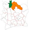
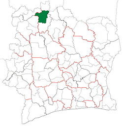 Location in Ivory Coast. Kouto Department has retained the same boundaries since its creation in 2008. |
| Country |  Ivory Coast Ivory Coast |
|---|
| District | Savanes |
|---|
| Region | Bagoué |
|---|
| 2008 | Established as a second-level subdivision via a division of Boundiali Dept |
|---|
| 2011 | Converted to a third-level subdivision |
|---|
| Departmental seat | Kouto |
|---|
| Government |
|---|
| • Prefect | Clément Koumé Bi Kalou |
|---|
| Area |
|---|
| • Total | 3,560 km2 (1,370 sq mi) |
|---|
| Population |
|---|
| • Total | 175,587 |
|---|
| • Density | 49/km2 (130/sq mi) |
|---|
| Time zone | UTC+0 (GMT) |
|---|
Kouto Department is a department of Bagoué Region in Savanes District, Ivory Coast. In 2021, its population was 175,587 and its seat is the settlement of Kouto. The sub-prefectures of the department are Blességué, Gbon, Kolia, Kouto, and Sianhala.
History
Kouto Department was created in 2008 as a second-level subdivision via a split-off from Boundiali Department.[4] At its creation, it was part of Savanes Region.
In 2011, districts were introduced as new first-level subdivisions of Ivory Coast. At the same time, regions were reorganised and became second-level subdivisions and all departments were converted into third-level subdivisions. At this time, Kouto Department became part of Bagoué Region in Savanes District.
Notes
- ^ "Préfets de Région et de Préfets de Département (Conseil des ministres du mercredi 26 septembre 2012)", abidjan.net, 2 October 2012.
- ^ "Le département de Kouto", rezoivoire.net, accessed 26 February 2016.
- ^ Citypopulation.de Population of the regions and departments of Ivory Coast
- ^ Décret n° 2008-96 du 5 mars 2008 portant création des départements de Bettié, Botro, Guéyo, Koro, Kouto, Ouangolodougou, Sinématiali, Tiapoum, Yakassé-Attobrou et Zoukougbeu.
9°54′N 6°25′W / 9.900°N 6.417°W / 9.900; -6.417
 | This Savanes District location article is a stub. You can help Wikipedia by expanding it. |

 Ivory Coast