Tanda Department
Department in Zanzan, Ivory Coast
Tanda Department Département de Tanda | |
|---|---|
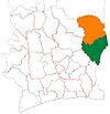
 Location in Ivory Coast. Tanda Department has had these boundaries since 2009. | |
| Country |  Ivory Coast Ivory Coast |
| District | Zanzan |
| Region | Gontougo |
| 1988 | Established as a first-level subdivision via a division of Bondoukou Dept |
| 1997 | Converted to a second-level subdivision |
| 2005 | Divided to create Koun-Fao Dept |
| 2009 | Divided to create Transua Dept |
| 2011 | Converted to a third-level subdivision |
| Departmental seat | Tanda |
| Government | |
| • Prefect | Andjou Koua |
| Area | |
| • Total | 1,670 km2 (640 sq mi) |
| Population (2021 census)[2] | |
| • Total | 113,523 |
| • Density | 68/km2 (180/sq mi) |
| Time zone | UTC+0 (GMT) |
Tanda Department is a department of Gontougo Region in Zanzan District, Ivory Coast. In 2021, its population was 113,523 and its seat is the settlement of Tanda. The sub-prefectures of the department are Amanvi, Diamba, Tanda, and Tchèdio.
History


Tanda Department was created in 1988 as a first-level subdivision via a split-off from Bondoukou Department.[3]
In 1997, regions were introduced as new first-level subdivisions of Ivory Coast; as a result, all departments were converted into second-level subdivisions. Tanda Department was included in Zanzan Region.
In 2005, Tanda Department was divided with the split-off creation of Koun-Fao Department.[3] Tanda Department was divided again in 2009 with the creation of Transua Department.[3]
In 2011, districts were introduced as new first-level subdivisions of Ivory Coast. At the same time, regions were reorganised and became second-level subdivisions and all departments were converted into third-level subdivisions. At this time, Tanda Department became part of Gontougo Region in Zanzan District.
Notes
- v
- t
- e
Regional seat: Bondoukou
* also a commune

7°48′N 3°10′W / 7.800°N 3.167°W / 7.800; -3.167
 | This Zanzan District location article is a stub. You can help Wikipedia by expanding it. |
- v
- t
- e


