Tengréla Department
Department in Savanes, Ivory Coast
Tengréla Department Département de Tengréla Tingréla Department | |
|---|---|
 Location in Ivory Coast. Tengréla Department has retained the same boundaries since its creation in 1980. | |
| Country |  Ivory Coast Ivory Coast |
| District | Savanes |
| Region | Bagoué |
| 1980 | Established as a first-level subdivision via a division of Boundiali Dept |
| 1997 | Converted to a second-level subdivision |
| 2011 | Converted to a third-level subdivision |
| Departmental seat | Tengréla |
| Government | |
| • Prefect | Konin Dindé |
| Area | |
| • Total | 2,300 km2 (900 sq mi) |
| Population (2021 census)[2] | |
| • Total | 141,761 |
| • Density | 62/km2 (160/sq mi) |
| Time zone | UTC+0 (GMT) |
Tengréla Department (also spelled Tingréla) is a department of Bagoué Region in Savanes District, Ivory Coast. In 2021, its population was 141,761 and its seat is the settlement of Tengréla. The sub-prefectures of the department are Débété, Kanakono, Papara, and Tengréla. It is the northernmost department of Ivory Coast.
History
Tengréla Department was created in 1980 as a first-level subdivision via a split-off from Boundiali Department.[3]
In 1997, regions were introduced as new first-level subdivisions of Ivory Coast; as a result, all departments were converted into second-level subdivisions. Tengréla Department was included in Savanes Region.
In 2011, districts were introduced as new first-level subdivisions of Ivory Coast. At the same time, regions were reorganised and became second-level subdivisions and all departments were converted into third-level subdivisions. At this time, Tengréla Department became part of Bagoué Region in Savanes District.
Notes
- v
- t
- e
|

| Gbôklé Region | |
|---|---|
| Nawa Region | |
| San-Pédro Region |
| Indénié-Djuablin Region |
|
|---|---|
| Sud-Comoé Region |
|
| Folon Region | |
|---|---|
| Kabadougou Region |
|
| Gôh Region | |
|---|---|
| Lôh-Djiboua Region |
| Bélier Region | |
|---|---|
| Iffou Region |
|
| Moronou Region |
|
| N'Zi Region |
|
| Agnéby-Tiassa Region | |
|---|---|
| Grands-Ponts Region |
|
| La Mé Region |
|
| Cavally Region | |
|---|---|
| Guémon Region | |
| Tonkpi Region |
|
| Haut-Sassandra Region |
|
|---|---|
| Marahoué Region |
| Bagoué Region | |
|---|---|
| Poro Region |
|
| Tchologo Region |
|
| Gbêkê Region | |
|---|---|
| Hambol Region |
|
| Bafing Region | |
|---|---|
| Béré Region | |
| Worodougou Region |
|
| Bounkani Region | |
|---|---|
| Gontougo Region |
|
| ||
|---|---|---|
Regional seat: Boundiali | ||
| Boundiali Department | 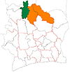 | |
| Kouto Department | ||
| Tengréla Department | ||
* also a commune | ||
Authority control databases | |
|---|---|
| International |
|
| National |
|
10°29′N 6°23′W / 10.483°N 6.383°W / 10.483; -6.383
 | This Savanes District location article is a stub. You can help Wikipedia by expanding it. |
- v
- t
- e


