Tiassalé Department
Department in Lagunes, Ivory Coast
Tiassalé Department Département de Tiassalé | |
|---|---|
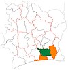
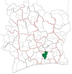 Location in Ivory Coast. Tiassalé Department has had these boundaries since 2012. | |
| Country |  Ivory Coast Ivory Coast |
| District | Lagunes |
| Region | Agnéby-Tiassa |
| 1988 | Established as a first-level subdivision via a division of Abidjan Dept |
| 1997 | Converted to a second-level subdivision |
| 2011 | Converted to a third-level subdivision |
| 2012 | Divided to create Taabo Dept |
| Departmental seat | Tiassalé |
| Government | |
| • Prefect | Jules Gouesse |
| Area | |
| • Total | 2,360 km2 (910 sq mi) |
| Population (2021 census)[2] | |
| • Total | 278,954 |
| • Density | 120/km2 (310/sq mi) |
| Time zone | UTC+0 (GMT) |
Tiassalé Department is a department of Agnéby-Tiassa Region in Lagunes District, Ivory Coast. In 2021, its population was 278,954 and its seat is the settlement of Tiassalé. The sub-prefectures of the department are Gbolouville, Morokro, N'Douci, and Tiassalé.
History

Tiassalé Department was created in 1988 as a first-level subdivision via a split-off from Abidjan Department.[3]
In 1997, regions were introduced as new first-level subdivisions of Ivory Coast; as a result, all departments were converted into second-level subdivisions. Tiassalé Department was included in Lagunes Region.
In 2011, districts were introduced as new first-level subdivisions of Ivory Coast. At the same time, regions were reorganised and became second-level subdivisions and all departments were converted into third-level subdivisions. At this time, Tiassalé Department became part of Agnéby-Tiassa Region in Lagunes District.
In 2012, two sub-prefectures were split from Tiassalé Department to create Taabo Department.[4]
Notes
- ^ "Préfets de Région et de Préfets de Département (Conseil des ministres du mercredi 26 septembre 2012)", abidjan.net, 2 October 2012.
- ^ Citypopulation.de Population of the regions and departments of Ivory Coast
- ^ "Regions of Côte d'Ivoire (Ivory Coast)", statoids.com, accessed 16 February 2016.
- ^ "Le décret n° 2012-611 du 04 juillet 2012 portant création des Départements de Djékanou, Sipilou, Kong, Gbéléban, Taabo, Kouassi-Kouassikro, Méagui, Séguélon, Buyo, M'Bengué, Facobly et Dianra".
- v
- t
- e
Regional seat: Agboville
* also a commune

| Authority control databases |
|
|---|
5°54′N 4°50′W / 5.900°N 4.833°W / 5.900; -4.833
 | This Lagunes District location article is a stub. You can help Wikipedia by expanding it. |
- v
- t
- e


